The eruption of the world’s largest volcano, Mauna Loa, appears to have come to an end; the same is true for nearby Kilauea, which stopped erupting fresh lava on the surface of the Big Island of Hawaii in recent days. While the Hawaiian Volcano Observatory unit of USGS continues to monitor both volcanoes for any signs of unrest, they have dropped the alert and advisory level of both down to advisory / yellow level down from the watch / orange level they were most recently at.
Dr. Ken Hon, Scientist-in-Charge of HVO, told reporters in a morning press conference today that Mauna Loa is no longer erupting. Lava supply to an active fissure on the Northeast Rift Zone, which was fountaining lava up to 500′ high last Wednesday night, ceased on December 10 while sulfur dioxide emissions have decreased to near pre-eruption background levels.
Spots of incandescence may remain near the vent, along channels, and at the flow front for days or weeks as the lava flows cool. However, eruptive activity is not expected to return based on past eruptive behavior.
While the lava that spread in this most recent eruption is cooling and no longer glows red at night, it is still very hot. Dr. Hon tells us the flows’ surface or just inches below the surface remain extremely hot, with temperatures that could quickly boil water. A person could encounter serious burns by walking near this recent flow and could be seriously burned or killed if they fell through loose rocky material into the very hot rock that remains below the surface.
While Mauna Loa goes quiet, so does Kilauea. Lava supply to the Halema’uma’u lave lake ceased on December 9 based on lava lake levels and behavior of the crater floor. HVO says sulfur dioxide emissions have decreased to near pre-eruption background levels.
While the two active volcanoes on the Big Island of Hawaii have gone quiet, HVO says they remain on the job. “HVO continues to closely monitor Kīlauea for signs of renewed activity. Should volcanic activity change significantly a new Volcanic Activity Notice will be issued,” HVO said in a statement released today.
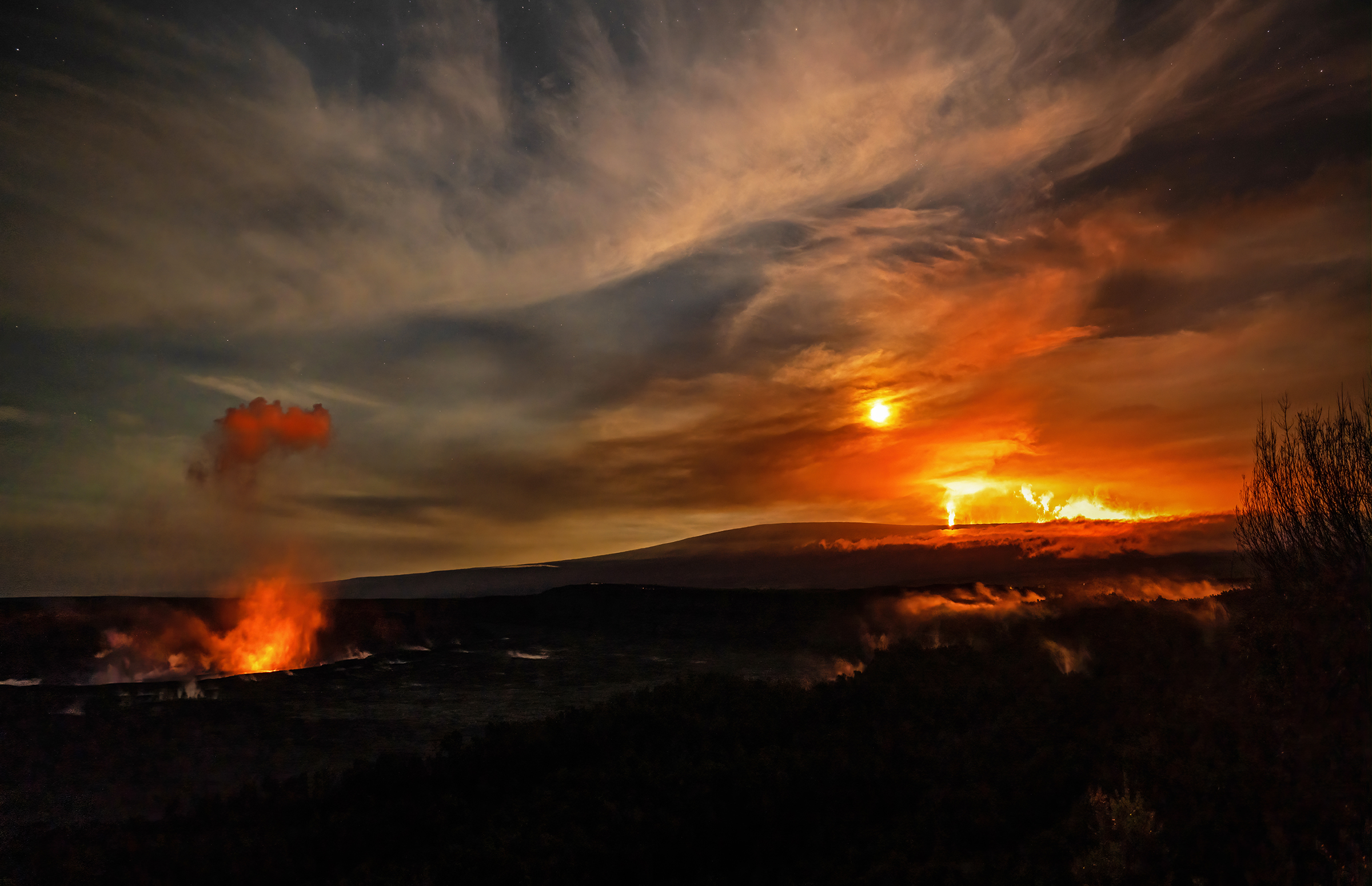
During the Mauna Loa eruption, glow from lava erupting from it and Kilauea could be seen from inside Hawaii Volcanoes National Park –a scene not seen since 1984, Mauna Loa’s last eruption which also impacted the volcano’s northeast rift zone. 200-250 million cubic meters of lava were added to the Big Island during the 12 day eruption.
While the eruption is over, large parts of the Mauna Loa volcano remain closed to the public –and will likely remain so for a long time. Much of the lava from this November/December 2022 eruption covered land within Hawaii Volcanoes National Park.
We asked Jessica Ferracane, Public Affairs Specialist, for Hawaii Volcanoes National Park when some of the roads and trails closed by the eruption may re-open.
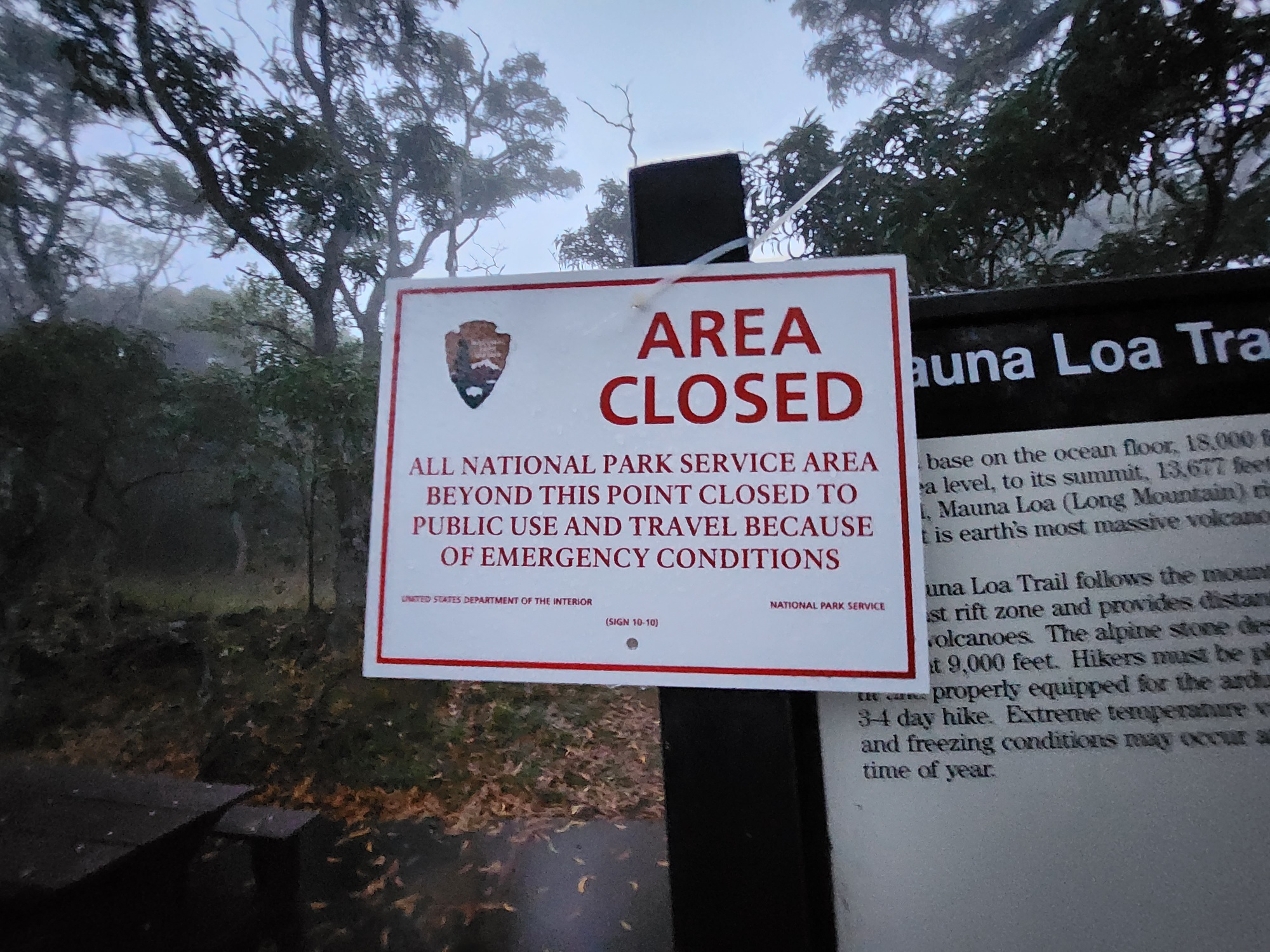
“We don’t know how long it will take to fix the sections of Mauna Loa Trail that were inundated with lava, but the trail and backcountry cabins will remain closed until after the eruption stops and until the park has a chance to do a thorough assessment and repair trail damage,” Ferracane said. “Based on overflight imagery, we know that 6.26 km (3.8 miles) of Mauna Loa Trail was inundated by lava, which impacts/disrupts about a 9.5 km (5.9 mile) section of the historic trail. ” She added, “For comparison, in 2018 it took over a year for the park to repair and reopen the most popular trail, Kīlauea Iki Trail, following the massive summit collapse.”
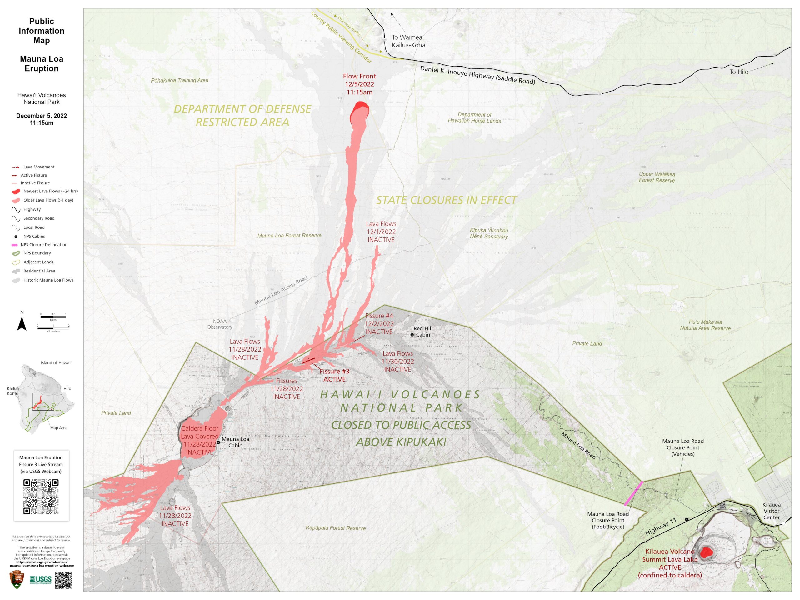
Mauna Loa Road is open to pedestrians and bicyclists from the gate past Kīpukapuaulu to the second cattle guard – about 4 ¼ miles, which opens up more recreational opportunities. The road from the gate to where it ends at the Mauna Loa Lookout (6,667 ft. elevation) remains closed to vehicles.
In October, when Maua Loa was showing signs of a possible eruption, the National Park Service closed the trails leading off of Mauna Loa Road. Once the eruption began, the road was closed and has remained closed since.
Ferracane says, ” Mauna Loa Road is open to pedestrians and bicyclists from the gate past Kīpukapuaulu to the second cattle guard – about 4 ¼ miles, which opens up more recreational opportunities. The road from the gate to where it ends at the Mauna Loa Lookout (6,667 ft. elevation) remains closed to vehicles.”
“While the volcanic hazard may not be present for most drivers, closing the road reduces access to the summit and flow fields where the hazards (lava, unstable ground, deadly gases, spatter and other ejecta like Pele’s Hair) are occurring. Visitors don’t always obey closure signs, and will sometimes go into closed areas to view lava. This illegal action puts them and first responders at great risk –it is a remote, high-elevation area that takes hours to reach on foot, ” Ferracane warned.
Beyond the National Park territory, other land is opening while other remains closed. The Hawaii Department of Land and Natural Resources announced today the re-opening of three key areas closed during the eruption over the last 2 weeks: Kapāpala Forest Reserve, ʻĀinapō Trail, road, and cabin , and the Kīpuka ʻĀinahou Nēnē Sanctuary.
However, the Mauna Loa Forest Reserve and the Mauna Loa Observatory Road remain closed. DNLR says that a gate is being constructed at the Mauna Loa Forest Reserve boundary on the Mauna Loa Access road and will be locked until further notice. This is the road that travels up to the HI-SEAS research facility and a NOAA weather and climate observatory from the Daniel K. Inouye Highway, also known as Saddle Road by locals on the Big Island.
DLNR also says that a portion of Unit A South of Daniel K. Inouye Highway within the Mauna Kea Forest Reserve and Game Management Area will remain closed for hunting until further notice.
Dan Dennison, Senior Communications Manager for DLNR warns, “People are reminded that it is illegal to cross into any closed area and violators can be cited or arrested. ”
The Volcano Hazards Program Office, through regional groups responsible for volcanoes of concern within their geographic area of concern, is responsible for issuing Aviation Codes and Volcanic Activity Alert Levels. Aviation Codes are green, yellow, orange, or red. When ground-based instrumentation is insufficient to establish that a volcano is at a typical background level of activity, it is simply “unassigned.” While green means typical activity associated with a non-eruptive state, yellow means a volcano is exhibiting signs of elevated unrest above known background levels. When a volcano exhibits heightened or escalating unrest with the increased potential of eruption, it jumps to orange. Finally, when an eruption is imminent with significant emission of volcanic ash expected in the atmosphere or an eruption is underway with significant emission of volcanic ash into the atmosphere, the code becomes red. Volcanic Activity Alert levels are normal, advisory, watch, or warning. As with aviation codes, if data is insufficient, it is simply labeled as “unassigned.” When the volcano is at typical background activity in a non-eruptive state, it is considered normal. If the volcano exhibits signs of elevated unrest above background level, an advisory is issued. If a volcano exhibits heightened or escalating unrest, a watch is issued while a warning is issued when a hazardous eruption is imminent.
The Hawaii Volcano Observatory (HVO) monitors the Kilauea, Mauna Loa, and Hualalai volcanoes on the Big Island of Hawaii. While they have dropped Kilauea and Mauna Loa down to Advisory / Yellow status, Hualalai remains Normal / Green.
Civil Defense for Hawaii County is also partnering with HVO to provide guidance to residents on this eruption threat and future eruption threats. In today’s press conference, Civil Defense Administrator Talmadge Magno said January is Volcano Awareness Month and that they plan to work closely with HVO to keep the community informed about preparing for and being aware of volcanic dangers that continue to exist on the volcanic island.
