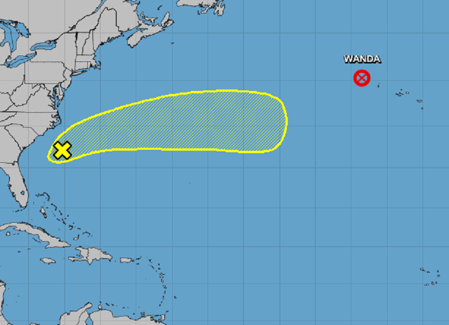
In the Atlantic Hurricane Basin, meteorologists at the National Hurricane Center in Miami, Florida are tracking two systems: Wanda and the Nor’Easter that’s battered the southeast coast this weekend. Tropical Storm Wanda meanwhile has transitioned into a post-tropical cyclone; due to the transition, the National Hurricane Center has issued its last advisory on it.
As of the last update on Wanda today by the National Hurricane Center (NHC), Wanda was located about 380 miles west-northwest of the Azores and was racing to the northeast at 25 mph with 40 mph maximum sustained winds. The post-tropical cyclone is expected to continue its northeast march with further acceleration through Monday. While Wanda as a post-tropical cyclone is forecast to merge with a frontal system tonight and dissipate as its own entity by tomorrow, the remnants of former Tropical Storm will bring wind-whipped rains to portions of Ireland and the United Kingdom Tuesday into Wednesday.
While the NHC has ended advisories for Wanda, three European weather agencies are tracking the system. Meteo France, the meteorological agency from France, is issuing High Seas Forecasts for the northeastern Atlantic Ocean in and around this storm system. Met Éireann, the meteorological agency for Ireland, is calling for impacts late Tuesday into early Wednesday there. “Spells of rain” are forecast to be followed by “hazy sunny spells” by the Irish weather service, suggesting that the heaviest rain will be across the southern half of the country Tuesday night. The third European agency tracking the storm is the UK Met Office in the United Kingdom; they’re forecast rain and wind for when this system moves through on Wednesday. Conditions will remain unsettled for most of the UK during much of the upcoming week.
While Wanda evolves, eyes are also on the potent area of low pressure responsible for wind-whipped heavy rains and coastal flooding around the southeastern United States this weekend. A non-tropical low pressure system with storm-force winds is located about 200 miles south of Cape Hatteras, North Carolina. According to the NHC, this system is forecast to move east-northeastward over the next few days and could gradually acquire some subtropical characteristics as it moves across the subtropical Atlantic ocean along the warm Gulf Stream current. However, odds of tropical or subtropical cyclone generation are low for now; the NHC says there’s only a 10% chance of formation over the next 48 hours and a 20% chance over the next five days. Nevertheless, the NHC will continue to monitor this area for any signs of development in the coming days.
Elsewhere, the Atlantic Hurricane Basin is quiet. The NHC expects no other areas of tropical cyclone development anywhere in the basin for at least the next five days. The Atlantic Hurricane Season has just 3 weeks left, ending on the last day of the month.