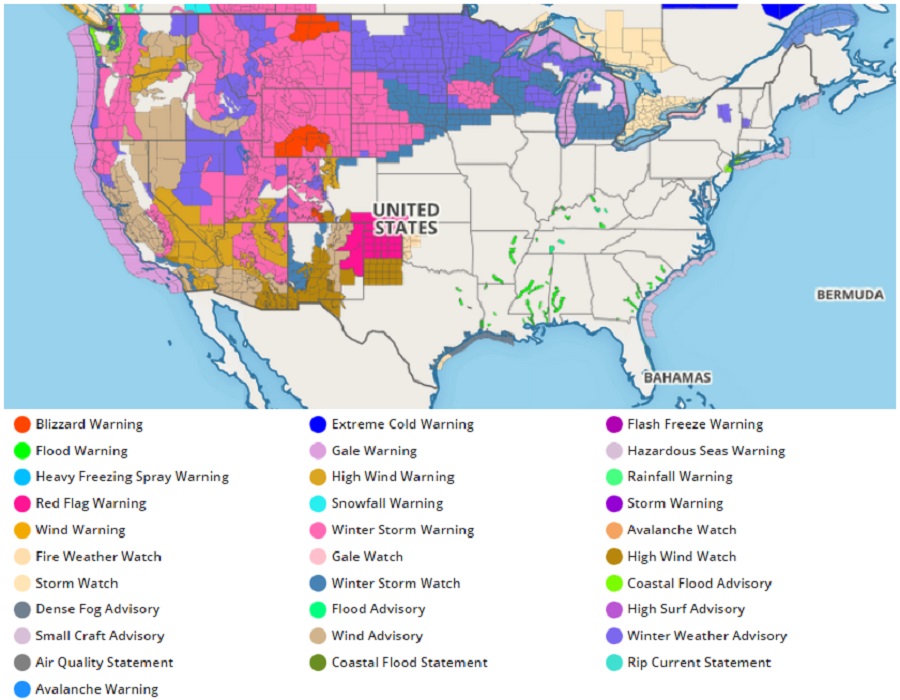
The National Weather Service has been busy issuing hundreds of watches and warnings ahead of a major storm that is heading East; as a result, the advisory map on Weatherboy.com is lit-up with numerous alerts. Winter Storm Warnings are the most common issued right now, with a large area of hazardous, wintry weather expected. The storm will produce a large swath of heavy snow from the West Coast to the Northeast through Thursday. However, the I-95 corridor that has been missing snow much of this winter will miss it again, with most snow staying over interior New England away from the big Mid Atlantic and Northeast cities. In addition to rough weather, widespread record breaking cold in the West and record breaking warmth in the East are possible on Wednesday and Thursday as this storm system moves through.
According to the National Weather Service’s Weather Prediction Center, a shortwave trough will rapidly amplify while it digs into the West over the next couple of days. This strong upper-level energy will bring with it a substantial supply of Pacific moisture. An Arctic front will develop over top of the surface wave and shift southward beneath the developing upper low, providing the anomalously cold air needed for a major winter storm to unfold over the northern tier of the country this week. A southern stream trough in the Southwest will enhance the pressure gradient over the West and Midwest leading to strong winds in those areas. While subtle shifts in the storm track remain possible, the National Weather Service says confidence is high that this winter storm will be extremely disruptive to travel, livestock, and recreation in affected areas.
Heavy snow and strong winds will develop over the Northern Rockies tonight and spread southward across the Central/Southern Rockies on Tuesday and Wednesday while the upper trough digs into the West. The surface low pressure system will move into the Plains on Tuesday night and will spread heavy snow, strong winds freezing rain across the Northern Rockies, Upper Midwest, Great Lakes and interior Northeast on Wednesday. Winds gusting in excess of 30 mph may cause blizzard conditions over portions of the West and Midwest on Wednesday with power outages and tree damage possible. Snow totals between 2-4 feet with locally higher amounts are possible in the Western mountains, while 4-8 inches of snow is possible from the Northern/Central Plains to the interior Northeast by Wednesday evening. Snow and ice are expected to ramp up over the Upper Midwest, Great Lakes and Northeast Wednesday night into Thursday when the bulk of the snow ice are expected to accumulate leading to treacherous travel conditions.
Very cold temperatures are likely from the West Coast into the Northern Plains behind this system with record lows and dangerous wind chills possible. The potential also exists for flash freeze in portions of the Northern Rockies.
While cold air plunges behind the system, very warm temperatures will surge ahead of it. This milder air will be especially felt across the Southeast and Mid-Atlantic on Wednesday and Thursday prior to the arrival of the southern stream energy. Temperature records are expected to be tied or broken in the East and West as a result of this highly amplified pattern.
