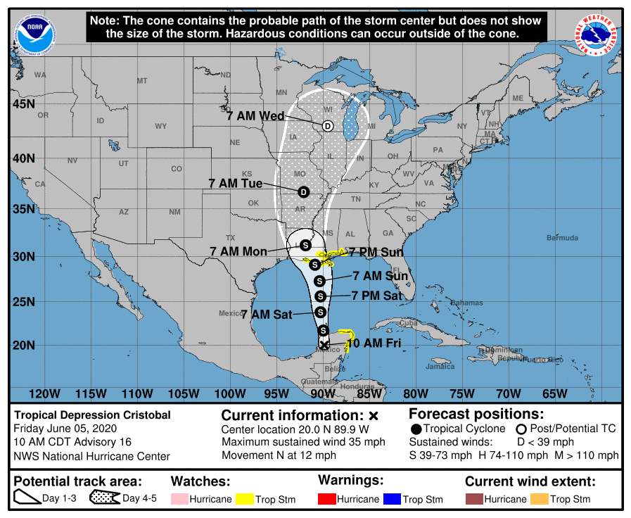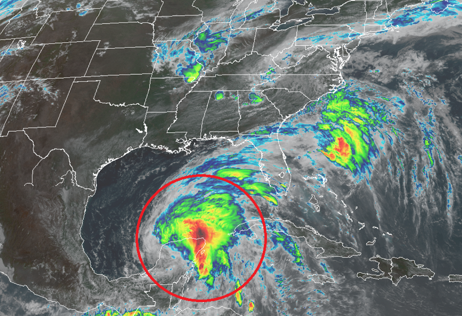
The National Hurricane Center (NHC) in Miami, Florida has issued Storm Surge and Tropical Storm Watches for portions of the United States Gulf of Mexico Coast ahead of Cristobal’s expected arrival late this weekend. While people across the entire Gulf Coast are urged to watch the evolving forecasts with this weekend for any changes in storm path or intensity, those under a watch now should act on their Hurricane Action Plan to make sure their property and people they know are properly prepared and ready for the storm’s arrival.
As of the latest advisory from the NHC, Cristobal was located near latitude 20.0 North and longitude 89.9 West. Moving toward the north near 12 mph, the system, now as a Tropical Depression, has maximum sustained winds of 35 mph with higher gusts. The estimated central minimum pressure is 1000 mb or 29.53 inches.
On the latest forecast track released by the NHC, the center will move back over the southern Gulf of Mexico this evening, over the central Gulf of Mexico on Saturday, and be near the northern Gulf of Mexico coast Sunday evening. As it begins to moves away from Mexico, Cristobal is expected to regain tropical storm strength later today with some additional strengthening forecast to happen soon after. The center of the intensifying storm is projected to move into the central Gulf of Mexico and move in the general direction of the central Gulf coast, prompting advisories to be issued.
A Storm Surge Watch has been issued for the northern Gulf of Mexico coast from Indian Pass to Arepika, Florida, and from Grand Isle, Louisiana, to Ocean Springs, Mississippi, including Lake Borgne; a Tropical Storm Watch has been issued for the northern Gulf of Mexico coast from Intracoastal City Louisiana to the Alabama/Florida border, including Lake Pontchartrain and Lake Maurepas. A Storm Surge Watch means there is a possibility of life-threatening inundation, from rising water moving inland from the coastline, in the indicated locations during the next 48 hours. A Tropical Storm Watch means that tropical storm conditions are possible within the watch area, generally within 48 hours. Tropical storm conditions in the watch area in Mexico could occur through this afternoon.
As Cristobal heads north and gains strength, a very of hazards will present itself: storm surge, wind, heavy rain, and rough surf.
The combination of a dangerous storm surge and the tide will cause normally dry areas near the coast to be flooded by rising waters moving inland from the shoreline. The water could reach the following heights above ground somewhere in the indicated areas if the peak surge occurs at the time of high tide:
- Aripeka to Marco Island including Tampa Bay: 1-3′
- Grand Isle to Ocean Springs including Lake Borgne: 2-4′
- Indian Pass to Aripeka: 2-4′
- Ocean Springs to Indian Pass including Mobile Bay and Pensacola Bay: 1-3′
The deepest water will occur along the immediate coast in areas of onshore winds and will likely extend along the coast well to the east of the center. Surge-related flooding depends on the relative timing of the surge and the tidal cycle, and can vary greatly over short distances.

Tropical storm conditions are possible today within the Tropical Storm Watch area of the Yucatan Peninsula. Tropical storm conditions are possible within the Tropical Storm Watch area of the northern Gulf coast beginning early Sunday. It becomes difficult if not possible to work outside and prepare for an arriving tropical cyclone once tropical storm force winds arrive.
Very heavy rain is expected to fall from Cristobal in the coming days. Through Wednesday morning, for portions of the eastern and central Gulf Coast and the lower Mississippi Valley, rainfall accumulations of 4 to 8 inches, with local amounts to 12 inches, are forecast. Isolated significant river flooding is possible along the central Gulf Coast. Farther north across the Mid-Mississippi Valley, rainfall totals of 2 to 4 inches, with local amounts to 6 inches, are expected. Rises along smaller-order streams are possible across the Mid-Mississippi Valley. This degree of rainfall is expected to lead to flash flooding. The Mexican states of Campeche, Quintana Roo, and Yucatan will see an additional 4-6″ of rain, with isolated storm totals of around 25″. Belize and the Mexican states of Tabasco and Oaxaca will see an additional 4-6″ of rain, with isolated storm totals of around a foot. Southern Guatemala, coastal portions of Chiapas, and El Salvador will see an additional 4-6″ of rain, with isolated storm total amounts of up to 35″. In some of those areas, rain has been falling from Cristobal since May 30. In southern parts of Honduras, an additional 3-4″ are likely, with isolated 8″ amounts possible.
Swells generated by Cristobal will affect portions of the northern and eastern Gulf coast during the next few days. These swells are likely to cause life-threatening surf and rip current
conditions. Even expert swimmers should avoid the hazardous gulf waters until the storm has passed.
Cristobal is the third named storm of the 2020 Atlantic Hurricane Season, which just started on Monday. It is expected to be a very busy season, with experts yesterday unveiling a new outlook suggesting even more storms will form than initially thought. The hurricane season runs through November 30, 2020 in the Atlantic basin.
With impacts to the United States expected in the coming days, the National Hurricane Center recommends that people develop a written action plan, consider helping neighbors in their planning process, make sure their homes are strengthened prior to being threatened by a tropical system, make sure insurance is in-order, stock up on essential supplies, develop an evacuation plan, and ultimately identify and determine any risks you may face from a storm.