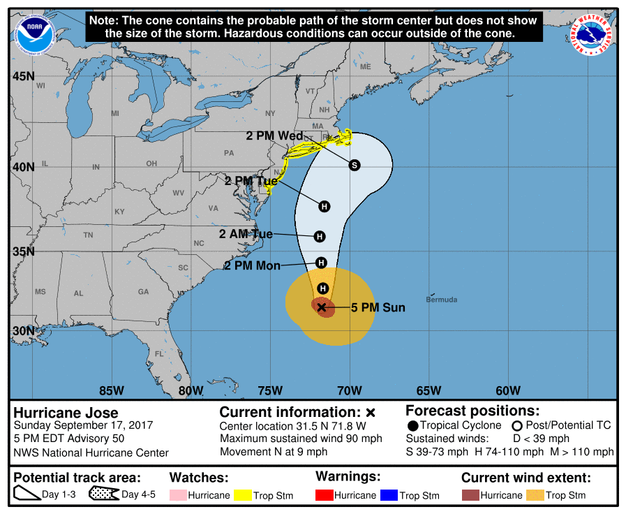
The National Hurricane Center has issued Tropical Storm Watches for portions of the Mid Atlantic coast from Delaware to Massachusetts. While Hurricane Jose’s forecast cone from the National Hurricane Center (NHC) shows the center of the storm well off-shore, the storm will grow in size as it moves north, with an expansive wind field that extends well outside of the forecast cone. Because tropical storm force winds could reach well west of the center of the storm, the National Hurricane Center has issued Tropical Storm Watches.
A Tropical Storm Watch is in effect from Fenwick Island, Delaware, to Sandy Hook, New Jersey, including Delaware Bay South, and from East Rockaway Inlet, New York, to Plymouth, Massachusetts, including Long Island Sound, Block Island, Martha’s Vineyard, and Nantucket.
The National Hurricane Center wants to make these four points known:
- While the center of Jose is currently forecast to remain offshore of the U.S. coast, the large cyclone could cause some direct impacts from Delaware northward to New England, and any deviation to the left of the NHC forecast track would increase the likelihood and
magnitude of those impacts. A tropical storm watch is now in effect from the Delaware coast to southeastern Massachusetts. Interests elsewhere along the U.S. east coast from North Carolina to New England should monitor the progress of Jose through the next several days. - Minor to moderate coastal flooding is possible from Delaware to southern New England during the next several days.
- Swells generated by Jose are affecting Bermuda, the Bahamas, and much of the U.S. east coast. These swells are likely to cause dangerous surf and rip current conditions for the next several days in these areas.
- Jose will produce heavy rain as it passes near southern New England and the mid-Atlantic on Tuesday and Wednesday. Total accumulations of three to five inches are expected over eastern Long Island, southern Rhode Island, and southeast Massachusetts, including Martha’s Vineyard and Nantucket. Based on the current forecast, the risk of flooding will be limited in scope. Any deviation to the left of the forecast track, however, could bring heavier and more widespread rainfall to southern New England, Long Island, New York City, and New Jersey. If this deviation were to occur, the risk of urban flash flooding and some river flooding would increase.
Hurricane Jose is joined by Hurricane Maria and Tropical Storm Lee in the Atlantic; this trio of storms is being monitored by the NHC. Those under Tropical Storm or Hurricane Watches from either Hurricane Jose or Hurricane Maria should act on their Hurricane Action Plan now. Others along the coastal regions should simply make sure they have a Hurricane Action Plan; it may become necessary to act on it soon.
Experts believe this Atlantic Hurricane Season, which runs through to the end of November, will be a busy one. Dr. Phil Klotzbach and the experts at Colorado State University updated their seasonal outlook again on July 5, showing a much more active than normal season expected. The National Oceanic and Atmospheric Administration (NOAA) also released their own forecast which shows this hurricane season to be likely more active than others.