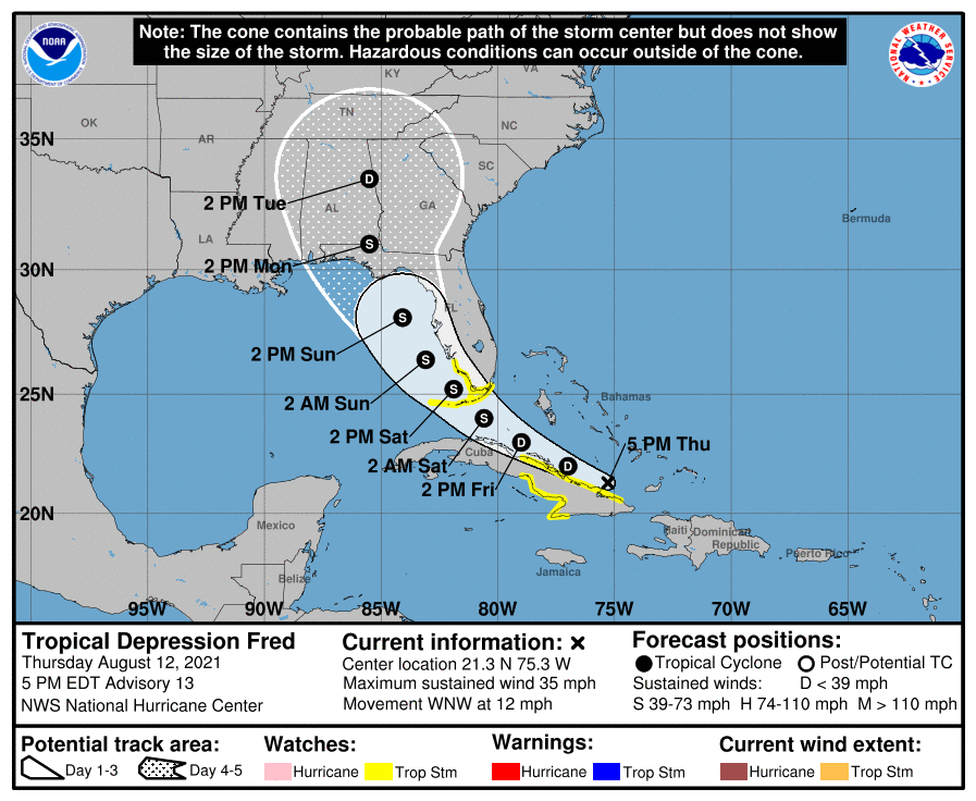
The National Hurricane Center (NHC) in Miami, Florida has issued Tropical Storm Watches for the Florida Keys and portions of south Florida as Fred, now a tropical depression, approaches the U.S. Right now, Fred is continuing just above the north coast of Cuba, inching its way closer to what is likely an inevitable rendezvous with the Sunshine State.
As of the 5pm advisory from the NHC, Fred was located 470 miles east-southeast of Key West, Florida and about 165 miles east of Camaguey Key, Cuba. With maximum sustained winds of 35 mph, the system was moving to the west-northwest at 12 mph. Fred’s estimated minimum central pressure is 1012 mb or 29.89″.
The National Hurricane Center has issued a Tropical Storm Watch for the Florida Keys from Ocean Reef to the Dry Tortugas, and for the southwest coast of the Florida Peninsula from Bonita Beach south and east to Ocean Reef, including Florida Bay. A Tropical Storm Watch means that tropical storm conditions are possible within the watch area. The NHC says additional watches and warnings may be required for portions of these areas tonight and Friday.
The NHC expects Fred to continue to move west-northwest through tomorrow night or Saturday morning, and then move more north than west this weekend. On the forecast track, Fred is expected to move along or just north of eastern and central Cuba tonight and Friday, and be near the Florida Keys and southern Florida on Saturday.
The NHC says little change in strength is expected through tonight. Slow strengthening is expected Friday through Saturday, and Fred is forecast to regain tropical storm strength as it nears the Florida Keys and south Florida.
Heavy rain, strong winds, and rough surf will be whipping Florida in the coming days. From Friday into Monday, 3-6″ of rain is anticipated across the Florida Keys, the southern and central Florida Peninsula, and north towards the Big Bend of Florida, with isolated maximum totals of 8″. Heavy rainfall could lead to areal, urban, and small stream flooding, and potentially exacerbate ongoing minor to isolated moderate river flooding. Tropical storm wind conditions are possible in the watch area in Florida beginning Friday night. Wind gusts to tropical storm force may also occur over portions of the southeastern Bahamas tonight. Swells generated by Fred are expected to spread across portions of the Bahamas and northern coast of Cuba during the next couple of days. These swells could reach the Florida Keys and southern Florida by early Saturday.
