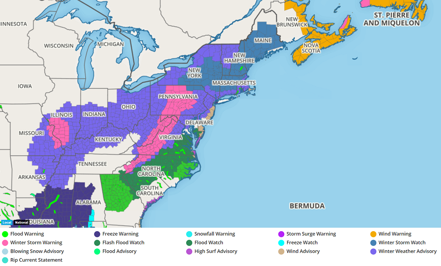
A significant winter storm will move through the northeast tomorrow, prompting the National Weather Service to issue Winter Storm Watches, Winter Storm Warnings, and Winter Weather Advisories for snow, sleet, and freezing rain.
Early in the day Thursday, low pressure will be centered near the Carolina coast with a cold high centered over New England. The low is forecast to take a track north along the coast through the day reaching a point over eastern Virginia or the Chesapeake Bay by Thursday evening. Due to the cold airmass in place at the onset, many areas in Maryland, interior Virginia, Pennsylvania, New Jersey, Delaware, and points north look to start as snow or snow mixed with sleet and freezing rain Thursday morning. The exception will be parts of the DelMarVa and the immediate south Jersey Shore where it may be pretty much all rain due to strengthening northeast winds bringing in milder marine air. Some of those on-shore winds are expected to pick up in intensity throughout the day, creating wind advisory level winds there. The strengthening easterly flow and warm advection pattern to the north of the low will result in the atmospheric profiles warming, especially well above the surface. This will result in snow and sleet generally transitioning to a wintry mix of snow, sleet, freezing rain and eventually rain from south to north. By late afternoon, most of the I-95 corridor at least from around Trenton, New Jersey and south should be mainly rain and this may fall moderate to heavy at times.
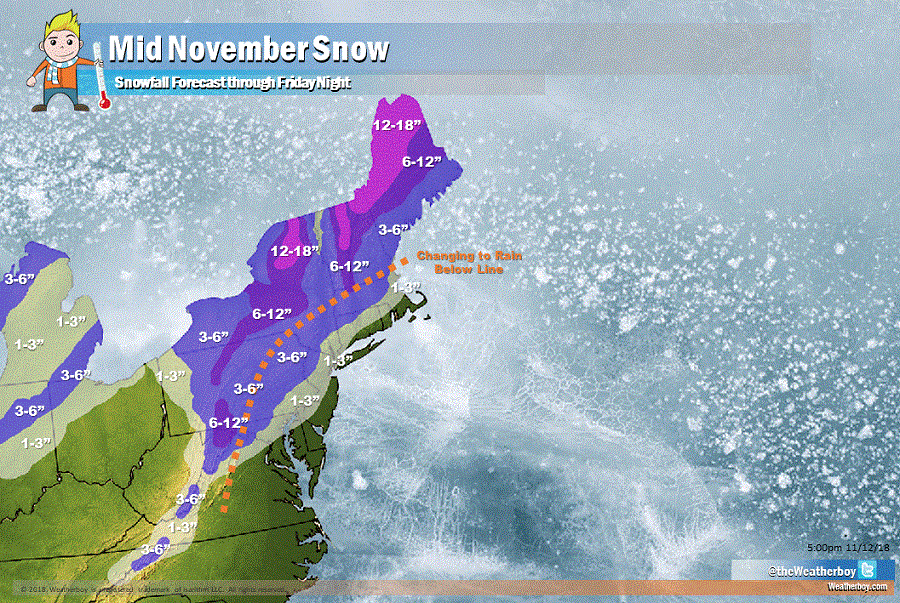
Tomorrow night, low pressure will continue advancing north while rapidly deepening, taking a track right along the coast or just
inland. The transition for snow/wintry mix to rain should continue south to north except that areas north of the I-78/I-80 corridor where conditions should remain below freezing throughout the storm. Farther south, with the low tracking near or right overhead this may result in a lull in the precipitation Thursday evening as a dry slot may try to work in from the south. Daytime highs over the I-95 corridor will only be in the 30s but as the low moves through this will draw up milder air so actually expect temps to rise into Thursday night. In fact parts of NJ and the Delmarva look to temporarily rise into the 40s to low 50s.
By early Friday, the low center will be near New York City, drawing in very strong northwest winds with falling temperatures in its wake. This could result in a changeover back to snow as far south as Philadelphia as temperatures fall back through the 30s with the cold advection in the low`s wake. In fact, this “backlash” snow could even be briefly heavy as the low continues to rapidly deepen as it pulls away. With the storm accelerating away, any lingering precipitation Friday morning should clear out relatively quickly, with dry conditions returning from southwest to northeast during the afternoon.
