A significant winter storm is developing and Texas will be among the first states to be impacted by it; as a result, state government is preparing for the imminent weather emergency as the National Weather Service issues Winter Storm Watches for most of the Lone Star State including the major metropolitan areas of Dallas, Houston, and Austin.
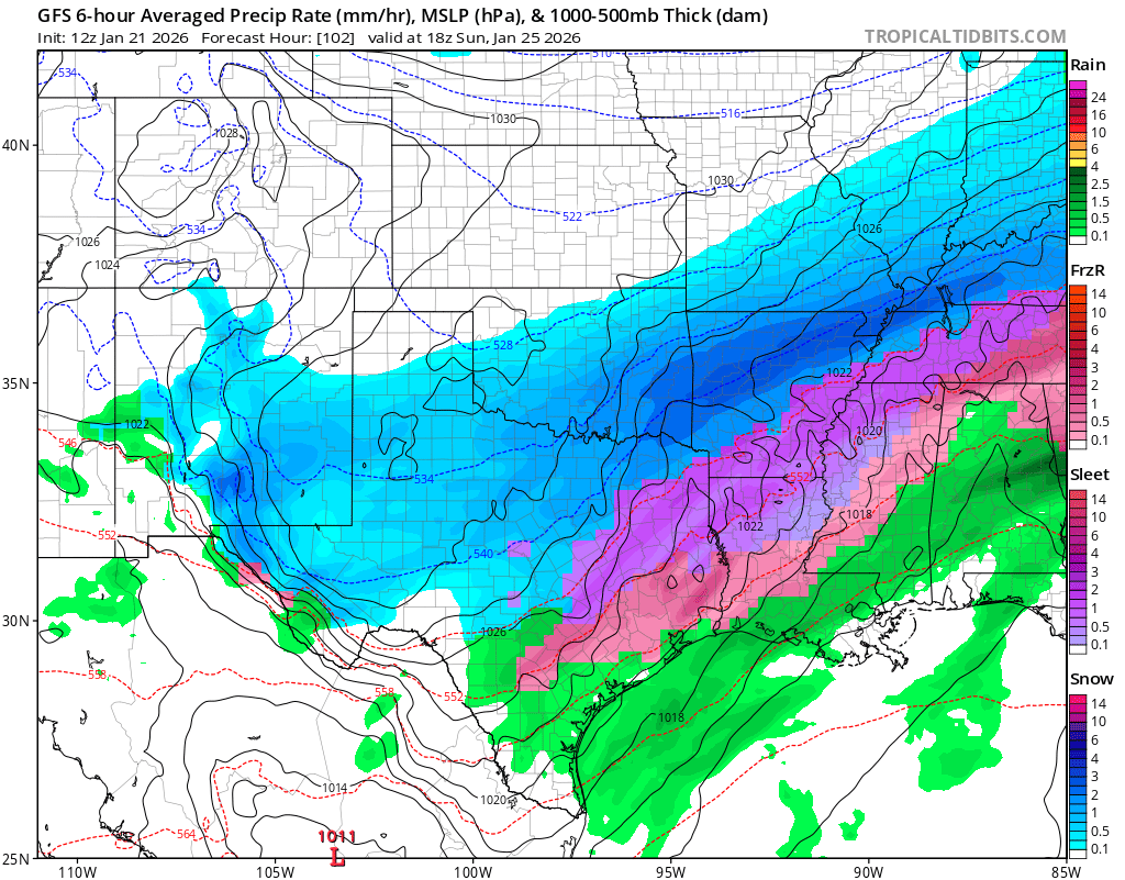
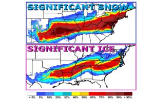
A significant intrusion of Arctic air and impactful wintry precipitation will affect all of North and Central Texas from Friday afternoon/evening through the upcoming weekend. Impacts to travel and infrastructure are expected across all of North and Central Texas due to a combination of freezing rain/ice as well as sleet and snow, while temperatures stay below freezing for an extended period. A Winter Storm Watch is now in effect for the entirety of North and Central Texas starting Friday afternoon and continuing through Sunday morning.
“Plan ahead for travel impacts and power outages, and monitor forecasts in the coming days for up-to-date information,” the National Weather Service warns.
Texas Governor Greg Abbott announced that he directed the Texas Division of Emergency Management (TDEM) to activate state emergency response resources ahead of potential winter weather impacts expected across the state beginning Thursday.
“Based on current forecasts, the State of Texas is acting to ensure Texans have the resources they need before severe winter weather impacts communities across Texas,” said Governor Abbott. “As temperatures could drop below freezing and regions of Texas face snow, ice, and freezing rain, it is crucial that Texans remain weather-aware, check DriveTexas.org before traveling, and heed the guidance of state and local officials. I thank emergency management personnel and first responders for working tirelessly to keep Texans safe.”
At the direction of the Governor, TDEM has activated the following state emergency response resources to support weather response operations:
- – Texas Department of Transportation: Winter weather roadway equipment and crews pre-treating and treating roadways; personnel and equipment to assist with traffic control and road closures
- – Texas Division of Emergency Management: The State of Texas Incident Management Team; personnel working with local partners to update warming center maps
- – Texas National Guard: High-profile vehicles and personnel to support stranded motorists
- – Texas A&M Forest Service (Texas Intrastate Fire Mutual Aid System): All-Hazard Strike Teams consisting of firefighters, engines, and equipment such as motor graders to assist with snow/ice clearance; saw crews
- – Texas Parks and Wildlife Department: Game Wardens to support local law enforcement; high-profile vehicles to assist stranded motorists
- – Public Utility Commission of Texas: Power outage monitoring and coordinating with utility providers across the threat area
- – Railroad Commission of Texas: Monitoring of the state’s natural gas supply and communication with the oil and gas industry
- – Texas Commission on Environmental Quality: Air/water/wastewater monitoring
- – Texas Department of Public Safety: Texas Highway Patrol Troopers to patrol Texas roadways
- – Texas A&M Engineering Extension Service (Public Works Response Team): Personnel to assist with public works needs
- – Texas A&M AgriLife Extension Service: Disaster Assessment and Recovery Agents
- – Texas Department of State Health Services (Emergency Medical Task Force): Winter and Severe Weather Packages including medics and ambulances
- – Texas Health and Human Services Commission: Personnel to provide information on available services through the 2-1-1 Texas Information Referral Network
- – Texas Education Agency: Monitoring school district needs across the state
- – Texas Department of Information Resources: Monitoring technology infrastructure

The National Weather Service has issued a Winter Storm Watch for most of the state including the major metro areas of Dallas, Houston, and Austin. There the National Weather Service is urging people to be prepared for a variety of wintry weather conditions and hazards. Moderate to heavy mixed precipitation is expected from Friday afternoon through Sunday morning.
“Roads, especially bridges and overpasses, will likely become dangerous. Significant ice accumulation on power lines and tree limbs may cause power outages. Extreme cold will become life threatening and likely damage unprotected pipes and put livestock at risk,” the National Weather Service said in Winter Storm Watch bulletins issued today. “Make winter preparations to homes and businesses today or tomorrow! Have an emergency kit ready. Check on vulnerable friends and family. You should consider altering or delaying all travel plans. If travel is absolutely necessary, drive with extreme caution,” they add.
In addition to snow and ice, extreme cold in the forecast has also prompted the National Weather Service to issue an Extreme Cold Watch which is in effect for all of southeast Texas including Houston and the Gulf of America Coast around Galveston for Saturday night through to Monday. Dangerously cold wind chills of 5-15 are expected with prolonged hours of sub-freezing conditions possible. Coldest conditions will be Sunday night into Monday.
