• Skip to primary navigation
  • Skip to main content
  • Skip to primary sidebar

Weatherboy

Weatherboy Weather News, Maps, RADAR, Satellite, and Forecasts.

  • Local
  • Earth Science News
  • RADAR
  • Current Warnings
  • Satellite
  • Current Maps
  • Forecast Maps
  • Video

Weather Satellite Observes US Response to Syria Attack

by Weatherboy Team Meteorologist - April 8, 2017

An image from Meteosat-10 captures the heat signature of a US missile attack on an airbase in Syria. Source: EUMSTAT/University of Wisconsin-Madison
An image from Meteosat-10 captures the heat signature of a US missile attack on an airbase in Syria. Source: EUMESTAT/University of Wisconsin-Madison

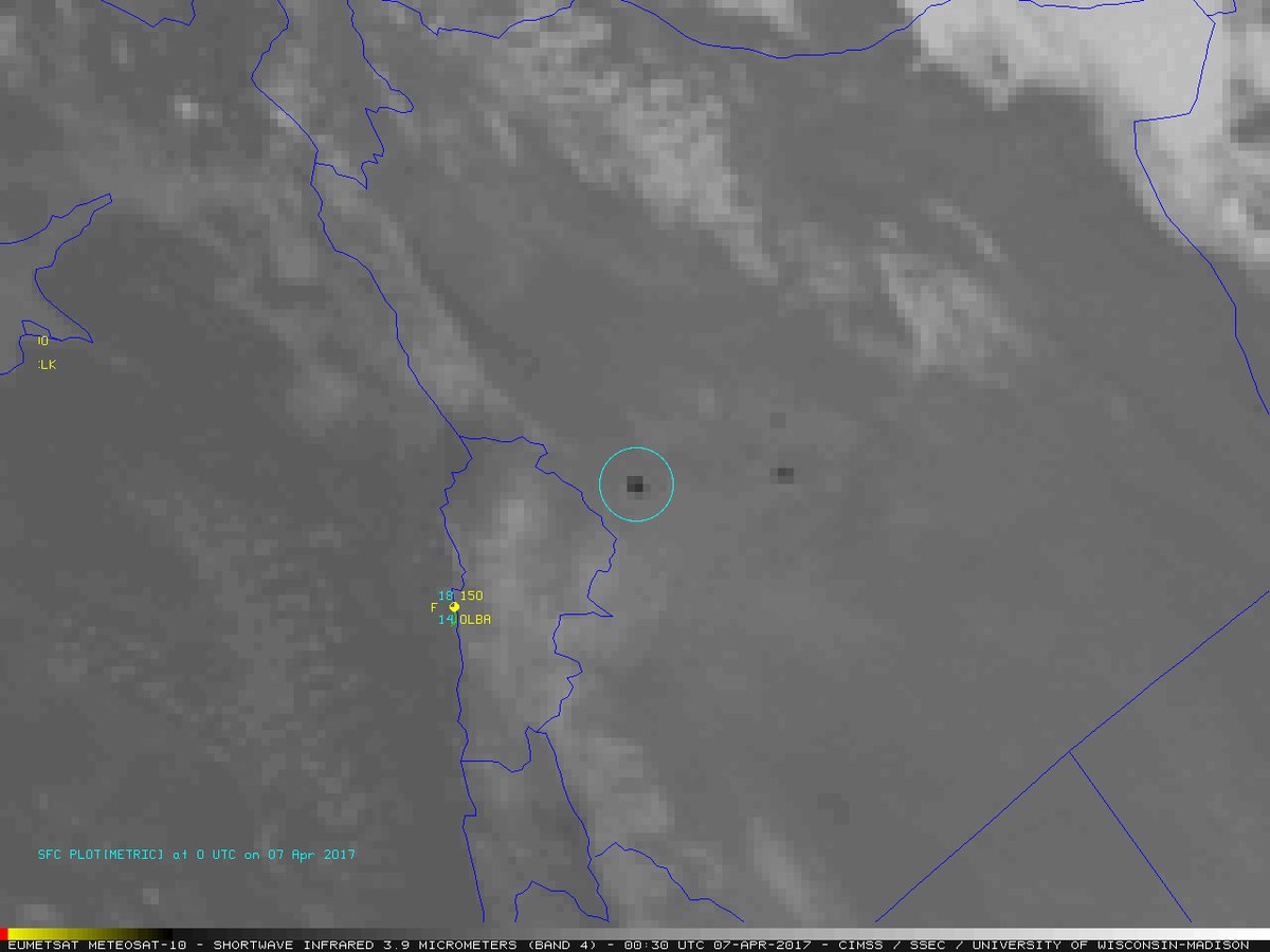
The European weather satellite constellation, Meteosat, captured the heat signature of the US’s response to a recent gas attack launched by Syria on its people.

Battle damage assessment image of Shayrat Airfield, Syria, is seen in this DigitalGlobe satellite image, released by the Pentagon following U.S. Tomahawk Land Attack Missile strikes from Arleigh Burke-class guided-missile destroyers, the USS Ross and USS Porter on April 7, 2017. DigitalGlobe/Courtesy U.S. Department of Defense/Handout via REUTERS ATTENTION EDITORS - THIS IMAGE WAS PROVIDED BY A THIRD PARTY. EDITORIAL USE ONLY. NO RESALES. NO ARCHIVE. MANDATORY CREDIT.
Battle damage assessment image of Shayrat Airfield, Syria, is seen in this DigitalGlobe satellite image, released by the Pentagon following U.S. Tomahawk Land Attack Missile strikes from Arleigh Burke-class guided-missile destroyers, the USS Ross and USS Porter on April 7, 2017. DigitalGlobe/Courtesy U.S. Department of Defense/Handout via Reuters

In geostationary orbit at about 22,300 miles above the Equator, the Meteosat satellites operate over Europe, Africa and the Indian Ocean. There are 5 satellites in orbit; one is in “storage” and the other 4 are active in operation. Meteosat-10 was launched from the Guiana Space Centre in Kourou in 2012. It is the prime operational geostationary satellite, positioned at 0 degrees and providing full disc imagery of the Earth every 15 minutes. Meteosat-9, launched in 2005, provides the Rapid Scanning Service, delivering more frequent images every five minutes over parts of Europe, Africa and adjacent seas. Meteosat-8, launched in 2002, operates over the Indian Ocean.  The satellite in storage, Meteosat-11, was launched in 2015; it will remain in orbit and not used unless another Meteosat satellite fails.


The weather satellite, like those over the US, captures images of the atmosphere using both visible and infrared camera technology. Beyond detecting the temperature of cloud tops, such satellites can also pick up other types of hot and cold objects in the atmosphere or the ground. In this case, the Meteosat satellite was able to pick up the heat from the explosion created by the US military strike in Sryia.

Battle damage assessment image of Shayrat Airfield, Syria, is seen in this DigitalGlobe satellite image, released by the Pentagon following U.S. Tomahawk Land Attack Missile strikes from Arleigh Burke-class guided-missile destroyers, the USS Ross and USS Porter on April 7, 2017. DigitalGlobe/Courtesy U.S. Department of Defense/Handout via REUTERS ATTENTION EDITORS - THIS IMAGE WAS PROVIDED BY A THIRD PARTY. EDITORIAL USE ONLY. NO RESALES. NO ARCHIVE. MANDATORY CREDIT.
Battle damage assessment image of Shayrat Airfield, Syria, is seen in this DigitalGlobe satellite image, released by the Pentagon following U.S. Tomahawk Land Attack Missile strikes from Arleigh Burke-class guided-missile destroyers, the USS Ross and USS Porter on April 7, 2017. DigitalGlobe/Courtesy U.S. Department of Defense/Handout via Reuters

The United States launched a military strike on Thursday on a Syrian government airbase in response to a chemical weapons attack that killed dozens of civilians earlier in the week. On President Donald Trump’s orders, US warships launched 59 Tomahawk cruise missiles at the airbase that was home to the warplanes that carried out the chemical attacks, US officials said.

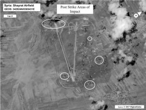
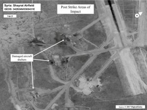
Other satellites were able to capture the view on the ground after the US response was complete. The Pentagon released images captured by DigitalGlobe that shows damage at the Shayrat Airfield in Syria.


DigitalGlobe is a leading global provider of commercial high resolution earth imagery products and services. Their satellite photography supports a wide variety of uses, such as defense and intelligence initiatives, mapping and analysis, environmental monitoring, oil and gas exploration, and infrastructure management.


Primary Sidebar

Sponsored Ad

Search

Latest News

  • Soviet Union Spacecraft Crash Zones Updated; NJ/NY/PA/MI at Increased Risk
  • Over 2,000 People Report Shaking from Virginia Earthquake
  • Morning Earthquake Strikes Heart of New Madrid Seismic Zone in Missouri Today
  • New York TV Weatherman Back After Brain Injury
  • NASA Monitoring Significant Magnetic Anomaly over Atlantic
  • Out of Control Soviet Union Spacecraft Could Crash Into Your House This Week
  • Elevated Tornado Threat in New Jersey, Pennsylvania, and New York
  • Significant Severe Weather Outbreak Likely Today
About | Careers | Contact | Contests
Terms | Privacy | Ad Choices
Weatherboy is a (R) Registered Trademark of isarithm LLC, All Rights Reserved.
All content herein is Copyright by Isarithm LLC 1997-2022