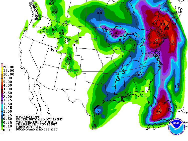
A potent area of low pressure is forecast to form in time for the weekend, bringing a coastal storm threat to the Northeast. While some questions remain with forecast specifics, it appears the Mid Atlantic and Northeast will be visited by a very wet and windy storm system beginning Sunday morning. The system, as it slides off the coast, should rapidly intensify, increasing the intensity of the winds and the rains in the northeast by Sunday evening. A slowly advanced deep trough moving through the central and eastern US late this week is responsible for the storm. This trough allows for a poleward jaunt of a weak tropical system in the western Caribbean responsible for heavy rains in portions of Cuba and Central America. This weak surface low moves very rapidly Saturday afternoon through Sunday night, from the northwest Caribbean to somewhere off the East Coast. Computer guidance that meteorologists use to help forecast the weather suggests a predecessor surface low will develop along a cold front approaching the Mid Atlantic coast too; i t is this predecessor low that will likely be the main culprit for the stormy weather Sunday and Sunday night.
As the trough acquires negative tilting, this predecessor low may rapidly deepen Sunday afternoon and evening, inducing a strong surface pressure gradient. With a strong surface pressure gradient, howling winds are likely, especially at the coast. As the low races northward Sunday night, winds will turn westerly and then northwesterly and will increase rapidly.
Wet and windy weather is coming, but some questions remain with timing and track and how these pieces, such as the tropical disturbance in the Caribbean, the approaching cold front, the slow moving trough, and the predecessor low all work together or not, and when. At this time, it appears the pieces will come together as the core of the storm slides east of New Jersey, setting the state of primary impacts over New England. However, it is possible this transformation could occur a bit earlier or later, which would lead to a larger area of heavy rain and strong winds on Sunday. For now, it appears generally 2″+ rain will fall over Delaware, Maryland, eastern West Virginia, northern Virginia, central and eastern Pennsylvania, New Jersey, and all points north and east. Within this area, 3-5″ could fall, with some of the heavier totals possible over eastern Upstate New York and Maine. Again, shifts in timing or the evolution of the storm ingredients may shift the heavier rain areas further north/south or west/east.
Heavy precipitation will linger into Monday across northern New England while the rest of the Northeast and Mid Atlantic dry out. As colder air wraps around behind the system, some rain may end as snow showers over western Maine late Monday. However, no significant snowfall accumulations are expected at this time.