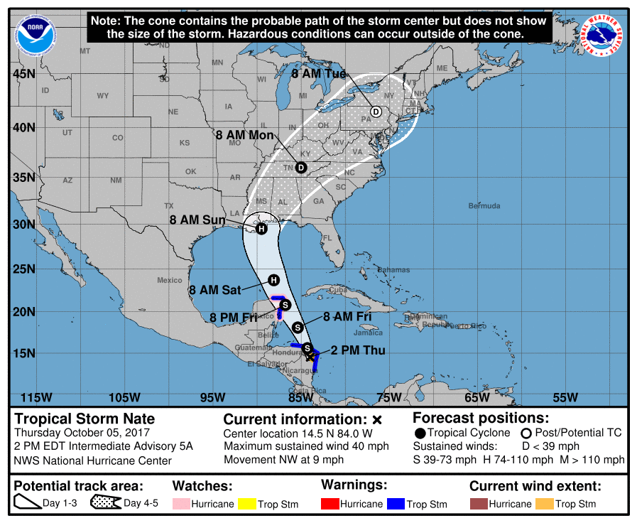
Earlier today, the National Hurricane Center (NHC) upgraded Tropical Depression #16 to Tropical Storm Nate; it is expected to gain strength to hurricane status and eventually make a US landfall this coming weekend. As of the 2pm ET advisory from the NHC, the center of Tropical Storm Nate was located inland over northeastern Nicaragua near latitude 14.5 North, longitude 84.0 West. Nate is moving toward the northwest near 9 mph. A turn toward the north-northwest at a faster forward speed is expected this afternoon or tonight, with that motion continuing through Friday night. On the forecast track, the center of Nate should move across northeastern Nicaragua and eastern Honduras this afternoon and then over the northwestern Caribbean Sea tonight and Friday. The center is expected to approach the coast of the Yucatan Peninsula late Friday. Maximum sustained winds are near 40 mph with higher gusts. Little change in strength is expected today while the center is over land. Strengthening is likely once the center moves over the northwestern Caribbean Sea tonight and Friday. Tropical-storm-force winds extend outward up to 50 miles mainly over water to the east of the center. The estimated minimum central pressure is 1001 mb (29.56 inches).

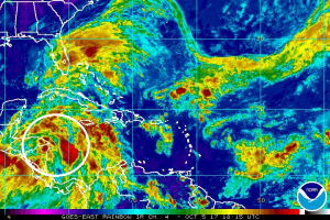
While Nate’s circulation is being impacted by land, it has increased in organization in the time since the prior advisory from the NHC. There’s a formation of a ragged central convective feature and outer banding in the northeastern semicircle. According to the NHC, data from the Colombian radar at San Andres showed a partial eyewall, and surface observations from Puerto Cabezas, Nicaragua, included a pressure of 1001 mb outside of the center.
Many questions remain about Nate’s future. The center of Nate is now inland over northeastern Nicaragua and little change in strength is expected until the center moves over the northwestern Caribbean Sea. After that, a combination of warm sea surface temperatures and light shear should allow for at least steady strengthening. However, forecast model guidance is producing mixed signals despite a favorable-looking environment. The Rapid Intensification Index of the SHIPS model is showing high chances of rapid intensification, with better than a 50 percent chance of 25kt of strengthening in the next 24 hours and nearly a 50 percent chance of 65 kt of strengthening in 72 hours. On the other side, the American GFS and Canadian models show only modest development and keep the cyclone as a tropical storm until it reaches the northern Gulf coast. Given the environment, the intensity forecast from the NHC leans towards the high end of the guidance envelope and calls for Nate to become a hurricane in about 48 hours and reach the northern Gulf Coast as a hurricane.

A combination of a large cyclonic gyre over Central America, a trough of low pressure moving westward across the Gulf of Mexico, and a building subtropical ridge over the western Atlantic should steer Nate generally north-northwestward with an increase in forward speed during the next 2-3 days. While the guidance is in better agreement on the direction that Nate should move, there remains disagreement on the speed despite an overall trend toward a faster motion. The latest NHC forecast track is similar to the direction of the previous track, but shows a faster forward speed that has the center near the northeastern Yucatan Peninsula in about 36 hours and near the northern Gulf Coast in about 72 hours.
It is still too early to say with certainty where Nate will strike the coast. Yesterday, Florida’s Panhandle appeared to be the target zone; new forecast model guidance today suggests New Orleans and the Louisiana coast will be under the gun. We expect some changes east and west with the track guidance until Nate enters the central Gulf of Mexico. By then, it should become nearly certain where the hurricane will strike. Until that certainty exists, residents across the central Gulf coast, especially from Louisiana to Florida, should closely monitor this storm and make sure their Hurricane Action Plan is in order. It is becoming likely that someone in this region will need to act on the plan before the weekend.
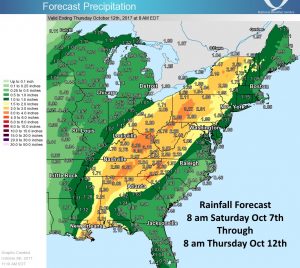
After the Gulf Coast landfall, Nate or its remnants are expected to recurve northeastward upon encountering the mid-latitude westerlies. Nate’s remants will bring heavy rains well north and east into the Ohio River Valley and western New England. Beyond the landfall threat area, residents up and down much of the eastern US should remain cautious of flooding threats due to Nate’s heavy rains.
The National Hurricane Center wants these three key messages shared:
- Heavy rainfall is the main threat from Nate in portions of Central America, with life-threatening flash flooding and mud slides possible in portions of Nicaragua, Honduras, Costa Rica, Panama, and Belize through Friday night.
- Nate is forecast to be near hurricane intensity when it approaches the Yucatan Peninsula late Friday, bringing direct impacts from wind, storm surge, and heavy rainfall. A tropical storm warning and a hurricane watch are in effect for a portion of this area and life-threatening flash flooding is also possible.
- Nate is forecast to reach the northern Gulf Coast this weekend as a hurricane, and the threat of direct impacts from wind, storm surge, and heavy rainfall is increasing. However, it is too early to specify the exact timing, location, or magnitude of these impacts. Residents along the Gulf Coast from Louisiana through the Florida Panhandle should monitor the progress of Nate and heed any advice given by local officials.