A question on many’s mind this weekend is about the weather for next weekend: will there be some type of super storm in time for the Super Bowl in the northeast? Computer model forecast guidance has been providing meteorologists with very conflicting information about whether or not a storm will form, and if it does form, where will it go.
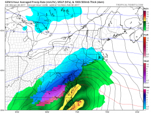
Ingredients from the north and the south are necessary to come together to create a big eastern winter storm. Unlike the high pressure ridge that brought up unusually mild conditions up the eastern United States, a trough of low pressure is being carved out over the upper levels of the atmosphere of the Great Lakes region. Rather than transporting mild and generally wet weather up the East Coast, the trough will bring down cold and generally dry air from central Canada into the Northeast. Air originating over central Canada is a dry continental air mass, starved for moisture since there are no open oceans to tap moisture from there. As cold air pushes down into the Northeast and Mid Atlantic, most weather systems produce very little in the way of precipitation because they’re starved for moisture. The exception is the area down-wind of the Great Lakes; as that cold, dry air flows across them and picks up lake moisture as a result, Lake Effect Snow falls in the direction of the air flow. To get a robust winter storm with heavy precipitation, typically this northern “stream” of air from Canada needs to meet-up with energy and moisture from a southern “stream” from the southern United States, the Gulf of Mexico coast, or the US southeast coast.
Forecast guidance is in agreement that the cold air and the northern stream will be present; however, they dispute the existence or position of southern stream energy that could “phase” with the northern stream. Some guidance, especially data that was produced early Friday, suggested that the southern energy would be far enough along to meet-up with its northern counterpart and produce a significant snowstorm in the Mid Atlantic and New England regions. The same models have backed-off the idea, suggesting the northern stream will be so potent that it’ll suppress any activity in the south from phasing with it …or suggesting that such a phase would happen too soon or too late to create the situation that would foster a snowstorm.
Computer-generated forecast guidance is one of many tools that meteorologists use to develop their weather forecasts. While forecast guidance has been extremely inconsistent with each other or with itself run-to-run, the overall pattern change and climatological set-up does favor more a winter storm scenario than it doesn’t. Still, the right ingredients need to come together at the right time to create a significant storm, and the computer generated forecast guidance is making many loud, but early, hints that those ingredients may not all be there when they need to be.
Should a storm system form along the East Coast, it appears the best time for that to happen would be late Sunday. Wintry precipitation is unlikely in the Mid Atlantic prior to the kick-off of the Super Bowl Sunday evening. The threat of wintry precipitation arrives by midnight for the Washington, DC and Baltimore, MD areas and later in the early morning hours Monday further up the coast for places like Philadelphia and New York. This could change as we understand the overall flow across the country and the timing of northern and southern stream components, but the best chance of the most precipitation is Monday from this next potential storm.
Prior to this storm threat for next weekend, we are monitoring the potential for weaker systems beforehand. But because they aren’t tapping into southern stream energy and moisture, any such system that moves through the northeastern quarter of the country will be light. The exception, of course, will be down-wind of the Great Lakes where the Lakes are able to offer up additional moisture to very localized areas to support heavier snow.
