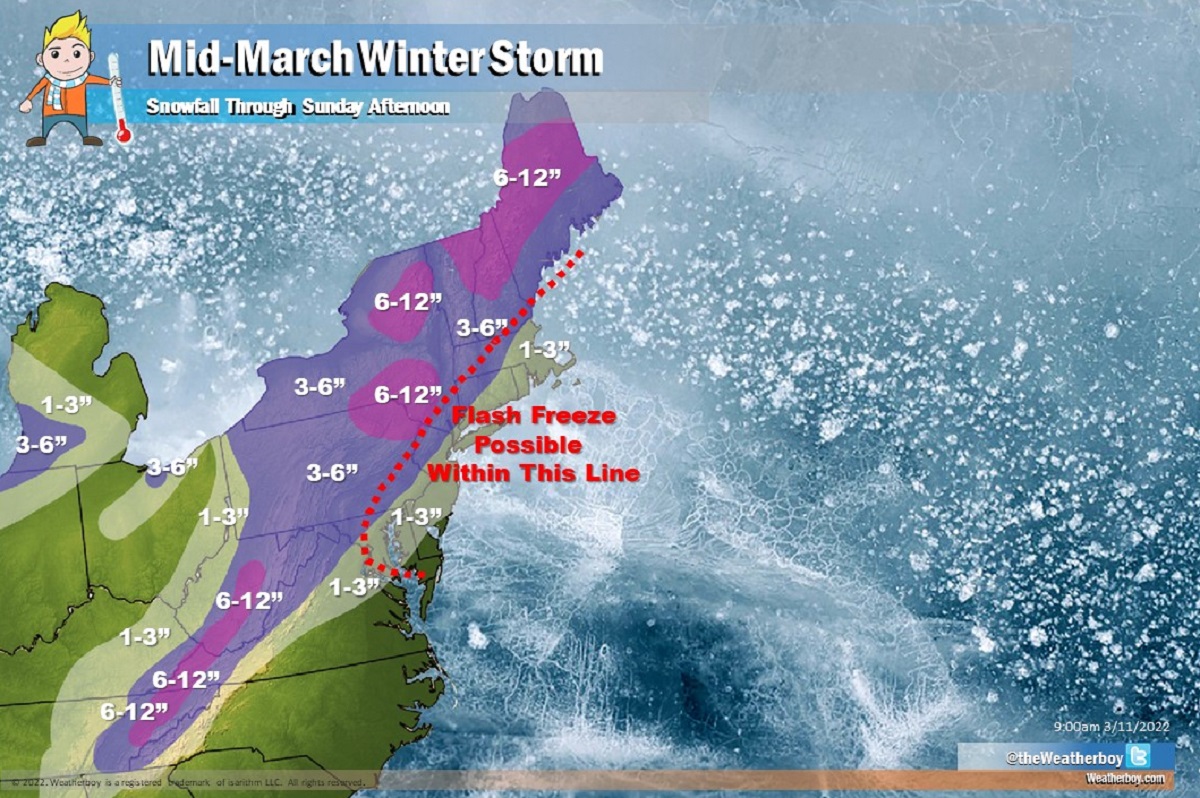
A significant winter storm is expected tomorrow, bringing up to a foot of heavy snow to portions of the northeast. Beyond the threat of heavy snow, there is also a growing risk of a flash freeze along the I-95 corridor, with the greatest threat between Philadelphia, PA and Boston, MA. While this is a winter storm, there will be spring-like characteristics with it: strong winds and severe thunderstorms are also possible on the southern side of this storm.
Before the storm hits the northeast tonight, a weak high pressure system will be in control. With the high in place, today will be the quiet before the storm: conditions will be a quiet and pleasant day across much of the I-95 corridor with temperatures at or above normal levels for this time of year. Mid and high level clouds will increase late in the day as the winter storm takes shape to the west.
A phasing of northern and southern stream troughs over the Great Lakes region will spur cyclogenesis over the Southeast tonight. This low is expected to rapidly intensify as it moves northeast late tonight and early tomorrow. The primary surface low will track right through the I-95 corridor, bringing up milder, moist air from the south on its eastern side while cold northwest winds wrap around on its backside.
A surge of moderate to heavy rain will move up the east coast late Friday night into Saturday morning, with rainfall amounts of 0.75-1.0″ expected. Some locations could see rainfall amounts double that, especially in thunderstorms that could fire-up near the frontal passage associated with the system. Cold air will be locked in place across northern New England to produce only snow from this system; to the south, rain will change over to snow as the cold air wraps around behind the storm.
The expected fast drop in temperatures could create a flash freeze situation in which wet surfaces instantly freeze; this could be extremely dangerous on untreated roadways and sidewalks.
While the heaviest snow will fall north and west of the I-95 corridor, rain is expected to change to snow even at the coast as far south as Delaware. A quick 1-3″ is even possible in places like Philadelphia, New York City, and Boston with much more north and west. Snowfall amounts should max out around a foot in the higher terrain of eastern Pennsylvania, eastern Upstate New York, and interior New England.
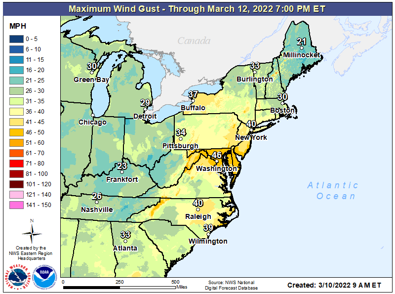
This will be a very windy storm as the low pressure “bombs-out” over the northeast. As the pressure drops dramatically, winds will increase through much of the East. Wind gusts to and over 40m mph are possible, with the strongest winds expected late Friday into the middle of Saturday. Gusts approaching 60 mph may be strong enough to do tree damage and knock down power lines resulting in power outages.
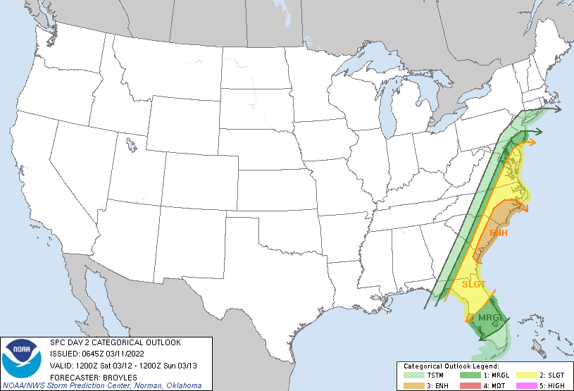
In addition to strong wind gusts that could create some damage, there is also the risk of severe weather from this storm from the Mid Atlantic south. Right now, the National Weather Service’s Storm Prediction Center believes the greatest threat of severe weather from this winter storm will be across southeastern Virginia, eastern North and South Carolina, southeastern Georgia, and the northern half of Florida excluding the panhandle. Thunderstorms are possible anywhere from New York south to Florida; in this area, some storms can help mix stronger winds above the surface down to the surface, leading to isolated damage issues. The greatest risk of severe storms is from southern New Jersey into northern Florida; the coast of the Carolinas has the highest odds of seeing severe thunderstorms and isolated tornadoes.
The storm will rapidly pull out of the area later Saturday with only flurries lingering over northern New England on Sunday in the storm’s wake. High pressure will return again, allowing the eastern U.S. to recover from yet another mid-March winter storm.
