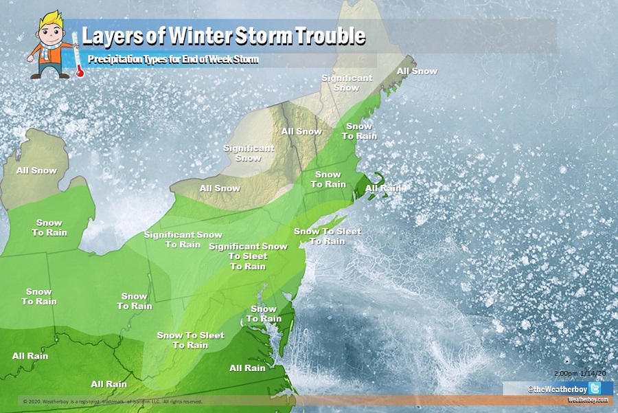
A complex area of low pressure will push into the northeast at the end of the week, bringing about layers of wintry weather mess to the heavily populated region. Significant snow, sleet, rain, and a mix of all three will enter the region, leaving some with a slushy, icy mess and others with hefty snowfall amounts.
An upper trough sliding from the Rockies to the Northeast will develop a significant low in the lee of the Rockies, which will tracks across the Plains and Midwest Friday and Saturday and into New England by Sunday. As this storm system slides across the Great Lakes region, a secondary system will form along the northeast coast. The timing and intensity of that second system will help determine who gets what kind of precipitation from this area of low pressure. While a cold-front moving through this area will keep temperatures cold enough for precipitation to start as snow from Washington, DC north, a substantial southerly flow component to the storm will surge milder air up the coast, turning that snow to sleet and possibly freezing rain before changing it to plain rain in places. That secondary low pressure system on the coast will help tame that southerly flow and could lock in colder air longer, producing heavier snow before a change-over or producing more sleet than rain when a changeover finally does occur. Due to the complexity of the set-up, there will be different layers of wintry mess possible throughout the northeast.
As an example, the relatively small state of New Jersey will see a bit of everything. The extreme northwest corner will see significant snow eventually changing to some rain towards the end of the system while the extreme southeast tip of Cape May County will see only plain rain. In the rest of southern New Jersey, the system will start out as snow but change over to plain rain. Further north into central New Jersey, including the Philadelphia and New York City metro areas, the snow will change to sleet with perhaps some freezing rain mixed in; the mixed precipitation will eventually change-over to plain rain. But just north of there, there could be significant snow accumulations before it too changes over to sleet and plain rain. In the end, it’s possible for northern New Jersey to see over 6″ of snow before a change-over occurs while Cape May County will be left with no accumulation by the time the storm is done.
Similar messy layers will set-up elsewhere throughout the northeast. Pittsburgh, PA, Washington, DC, and Boston, MA will all see snow changing to rain from this system.
However, north of this mixed precipitation area, plain snow should fall. Only snow is expected across northern Michigan, northern Upstate New York, the northern half of Vermont and New Hampshire, and northern Maine. In portions of New York, Vermont, New Hampshire, and Maine, the snow could be heavy at times; accumulations may approach or exceed a foot by the time the storm is done.
The storm system responsible for this mixed bag will eventually move away on Sunday, with colder, drier air arriving on gusty northwest winds moving into the region.
