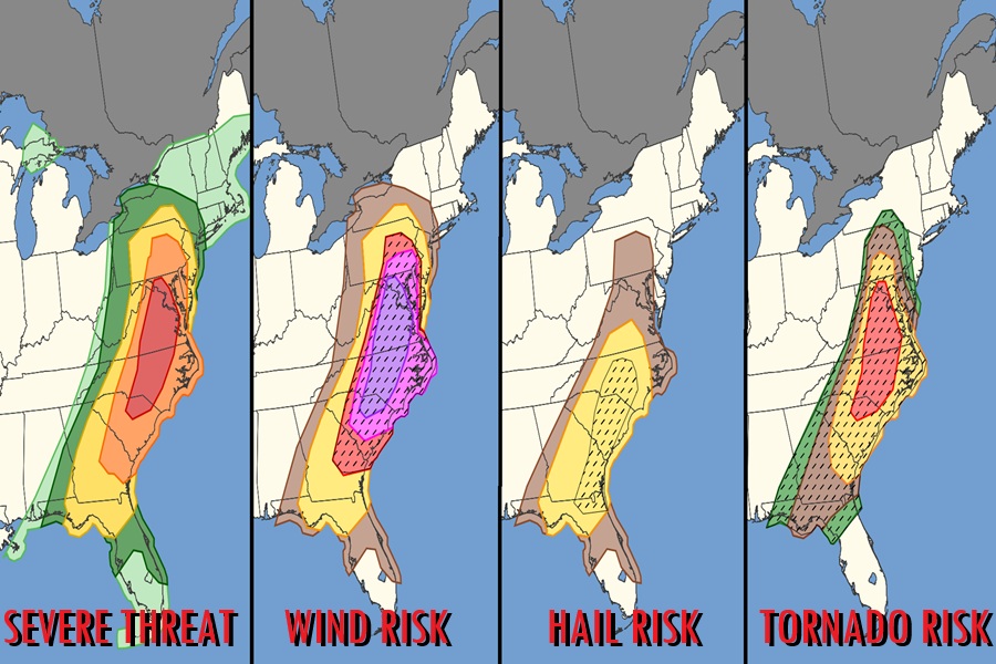
A severe weather outbreak is likely to unfold across a large portion of the U.S. East Coast on Monday. Severe thunderstorms with flooding rains, frequent lightning, damaging wind gusts, large hail, and tornadoes are all possible in this outbreak, with the most severe weather likely to strike from central Pennsylvania south into central Georgia. Tornadoes, some strong, and particularly damaging winds are most likely from parts of South Carolina to Maryland during the afternoon.
An expansive upper trough from Wisconsin to the Ark-La-Tex will further amplify as the surface low pivots rapidly northeastward towards the Appalachians. A deep surface cyclone over Lower Michigan will progress into Quebec, with an occluded front arcing southward to a minor low over western to central New York by Monday afternoon. A sharp cold front will extend south of this low across the Southeast into the northeast Gulf, sweeping east across the entire Atlantic Seaboard early Tuesday morning.

This type of meteorological set-up lends itself to three distinct periods of poor weather. The first part will be heavy rain moving north tonight into early tomorrow, threatening cities with the risk of urban flooding. As the farm front moves to the north, some sunshine should come out which will help destabilize the atmosphere in portions of the Mid Atlantic. With the atmosphere destabilized from afternoon heating from that sunshine, thunderstorms will be able to rapidly grow and intensity, setting the stage for frequent lightning, flash flooding rains, and the threat of damaging wind gusts and tornadoes. The third distinct part of this storm should be a well defined squall line that should sweep to the coast as a cold front advances east. While this cold front will bring an end to the precipitation once it clears, it could be quite rough as it passes through with a squall line of intense thunderstorms, destructive straight-line winds, and the risk of hail.
“The downstream environment will already be favorable for supercells including strong tornado potential,” the Storm Prediction Center at NOAA warns. “Any semi-discrete supercells in this environment will have the potential to produce a strong tornado and large hail through early afternoon before large-scale outflow likely shifts offshore of the Georgia/north Florida coast.
The cold frontal passage will be significant, with much colder air arriving behind it. While accumulations aren’t expected, snow flurries and snow showers are possible as far east as eastern Pennsylvania, northwestern New Jersey, and eastern Upstate New York.
Curious about severe weather timing for tonight into tomorrow? https://t.co/0XLKoCeERw
— the Weatherboy (@theWeatherboy) March 15, 2026
