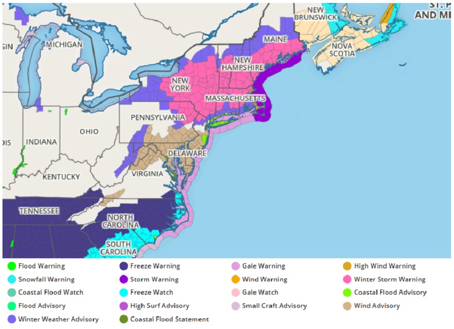
The National Weather Service has been issuing a variety of warnings and advisories for the northeast as a classic nor’easter takes shape there; Winter Storm Warnings are up from northern New Jersey to southeastern Maine while Wind Advisories are in effect for much of Maryland, New Jersey, Delaware, and portions of Pennsylvania and Virginia. At the coast, Coastal Flood Warnings are up for portions of New Jersey, Connecticut, and New York’s Long Island while Gale and Storm Warnings are also up for off-shore waters.
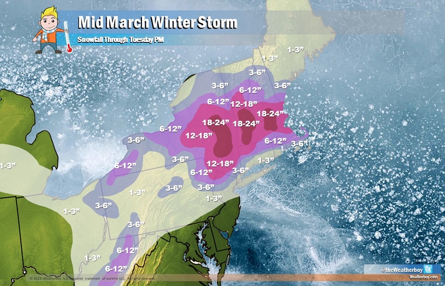
A surface low pressure system that was just off the North Carolina coast this afternoon is now intensifying and will continue to do so tomorrow as it pushes toward southeast New England by tomorrow. Heavy snows will be developing tonight to the north and northwest of this storm, with widespread heavy snow totals in the 6 to 18 inch range likely from northeast Pennsylvania/far northwest New Jersey, through much of New York state and much of New England, with isolated totals in
excess of 2 feet possible. In addition to the heavy snows, winds will be increasing in response to the rapidly strengthening low, with gusts in excess of 50 mph likely. The combination of high winds and snowfall rates of as high as 2 to 3 inches per hour will make for dangerous to impossible travel conditions during the day on Tuesday. These high winds will also produce widespread minor beach erosion and flooding from along the New England and southern New York state coastal region. By Wednesday the, storm is expected to begin to inch away from the New England coast, with some improvement likely for the clean-up, recovery and dig out.
The 30th anniversary of the Superstorm of ’93 is here. Who remembers this storm? pic.twitter.com/h4ipJOvqTi
— the Weatherboy (@theWeatherboy) March 12, 2023
This latest nor’easter is impacting the northeast on the 30th anniversary of the Superstorm of ’93, a potent winter storm that brought heavy snow from the Gulf Coast of Alabama all the way up to Maine. While today’s storm is significant, it isn’t nearly as significant as that other east coast storm three decades ago.
