A vigorous storm system will blast the northeast with significantly colder air, strong and potentially damaging wind gusts, and the threat of accumulating snow this weekend.
A strengthening low pressure system will move from the central Rockies into the Great Plains this afternoon. Snow from this system that is falling over the Rockies today will spread east into the Plains this afternoon. While rain will fall initially for many areas across the central/northern Plains and Upper Midwest, precipitation will change to snow from west to east as colder air wraps around the western side of the low pressure system.
By Friday morning, a heavy snow band is expected to set-up from the Northern Plains to the Upper Midwest. A strong pressure gradient around this intensifying storm system will bring strong, gusty winds to the region, setting the stage for blizzard conditions for some.
By later tomorrow night into Saturday morning, the low pressure system will be moving northeastward across the upper Great Lakes, with snow continuing on the northwestern side of the system. Farther south, in the warm sector of the frontal system, showers and thunderstorms will be possible ahead of the cold front tonight and Friday from the lower Mississippi valley to the Ohio valley. Conditions will be quite warm in this warm sector, with unseasonable warmth stretching north into Pennsylvania, New York, and New Jersey.
As the storm system slashes through that milder air and the pressure gradient tightens, cold air will race into the Northeast and Mid Atlantic on Saturday on very strong gusty winds. Winds may gust in the 40-65mph range which could cause some damage, especially on Sunday.
On the back bays in New Jersey, people there should also watch out for blow-out tides on Sunday and Monday morning.
Precipitation will push into the northeast. While heavy snow and blizzard conditions will be confined to the Upper Midwest, snow shower activity will move into the northeast along with rain showers on the southern side of the precipitation shield.
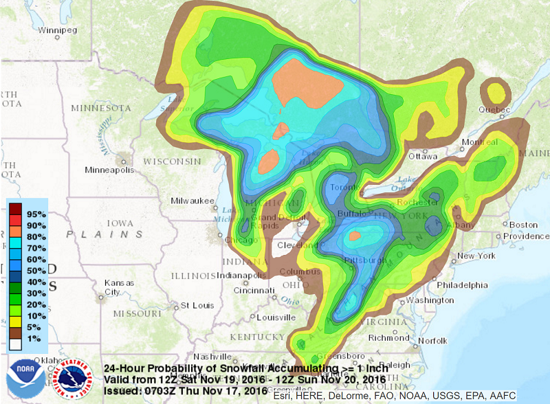
The National Weather Service developed a map that shows the probability of 1″ or more of snow falling across the northeast from Saturday morning to Sunday morning. The greatest chance of accumulating snow will be over western and northern Pennsylvania, the highest elevations of West Virginia, the higher elevations of upstate New York, and northern Vermont and New Hampshire.
But as cold air mixes down even on the eastern and southern sides of the storm in places like Philadelphia, Toms River, and New York City, snow flakes could fly on their own or be mixed with the rain. However, no accumulating snow of any kind is expected along and south or east the I-95 corridor from Washington to New York.
While snow won’t fall at the coast, it’ll feel significantly colder Monday than it does on Friday. Temperatures in this region should plunge 20 degrees for daytime highs with overnight lows falling well below the freezing mark for many locations. You can see our forecast for your local area here.
