A wintry mess is likely to unfold over the next several days with snow, sleet, freezing rain, and plain rain pushing east and north, bringing heavy snow to some one day and plain rain just a day or two later. With a wintry mess setting up, the National Weather Service has issued Winter Storm Warnings and Winter Weather Advisories for a large part of the Mid Atlantic.
A very active weather pattern will continue across much of the country, bringing round after round of precipitation to the northeast. Precipitation will become increasingly widespread early Tuesday from eastern portions of the Southern Plains into the lower Mississippi Valley as the lead storm system in the active weather pattern begins to develop. This organized precipitation will then spread quickly east northeastward during Tuesday across the Tennessee Valley, Southern to Central Appalachians and Mid-Atlantic.
Heavy snows are possible on the northern portion of the precipitation area from the Middle to Upper Ohio Valley, Central Appalachians and Mid-Atlantic, where snow totals of 6″ or more are possible. In addition to the snow, significant icing is possible across portions of the Central Appalachians from western North Carolina into Southwest to south central Virginia and far southeast West Virginia. Across these areas, the combination of the snow and ice
will produce difficult and dangerous traveling conditions.
Heavy rains, flash and river flooding will also be a threat with this lead storm across areas to the south of the heavy snow and ice threat. Flood watches are currently in effect across portions of south central to southeast Kentucky where recent rains have resulted in saturated soils and high stream flows. The threat of heavy rain from this lead system on Tuesday and additional heavy rains on Wednesday associated with asecond storm will increase the risk of life threatening flash and river flooding.
As the lead storm is affecting the Upper Ohio Valley, Tennessee Valley, Southern to Central Appalachians and Mid-Atlantic, a second storm, nicknamed storm # 2, will begin to form across eastern Texas Wednesday. This storm will support an increasing area of heavy snows across the Central Plains into the Middle Mississippi Valley Wednesday, Mid-West and Great Lakes region Wednesday evening and night, and into the Northeast and New England on Thursday.
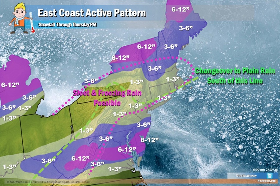
Unlike the first storm which will bring significant snow to the Mid Atlantic, this second storm will help surge milder air up into the northeast, bringing rain to the area getting heavy snow tomorrow into Wednesday on Thursday. Areas in the northeast not getting much snow from the Tuesday/Wednesday storm, though, should see significant snow from the second storm as colder air will be tougher to erode there, especially over Northern New England.
However, areas farther to the south across the remainder of New England and Upstate New York will see less snow totals as the snow may mix with sleet and freezing rain.
Similar to the lead system, the southern end of the precipitation associated with storm # 2 will bring heavy rain, flash and river flooding threats Tuesday and Wednesday from eastern Texas, across northern Louisiana, southeast Arkansas, large sections of Mississippi, northern Alabama, northern Georgia, eastern Tennessee, the Upstate of South Carolina and far western North Carolina. Widespread totals of 2-4″+ of rain are possible across these areas, with much of this region seeing heavy rains from both the first and second storm systems.
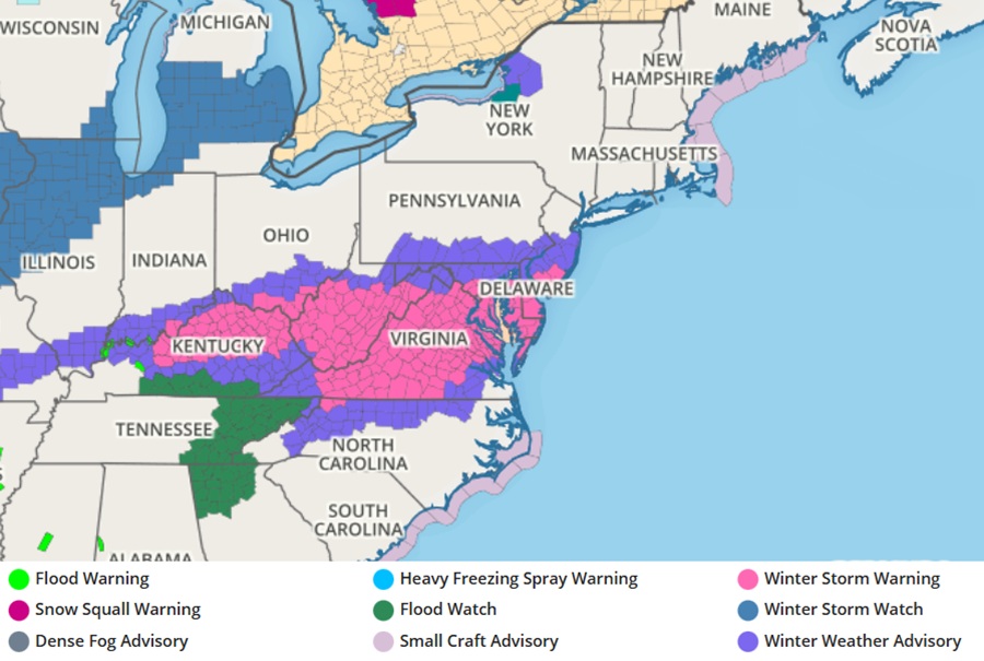
With heavy snow on the way with the first storm, the National Weather Service has issued Winter Storm Warnings in the area where 4-6 or more inches of snow are likely to fall across portions of southern New Jersey, much of Delaware, eastern Maryland, much of Virginia and West Virginia, and even portions of Ohio and Kentucky. North of the heavy snow area, Winter Weather Advisories are up where snow will make for slick driving conditions. Winter Weather Advisories are also up south of the Winter Storm Warning area where a mixed bag of precipitation could lead to hazardous travel conditions.
