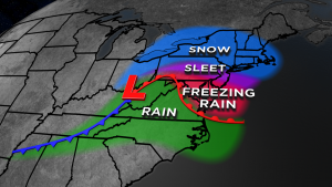
The changeover from snow to sleet, freezing rain or just plain rain will remain one of the biggest challenges in forecasting winter storms. It is a common occurrence along the east coast of the United States: warm moist air being pulled north into the cold arctic air moving south. It is a perfect setup for big snowstorms, but it also introduces warmer air that can quickly turn a heavy snow into sleet or freezing rain. Where you are in relation to a storm determines the precipitation type you see: snow, sleet, freezing rain, rain or all of the above. Where that storm develops can often determine how much warmth will be pulled into the storm. This in effect turns off the snow-making machine and leads to a whole new set of challenges for the forecaster and trouble for the public. Here’s a look at what makes conditions ripe for some big snow.
The Dendritic Growth Zone
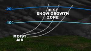
There are different types of snowflakes and the shapes they take on reflect the atmosphere they’re in. Some temperatures create small column-like structures while others create flat plate-like structures. When conditions are just right you get what is called a dendrite. The dendrite is your textbook big snowflake with complex designs and shapes. What makes the dendrite significant is that it can accumulate more given its complex design moreso than from different shape. The figure shows that dendrites form best when you have rising air that becomes very moist between -10 and -20 degrees Celsius. The prime temperatures are actually between -12 and -18 degrees but a forecaster will look for rising moist air through that region to determine where the big snows will fall. Once a snowflake melts, it is sleet or rain from then on.
A casual phrase is “fluff factor”; while meteorologists may cringe when they hear the phrase, the temperature and dryness of the air helps define the type of snow that’ll fall. It is true that very cold temperatures make for very fluffy snow. A fluffy snow may be cleared with a broom while a heavier wet snow will require a shovel. Extremely cold temperatures can make snow very light and dry. The colder the air gets, the less and less moisture it can hold , resulting in a quickly accumulating fluffy snow. When there’s more warmer air at play, the snow gets more wet and heavy.
Once a Snowflake Melts, it will either be Rain or Sleet
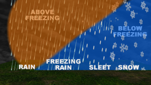
While a storm may create a perfect snow zone thousands of feet above the ground, it can also start bringing in warmer air just above the surface. Warmer air only becomes an issue if it is both above freezing and fairly moist so that a falling snowflake will melt and not evaporate. Big snowstorms are big because they are bringing in a lot of moisture, but with that moisture sometimes comes warmer air. If a snowflake falls through this warm layer and melts, it will continue to fall as a raindrop and will not be able to return to its initial snowflake form. Warm layers in storm can vary in size. If the air is below freezing all the way to the surface, snow will fall. If the melted snowflake travels through cold air well before it reaches the surface, the rain drop will freeze resulting in sleet or ice pellets. If there is only a shallow layer of cold air or if the surface itself is just below freezing, the precipitation will pass through the deep warm layer in liquid form but freeze upon contact with the ground as freezing rain.
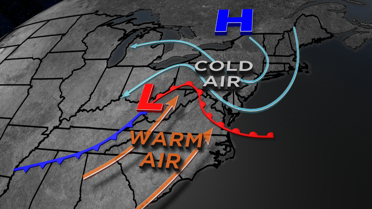
Cold air damming and significant sleet and ice.
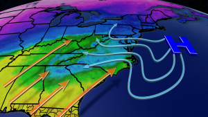
Often, a storm that wraps in the warm air in the atmosphere will eventually bring that warm air lower to the surface too At that points the roads become wet and the fresh snow turns to a slushy mess with the temperatures above freezing. In certain cases that warm air may take a little longer to move in at the surface or may never even make it at all. In these situations, rain may fall to a shallow area of freezing air that doesn’t budge, resulting in a prolonged, potentially crippling ice storm. There are a number of factors that can lead to these ice storm scenarios; while the weather pattern can play a role, nearby terrain and elevation often plays a significant role. One type of pattern is shown in the figure here and is called cold air damming. Prior to a storm developing, if a strong high pressure center with Arctic air is in place , it can trap the cold air in place between the Atlantic Ocean and the Appalachian Mountains. The cold air becomes trapped at the surface and can take a longer time to be pushed out. The longer it takes to move out , the worse an ice storm situation may be.
