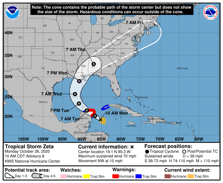
Zeta is just below hurricane strength about 120 miles southeast of Cozumel, Mexico now, but is expected to strike Mexico as a hurricane, enter the Gulf of Mexico, strike the U.S. Gulf Coast as a hurricane, and then move through the eastern United States as a potent tropical storm as it transitions to a post-tropical storm. Similar to Isaias that brought strong tropical storm conditions throughout New Jersey and portions of the Mid Atlantic far away from where it initially came ashore, Zeta too will have far-reaching impacts after its initial landfall too.
With maximum sustained winds of 70 mph, Zeta is just a few miles per hour shy of becoming a Category 1 hurricane. That is expected to happen soon with the National Hurricane Center in Miami, Florida officially calling for the storm to become a hurricane prior to striking Mexico’s Yucatan Peninsula. Some weakening is likely while Zeta moves over the Yucatan Peninsula tonight and early Tuesday, but Zeta is forecast to strengthen again while it moves over the southern Gulf of Mexico later on Tuesday. Zeta is forecast to make landfall on the coast of Louisiana late Wednesday as a hurricane and move into Mississippi, Alabama, and Florida as a strong tropical storm. From there, the system will merge with a frontal system moving through the southeast, bringing the threat of heavy rain, damaging winds, and isolated tornadoes across Tennessee, Georgia, North and South Carolina, Virginia, Maryland, Delaware, New Jersey, and New York over time. By early Friday morning, the center of what’s left of Zeta is expected to be just off the Jersey Shore, south of Long Island.
For now, a Hurricane Warning is in effect for Cozumel and from Tulum to Dzilam, Mexico. A Tropical Storm Warning is in effect for Pinar del Rio, Cuba, the area south of Tulum to Punta Allen in Mexico, and the area west of Dzilam to Progreso, Mexico. There are no watches or warnings up for the United States yet, but that is expected to change by tonight. A Hurricane Warning means that hurricane conditions are expected somewhere within the warning area. A warning is typically issued 36 hours before the anticipated first occurrence of tropical-storm- force winds, conditions that make outside preparations difficult or dangerous. Preparations to protect life and property should be rushed to completion. A Tropical Storm Warning means that tropical storm conditions are expected somewhere within the warning area within 36 hours.
Zeta will bring a potentially lethal storm surge, damaging winds, and flooding rains where it goes.
Hurricane conditions are expected within the Hurricane Warning area in the Yucatan Peninsula by late today. Tropical storm conditions are expected within the Tropical Storm Warning area in Mexico by late today. Tropical storm conditions could occur in the warning area in western Cuba beginning later today.
A dangerous storm surge will raise water levels by as much as 2-4′ above normal tide levels along the immediate coast in the Hurricane Warning area near and to the north of where the center makes landfall in the Yucatan Peninsula. There will likely be a storm surge threat to the U.S. Gulf Coast too; the National Hurricane Center is analyzing that threat and will describe potential impacts when it issues a Storm Surge Watch.
Rainfall totals of 4-8″ with local amounts of 12″ are possible through Tuesday along and east-northeast of Zeta’s track across the Yucatan Peninsula of Mexico, the Cayman Islands, and central to western Cuba. Heavy rains will begin to impact the central Gulf Coast Tuesday night, spreading inland across eastern Mississippi, Alabama, northern Georgia during Wednesday, through the southern Appalachians Wednesday night and into the Mid-Atlantic on Thursday. Rainfall totals of 2-4″ with isolated amounts of 6″ inches are expected across these areas, resulting in flash, urban, small stream, and minor river flooding.
As the storm eventually pulls off the Mid Atlantic Coast, it may be able to pull down just enough cold air from Canada to produce a heavy, wet snowfall in portions of the northeast on Friday. It is too soon to say with certainty where snow will fall or how much could fall.

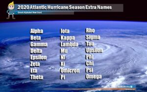
Zeta is going to become the 11th hurricane of the 2020 Atlantic hurricane season to date. Only 2 other Atlantic seasons on record since 1851 have had 11+ hurricanes by today’s date: 1950 and 2005. 2005 was also the only year on record that a storm with the name “Zeta” formed. It also appears Zeta won’t be the last storm of the 2020 Atlantic Hurricane Season which runs through the end of November; computer forecast guidance is already suggesting that a new tropical storm or hurricane could be nearby as soon as next week. Should that happen, it would be called “Eta”, the first time that Greek letter would be used to name a tropical cyclone.