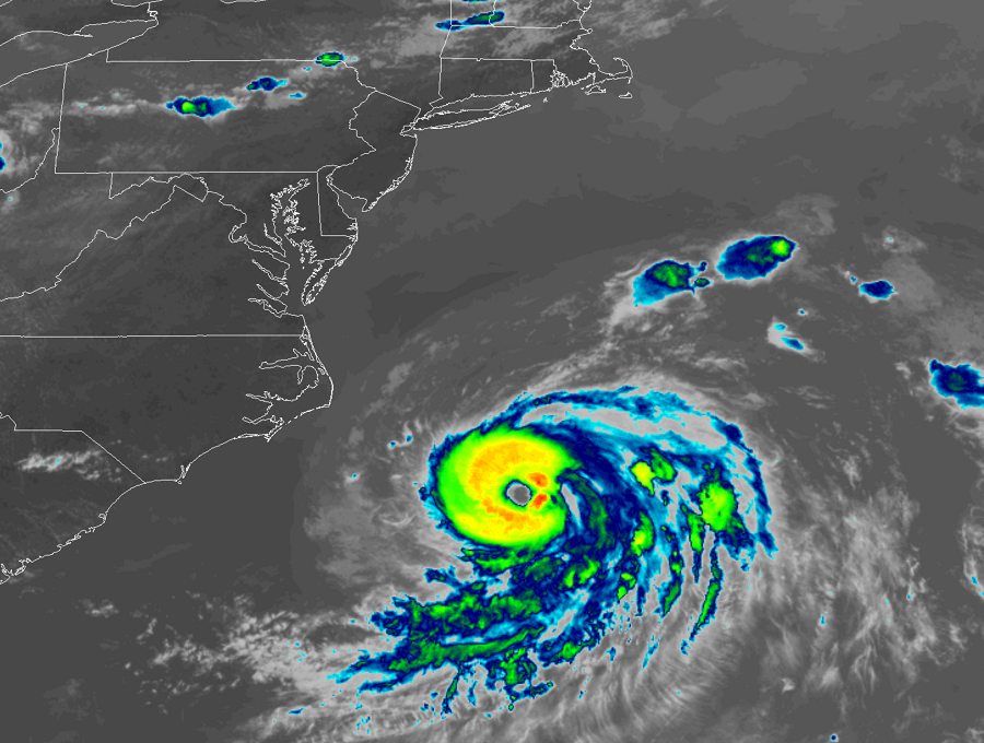
After reviewing reports from an Air Force Reserve hurricane hunter aircraft examining the storm, the National Hurricane Center has upgraded Tropical Storm Chris to Hurricane Chris this evening, making it the second hurricane thus far for the 2018 Atlantic Hurricane Season. The arrival of the second hurricane of the relatively young season, which began June 1, is about 6 weeks ahead of normal climatology. As of the latest advisory, Chris is located at 33.7N 72.4W, which is about 205 miles east southeast of Cape Hatteras, North Carolina. Maximum sustained winds are 85mph with higher gusts, making Chris a Category 1 hurricane on the Saffir-Simpson Scale. Minimum central pressure is at 980mb or 28.94″.
Fortunately, Chris is forecast by the National Hurricane Center (NHC) to gradually move away from the U.S. East Coast, parallelling it into the Canadian Maritimes. Chris is north of a narrow subtropical ridge, and water vapor imagery also indicates
that Chris is beginning to feel the influence of a digging trough over the northeastern U.S. and Mid-Atlantic states. The combination of these two features should gradually accelerate the hurricane northeastward at a faster forward speed through 96 hours. By the time Chris passes well southeast of Nova Scotia in 36 hours or so, the hurricane will be moving at a forward speed of more than 25 kt. On the new forecast track from the NHC, Chris is still expected to move near or over southeastern Newfoundland in about 48-60 hours.
Now that Chris has moved away from the cold upwelling region, some additional intensification is forecast for the next 12 hours or so due to 80-82 degree sea surface temperatures beneath the cyclone and the well-established current outflow pattern that is expected to persist during that time. Slow weakening should begin shortly after Chris peaks in intensity due to the cyclone moving over cooler waters, creating some modest upwelling as a result. In about 36 hours, the NHC believes Chris will have
moved well north of the Gulfstream and will be moving over colder sea surface temperatures. The combination of the much colder water and southwesterly vertical wind shear in excess of 30 kt should induce a rapid transition to an extratropical cyclone.
Because Chris is moving away from the United States, a previously scheduled aircraft mission into the hurricane has been cancelled.
While the storm won’t directly impact the U.S. East Coast with heavy rain and wind, there will be numerous hazardous indirect impacts. Hazards including rough surf, rip currents, beach erosion, and localized coastal flooding, especially at times of high tide, are possible from North Carolina north to Maine. Even expert surfers and swimmers should avoid the dangerous ocean. The same is true for boaters; small craft should heed advisories from the National Weather Service and local officials. Those on cruise lines should also check to see if cruises are altering itineraries and/or cancelling stops due to the very rough seas.
People up and down the entire East Coast and Gulf Coast should make sure they have a Hurricane Action Plan. The 2018 Atlantic Hurricane Season runs through to the end of November. Even if Chris isn’t a direct threat, other storms this season could be.