At least 15 earthquakes have rocked South Carolina in the last 7 days, with the strongest striking yesterday within the last week; even so, shaking continues today with additional earthquakes, added to the swarm that has produced more than 45 earthquakes since December.
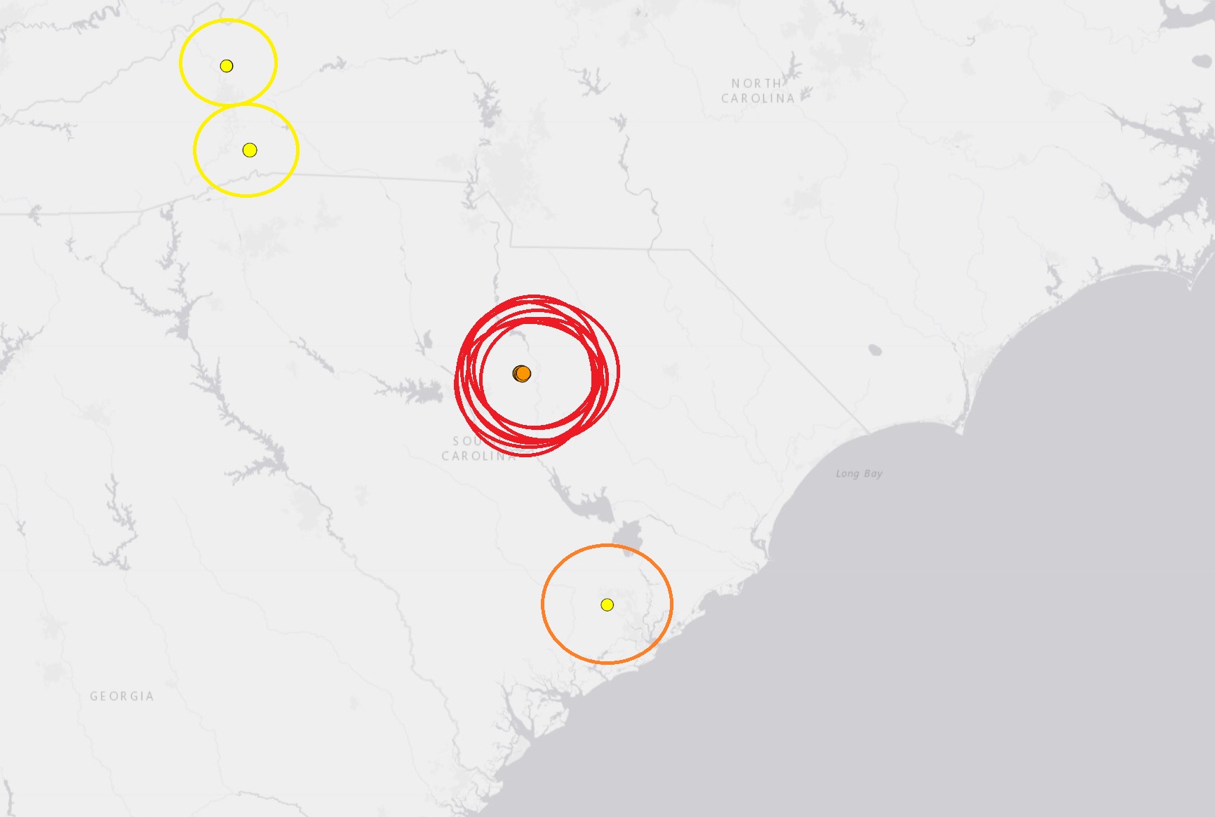
Today, three earthquakes were reported by USGS, all in the Elgin / Lugoff area of South Carolina which is located north and east of Columbia. The first, a magnitude 2.3 event, struck at a depth of 3.1 km at 12:23 am shortly after midnight; it was located 6 km east of Elgin. The second, a magnitude 2.0 event, struck at a depth of 3.1 km at 5:22 am; the epicenter was 7 km east-southeast of Elgin. . The third struck 7 km south-southwest of Lugoff at a depth of 2.6 km at 10:15 am; it was rated by USGS as a 2.2 magnitude event.
While leaving residents rattled, today’s earthquakes aren’t as strong as yesterday’s, which generated thousands of responses to USGS’s “Did you feel it?” online earthquake survey.
The first earthquake, with an epicenter 5 km east of Elgin, South Carolina, struck this afternoon at 2:43 pm. It had a depth of 2.6 km. USGS said this quake was a magnitude 3.5 event.
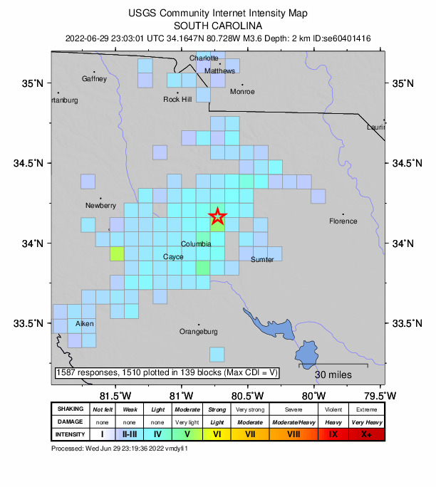
The second earthquake, which struck at 7:03 pm, was the strongest yet. That quake, ranked as a magnitude 3.6 event, was 3.0 km deep and had an epicenter not far from the earlier quake, roughly 6 km east of Elgin.
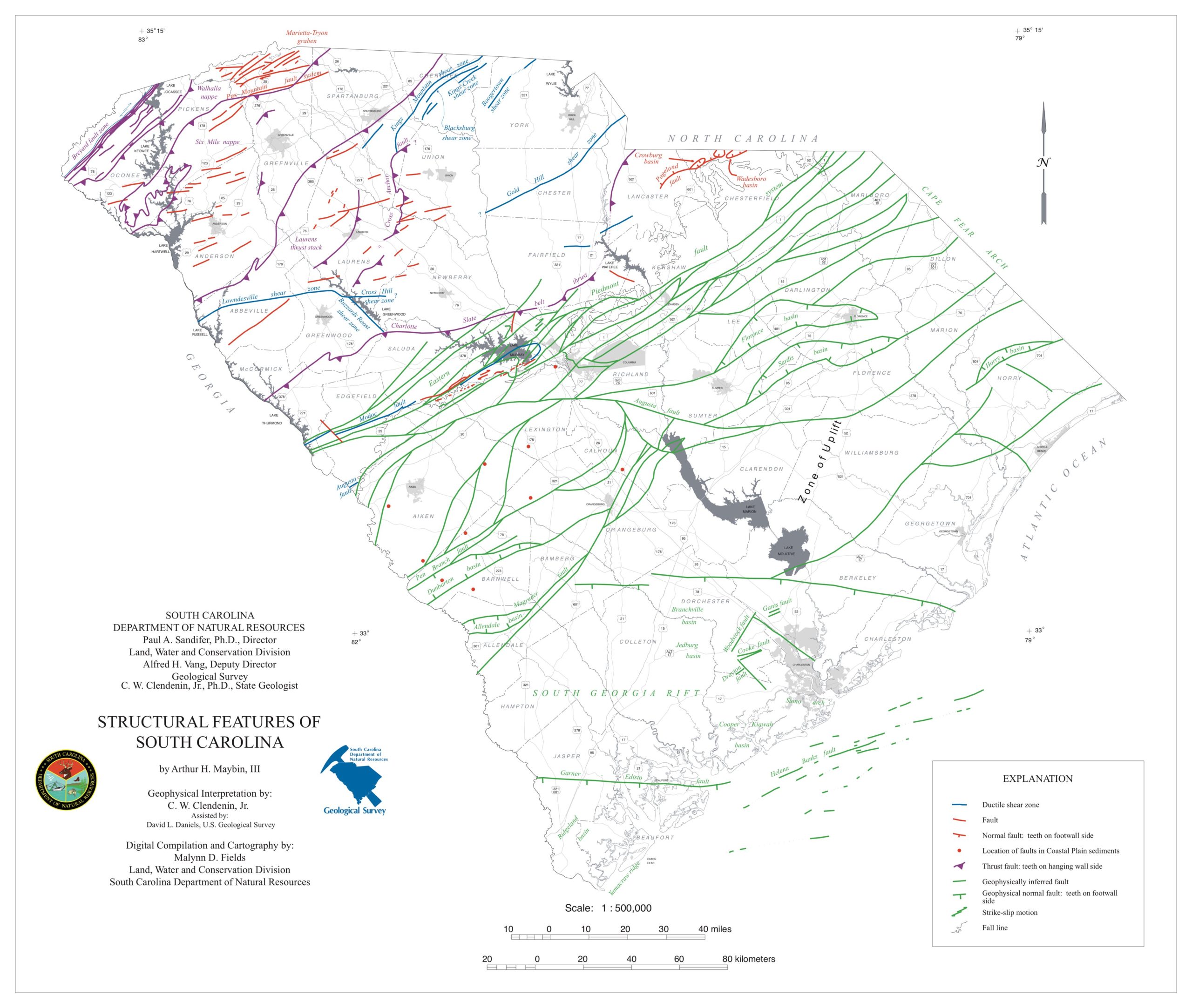
Several more earthquakes shook South Carolina this weekend, puzzling many that aren’t completely sure why the mysterious rattle continues. Dozens of earthquakes within this swarm have struck South Carolina over the last 7 months. The earthquakes this weekend have all been around Elgin, a small incorporated town in Kershaw, roughly 20 miles northeast of Columbia, the state’s capital. Elgin lies within the Carolina Sandhills region of the Atlantic Coastal Plain province; this region is characterized by many dunes of wind-blown sand that were active during the last ice age but the dunes are currently stabilized by vegetation under modern climate conditions.
The strongest of the five that hit this weekend was a 3.4 magnitude event that occured late last night at a depth of 3.3 km. All five earthquakes hit at about the same location, although at slightly different depths. There as a 1.5 event at 5 km, a 1.3 event at 2.1 km, a 1.8 event at 3.2 km, and another 1.8 event 3.3 km deep after the magnitude 3.4 earthquake. None were strong enough to create damage although more than 3,500 residents reported they felt shaking from the 3.4 event to the USGS.
A few dozen earthquakes have struck seismically active South Carolina since December. These weak to moderate earthquakes struck after a swarm came and went in December. The mysterious swarm began on Monday, December 27, at 2:18 pm in the afternoon. That first 3.3 magnitude earthquake hit 30 miles north of Columbia, South Carolina at a depth of only 3.1 km. More than 3,100 residents reported to USGS they felt it at the time, with one report of shaking coming from as far away as Rock Hill, which is at the North/South Carolina state border. While many felt the earthquake, there was no reported damage in the Palmetto State. That earthquake was followed by 10 more ranging in intensity between a magnitude 1.5 to a magnitude 2.6 event. The second earthquake struck three hours twenty minutes after the first one. The last earthquake in that series struck on the morning of January 5, bringing a temporary end to the earthquakes there.
According to USGS, a swarm is a sequence of mostly small earthquakes with no identifiable mainshock. “Swarms are usually short-lived, but they can continue for days, weeks, or sometimes even months,” USGS adds. However, the South Carolina event doesn’t fit the typical definition of a swarm since the first event was substantially larger than the rest.
According to USGS, “aftershocks” are a sequence of earthquakes that happen after a larger mainshock on a fault. “Aftershocks occur near the fault zone where the mainshock rupture occurred and are part of the ‘readjustment process’ after the main slip on the fault,” says USGS. However, aftershocks of a 3.3 magnitude earthquake would only last a few days, not the week plus they have.
According to the South Carolina Emergency Management Division (SCEMD), there are approximately 10-15 earthquakes every year in South Carolina, with most not felt by residents; on average, only 3-5 are felt each year. Most of South Carolina’s earthquakes are located in the Middleton Place-Summerville Seismic Zone. The two most significant historical earthquakes to occur in South Carolina were the 1886 Charleston-Summerville earthquake and the 1913 Union County earthquake. The 1886 earthquake in Charleston was the most damaging earthquake to ever occur in the eastern United States; it was also the most destructive earthquake in the U.S. during the 19th century.
There is some concern that mining in South Carolina could be playing a role with these earthquakes. However, the South Carolina Department of Health and Environmental Protection Agency disputes that idea. In a series of Tweets today, they wrote, “Currently, DHEC-permitted mine sites in the area are surface pits, and the majority are 30 ft. or less in depth. Their shallowness would not be expected to contribute to seismic activity, especially with recent earthquakes being recorded at 6,336 to 12,672 feet deep…Even the deepest permitted mine site, at 900 feet, doesn’t come close to this depth, and it is 75 miles away from Elgin.”
Some believe fracking could be at play, but there are no fracking sites in this region.
No one is sure what’ll become of this steady stream of light earthquakes or whether or not something larger is looming. For now, the SCEMD has been sending out Tweets to the people of South Carolina encouraging them to be prepared for any disaster this year –earthquakes included.
Do you know what to do if an #earthquake hits while you’re in 🛌 ? Have a 🔦 & 👞 👞 next to your 🛏 .Stay in 🛌 , don’t risk injury on potential hazards. Turn onto your stomach. Cover your head & neck with a pillow. Wait until the shaking stops. Put on 👞 before leaving 🛏 . pic.twitter.com/m5QeE12IEK
— SCEMD (@SCEMD) January 6, 2022
