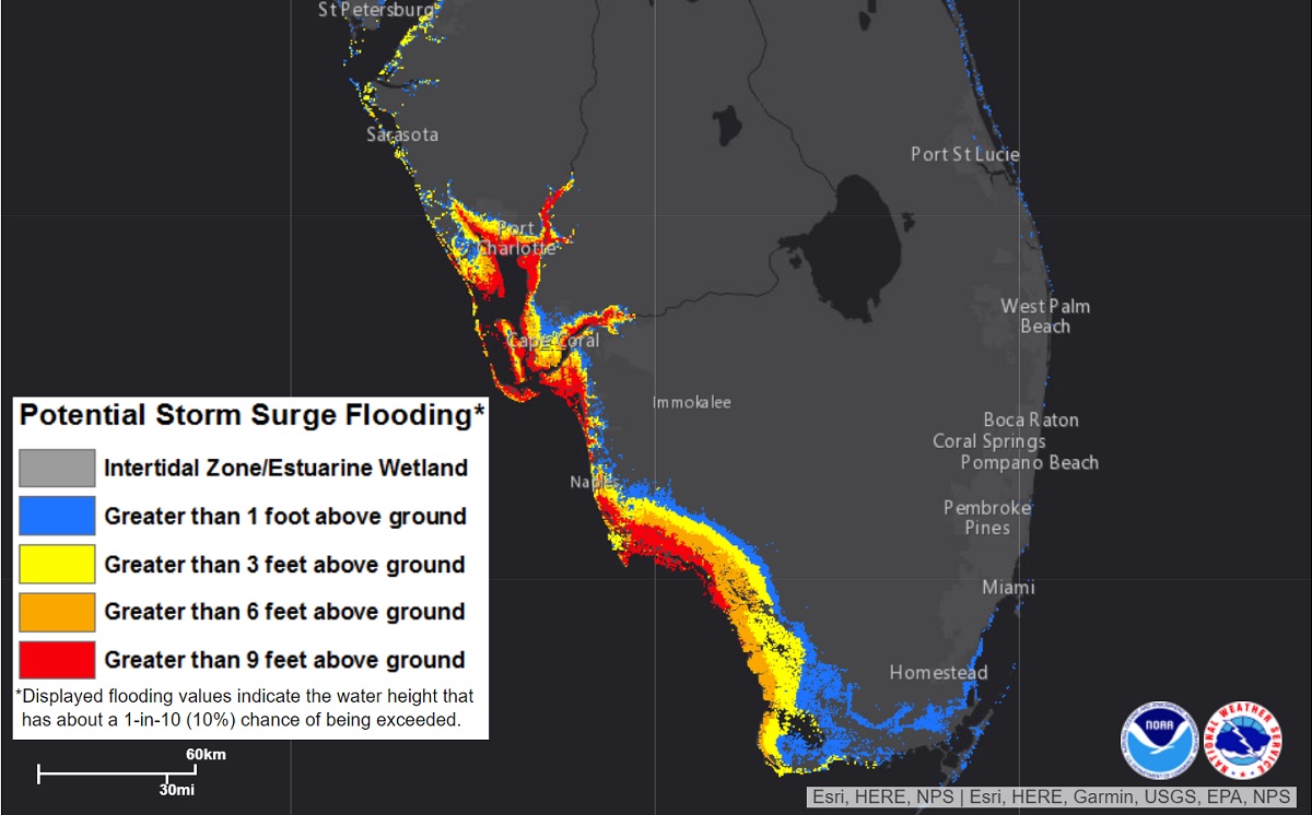
Major Hurricane Ian, now with maximum sustained winds of 120 mph and getting stronger yet, is likely to create an epic, catastrophic storm surge for portions of the Florida Gulf Coast. At the moment, it appears the communities of Fort Meyers, Cape Coral, Sanibel and Captiva Islands, Boca Grande, and Port Charlotte will bear the brunt of the hurricane’s storm surge. The National Hurricane Center is warning the storm surge could exceed 8-12′ in this area, with even areas far from the shoreline could be submerged by more than 6′ of water.
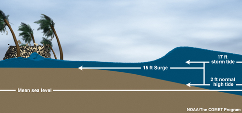
Storm surge is an abnormal rise of water generated by a storm, over and above the predicted astronomical tides. Storm surge should not be confused with storm tide, which is defined as the water level rise due to the combination of storm surge and the astronomical tide. This rise in water level can cause extreme flooding in coastal areas particularly when storm surge coincides with normal high tide, resulting in storm tides reaching up to 20 feet or more in some cases.
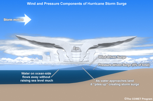
Storm surge is produced by water being pushed toward the shore by the force of the winds moving cyclonically around the storm. The impact on surge of the low pressure associated with intense storms is minimal in comparison to the water being forced toward the shore by the wind.
Right now, a Storm Surge Warning is in effect for the area between the Suwanee River southward to Flamingo, all of Tampa Bay, the Dry Tortugas, Marineland to the mouth of the St. Mary’s River, and the St. Johns River. A Storm Surge Watch is in effect for the Florida Keys from the Card Sound Bridge westward to Key West, Florida Bay. the area from the Aucilla River to Suwanee River, the area around the mouth of St. Mary’s River to South Santee River, and the region south of Marineland to the Volusia/Flagler county line. A Storm Surge Warning means there is a danger of life-threatening inundation, from rising water moving inland from the coastline, in the indicated locations. The National Hurricane Center warns, “This is a life-threatening situation. Persons located within these areas should take all necessary actions to protect life and property from rising water and the potential for other dangerous conditions.” A Storm Surge Watch means there is a possibility of life-threatening inundation, from rising water moving inland from the coastline, in the indicated locations during the next 48 hours.
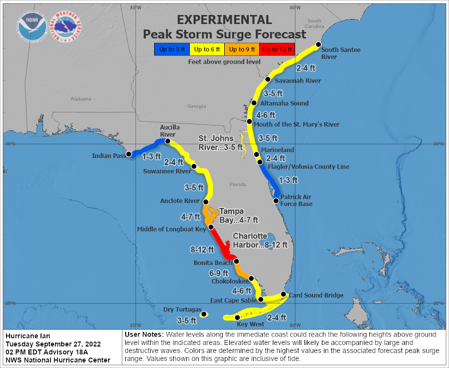
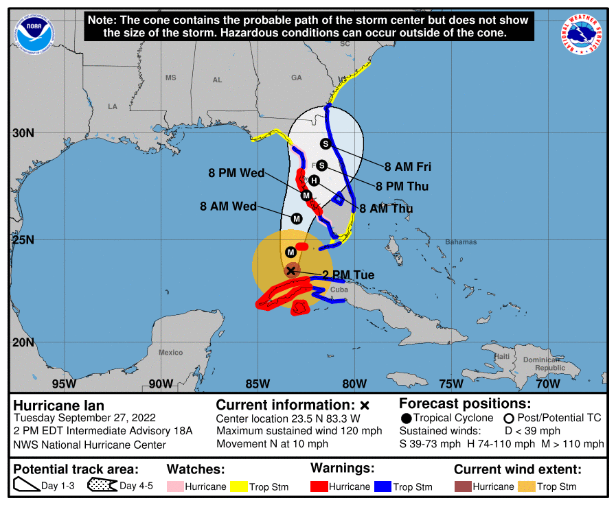
According to the latest advisory from the National Hurricane Center (NHC), Major Hurricane Ian is located about 265 miles south of Sarasota Florida and about 85 miles south-southwest of the Dry Tortugas. Maximum sustained winds are up to 120 mph and additional strengthening is forecast. The storm is moving to the north at 10 mph. This forward motion is expected to slow somewhat prior to landfall as the direction of the storm ever so slowly develops a slightly eastward component over time to bring the storm to the central Florida Gulf Coast.
Beyond life-threatening storm surge, destructive winds, extremely heavy rains of 1-2’+, and widely scattered tornadoes are likely throughout much of the Florida Peninsula. People away from the coast should prepare to shelter in place in sturdy buildings.
