
Major Hurricane Kiko continues to spin about over the open waters of the Central Pacific Ocean. But fortunately for the Aloha State, it is unlikely Hawaii will see a direct impact from the hurricane with the official National Hurricane Center forecast and other forecast guidance taking the storm well north of Hawaii. However, with a weakening hurricane passing north of Hawaii, the weather pattern will be influenced by Kiko’s close passage, setting the stage for interesting weather for a few days.
According to the Central Pacific Hurricane Center in Honolulu, Hawaii, satellite imagery indicates that Kiko has continued to strengthen over the last few hours and is once again a category 4 hurricane on the Saffir-Simpson Hurricane Wind Scale. The satellite-based estimated maximum sustained winds are now near 130 mph with higher gusts.
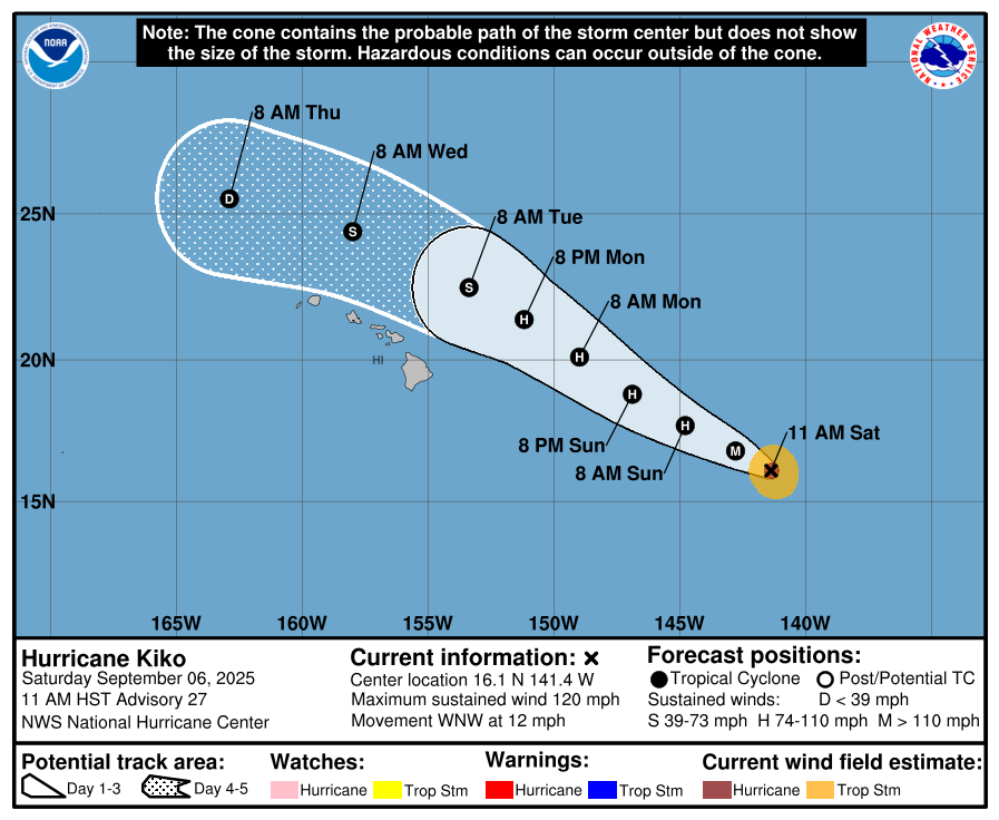
The storm is about 895 miles east-southeast of Hilo on the Big Island of Hawaii and about 1,100 miles east-southeast of Honolulu on the island of Oahu.
Major Hurricane Kiko is moving west-northwest at 12 mph and has a minimum central pressure of 947 mb or 27.96″.
With Kiko moving toward the west-northwest near 12 mph now, the Central Pacific Hurricane Center expects that this general motion will continue for the next few days.
The hurricane is on the south side of a low- to mid-level ridge, and a mid- to upper-level low seen in satellite imagery near and north of Hawaii is eroding the ridge’s western end. This pattern should cause Kiko to move west-northwestward to perhaps northwestward for the next 72 hours or so, according to the Central Pacific Hurricane Center. After that time, a more westward track is expected as Kiko shears apart vertically and the weakening cyclone is steered more by the low-level easterly flow.
During the next 2 days or so, Kiko should be passing over sea surface temperatures near 26C while it moves through a dry mid-level air mass. This combination should cause some weakening. After that, while the sea surface temperatures get warmer along the forecast track, strong vertical shear produced by the upper-level low should cause continued weakening, with Kiko expected to shear apart vertically by 72-96 hours from now.
Kiko is forecast to approach the Hawaiian Islands during the early to middle portion of next week.
“Confidence is increasing that Tropical Cyclone Kiko will pass far enough north of the state next week to decreases the likelihood of any direct impacts to Hawaii,” the National Weather Service office in Honolulu, Hawaii said a short time ago. “However, life-threatening surf along east-facing shores will be possible along with an increased potential for statewide rainfall.”
The Central Pacific Hurricane Center is also cautious with the forecast. In their last update, they said, “While the forecast track currently calls for Kiko to pass north of the islands, it is still too soon to determine the exact location or magnitude of potential impacts from the cyclone’s winds or rains. Interests in the Hawaiian Islands should continue to monitor the progress of this storm.”
While the wind and rain associated with the storm should remain well off-shore, Kiko will help foster an environment that sweeps rainfall-rich, moist air across much of the islands; it will also help drive surf and swells to Hawaii. Because of this influence the near-miss of the hurricane on Hawaii will have on the state’s weather, some life threatening conditions are possible even without a direct hit.
Swells generated by Kiko are expected to begin reaching the Big Island and Maui by Sunday. These swells will gradually build and are forecast to peak along east-facing exposures of the Hawaiian Islands late Monday through midweek, potentially producing life-threatening surf and rip currents. “Listen for later advisories and possible warnings from the National Weather Service,” the Central Pacific Hurricane Center said.
Moisture may also wrap around the storm ; the hurricane may also help bring very moist air from near the equator north over the islands as it passes to the north on westerly and southerly flows that are atypical of the east-to-west trade winds Hawaii sees. This could create situations where there may be isolated heavy rain in areas that are normally dry while some areas that are especially wet may stay dry with the trades disrupted as Kiko moves away to the north and west.
