
A Mass Casualty Emergency Event was declared today at Daniel K. Inouye International Airport at Honolulu on the Hawaiian Island of Oahu; Hawaiian Airlines flight 35 which originated in Phoenix, Arizona encountered extreme turbulence as it began its decent into the Hawaiian airspace. Officials with Honolulu Emergency Medical Services and American Medical Response say the flight encountered the extreme turbulence about 30 minutes prior to landing; they treated 36 patients at the airport. 20 patients, ranging from a 14-month old toddler to older adults, were transported to hospitals near the airport. 11 are in serious condition while 9 are in stable condition, with patients spread out in multiple emergency rooms.
According to a statement released by Hawaiian Airlines, “Flight 35 from Phoenix to Honolulu today encountered severe turbulence shortly before arrival. The Airbus A330 aircraft carrying 278 passengers and 10 crewmembers landed safely in Honolulu about 10:50 am.” The airline added, “The airline is supporting all affected passengers and employees and will provide additional information as it becomes available.”
On Twitter, Hawaiian Airlines Tweeted “Medical care was provided to several guests and crewmembers at the airport for minor injuries while some were swiftly transported to local hospitals for further care.”
Weatherboy reached out to Hawaiian Airlines for additional details but heard nothing back as of publication time.
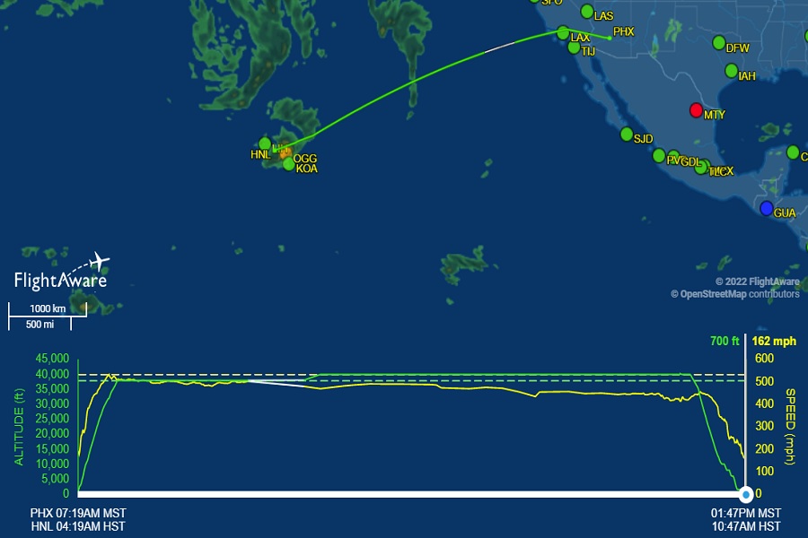
Flight tracking website FlightAware shows the flight having a routine journey across the Pacific until it encountered strong thunderstorms near the State of Hawaii. The flight left Phoenix just one minute late and had no unusual flight behavior until about 30 minutes prior to landing. At that point, FlightAware shows a deviation in both altitude and speed as it uncounted a thunderstorm north of the islands of Maui and Hawaii before making a final approach into Oahu’s Honolulu airport. The flight left Phoenix at 7:19 am MST / 4:19am HST and landed at 1:47 pm MST / 10:47am HST.
Photos shared on social media show where heads and bodies were thrown up and into service panels and overhead luggage storage spaces, cutting up the plastic inside the cabin. According to Emergency Medical Services, injuries to people on the flight included serious head injury, lacerations, bruising, and loss of consciousness.
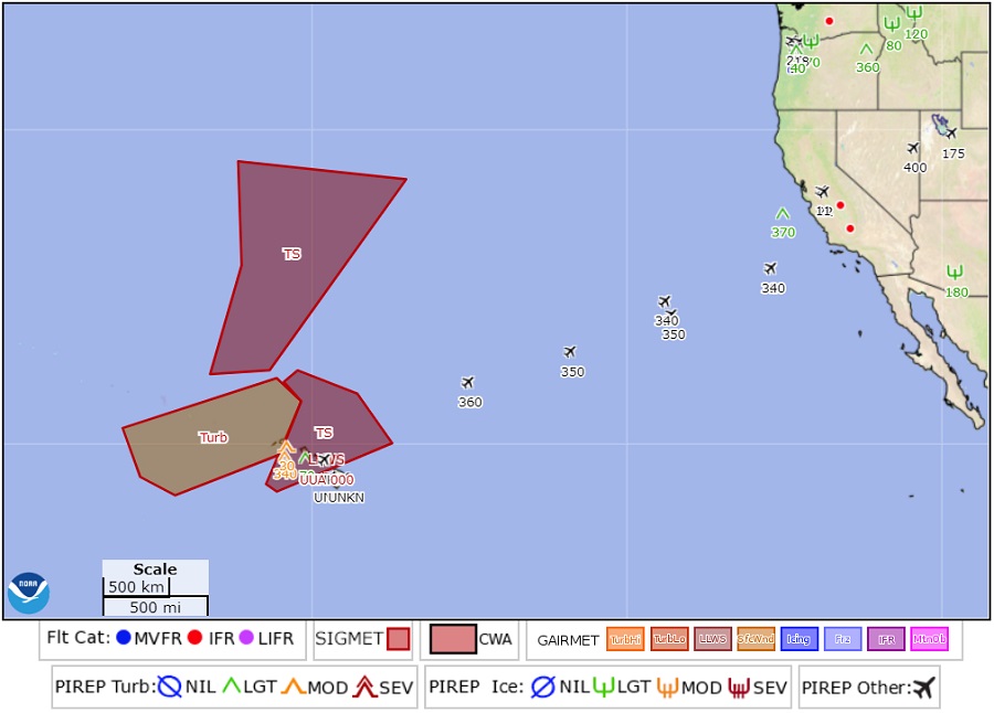
According to the National Weather Service’s Aviation Weather Center (AWC), the area the Hawaiian Airlines flight flew into was flagged for hazardous flight conditions. Known as a SIGMET, short for Significant Meteorological Information, the severe weather advisory issued by the AWC contains weather-related information concerning the safety of all aircraft passing through a specific zone. In this case, a SIGMET covered the final path of the Hawaiian Airlines flight today, alerting the presence of thunderstorms in the area. A SIGMET for turbulence was also posted west of the area from Kauai Island west.
In an Aviation Weather Forecast Discussion, meteorologists wrote, “Model data suggests that moderate to severe clear-air turbulence will be possible behind the main area of showers this afternoon into early evening. Should this materialize, an AIRMET for moderate upper level turbulence or possibly a SIGMET for severe turbulence from roughly Kauai to Oahu would be needed.”
An AIRMET consists of turbulence, visibility, and icing-related warnings that are less severe than those in a SIGMET.
A powerful winter storm is blasting the Hawaiian Islands today into tomorrow with everything from severe thunderstorms to blizzard conditions. Heavy snow up to 14″ and destructive wind gusts up to 135 mph, which are the equivalent of Category 3 hurricane windspeeds, are possible for Hawaii’s highest terrain. Elsewhere in the islands, including resort areas on the beaches, severe thunderstorms with damaging wind gusts and large hail are possible. At the coast, 20-40 foot waves are possible on some north facing beaches in the islands. The storm has prompted the National Weather Service to issue a variety of warnings across Hawaii including Winter Storm Warning, Flash Flood Warning, High Surf Warning, High Wind Warning, Special Marine Warning, and Gale Warning.
