After an impressive snow drought in the northeast, caused in part by an onslaught of Atmospheric River events in California, the weather pattern is changing and computer forecast models are picking up on changes and suggesting the chance for a nor’easter or multiple nor’easters which could bring snow to areas that haven’t seen much at all in about 1-2 weeks.
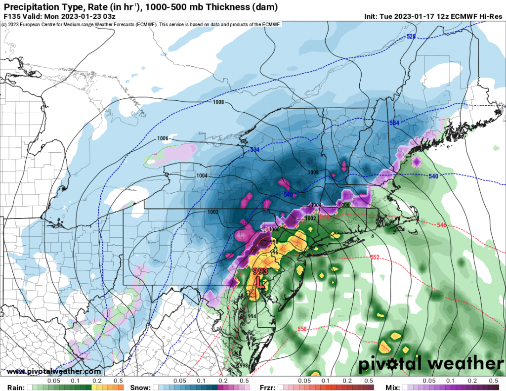
While extended guidance has suggested all along that a pattern change would result in very different weather in the eastern U.S. come February, computer forecast models like the American GFS and European ECMWF suggest a change may arrive as soon as on/around January 23 resulting in snow to the East.

The GFS and ECMWF are among many computer models meteorologists use to assist in weather forecasting. While meteorologists have many tools at their disposal to create weather forecasts, two primary global forecast models they do use are the ECMWF from Europe and the GFS from the United States. While the models share a lot of the same initial data, they differ with how they digest that data and compute possible outcomes. One is better than the other in some scenarios, while the opposite is true in others. No model is “right” all the time. Beyond the ECMWF and GFS models, there are numerous other models from other countries, other academic institutions, and private industry that are also considered when making a forecast.
For the second half of December and most of January, both major global forecast models have been adamant about keeping traditional winter weather out of the Eastern U.S.. With storm after storm hitting California, the jet stream has moved across the country in mainly a zonal fashion, quickly bringing storms from west to east without much chance for amplification or coastal regeneration. Extended guidance has suggested that pattern would change in February, but not global guidance is suggesting that may happen as soon as a week or two from now.
This afternoon’s ECMWF has a strong nor’easter signal on it for around January 23, with heavy inland snow and wind-whipped heavy rains depicted on surface charts of the northeast. It’s possible with time, the rain/snow line depicted by this model may shift significantly south and east or north and west.
Today’s GFS also depicts a storm signal for around January 23 and another one on January 26 and a third one on January 31.
These runs are a clear departure from other runs in other recent days, that kept the idea of east coast storms off the table until February.
However, future runs may just as quickly take these potential storms off the table too. Because the weather pattern is evolving, computer models may be too eager to project storm systems that may not ever form.
While the weather pattern adjusts and computer forecast models get a better handle on the changes, the snow drought will continue.
While parts of southeastern New England were brushed by light snows just days ago, some other cities like Philadelphia, New York City, and Washington DC have seen little to no snow. In Philadelphia, the National Weather Service is reporting 0.00″ of snow to date there –the first time there’s never been snow in January on record since 1874 in the City of Brotherly Love. While Philadelphia did have two events that each brought a trace of snow to the city in December, the winter thus far has been relatively snowless.
The same has been true for other cities in the Mid Atlantic and Northeast; it remains to be seen if computer models are onto something and that a big change to the weather pattern is coming soon.