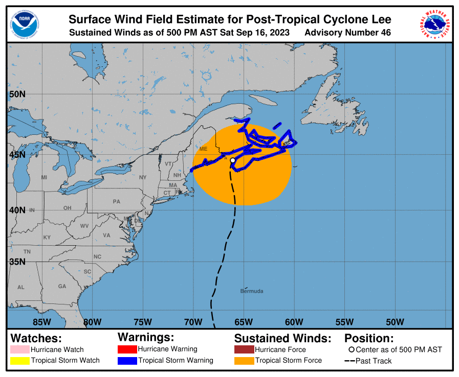
The core of Post Tropical Cyclone Lee is pushing through Nova Scotia now, bringing strong winds, coastal flooding, and heavy rains not only to Atlantic Canada, but large parts of Maine too. The storm, once a hurricane, is taking on more and more traditional low pressure characteristics, but is still packing quite a bunch.
As of the latest update from the National Hurricane Center (NHC), Lee is about 50 miles east-southeast of Eastport, Maine and about 125 miles west of Halifax, Nova Scotia. Maximum sustained winds are 70 mph while the minimum central pressure is at 970 mb or 28.65″. The storm is moving north at 16 mph.
With the storm forecast to further weaken, Environment Canada, the Canadian equivalent of the U.S. National Weather Service, has discontinued the Hurricane Watch for New Brunswick and Nova Scotia. In the U.S., the NHC has discontinued the Tropical Storm Warning that was in effect south of Cape Elizabeth, Maine.
However, warnings do remain elsewhere. A Tropical Storm Warning is in effect for Cape Elizabeth northward to the U.S./Canada border, New Brunswick from the U.S./Canada border to Belledune, including Grand Manan Island, all of Nova Scotia, Prince Edward Island, and the Magdalen Islands. A Tropical Storm Warning means that tropical storm conditions are expected somewhere within the warning, in this case today through Sunday.
The post-tropical cyclone is moving toward the north near 16 mph now and a faster northeastward motion is expected during the next day or so according to the NHC. On this path, the system will track across the Canadian Maritimes. Steady weakening is forecast during the next couple of days but the storm will remain a large, wide one: tropical-storm-force winds extend outward up to 320 miles from the center.
Tropical storm conditions are occurring along the coasts of Maine and Nova Scotia and will spread northward within the Tropical Storm Warning areas through tonight. The strong winds are leading to downed trees and power outages.
Swells generated by Lee continue to affect Puerto Rico, Hispaniola, the Turks and Caicos Islands, the Bahamas, Bermuda, the east coast of the United States, and Atlantic Canada. These swells are likely to cause life-threatening surf and rip current conditions.
Lee may produce an additional 1-2″of rain over portions of eastern Maine and New Brunswick. This may produce localized urban and small stream flooding.
A dangerous storm surge will produce coastal flooding within the wind warning areas in Atlantic Canada in areas of onshore winds. Near the coast, the surge will be accompanied by large and destructive waves.