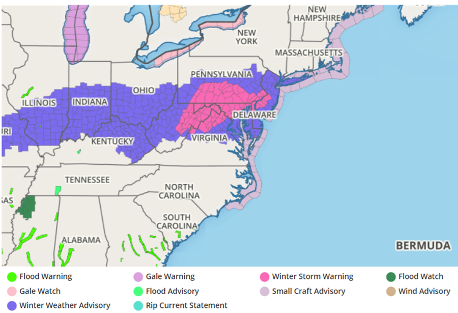
Winter Storm Warnings have been issued for portions of New Jersey, Pennsylvania, Delaware, Maryland and Virginia for a snow event expected to unfold tonight into tomorrow morning; however, people in this region should be aware that the National Weather Service changed the criteria for these warnings for this season.
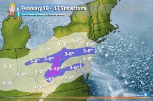
A fast-moving system will bring a widespread 2-4″ snowfall through portions of the Mid Atlantic, with some 3-6″ amounts possible too. The highest terrain of central Pennsylvania, western Maryland, and eastern West Virginia could see in the 6-12″ range, although those amounts will fall in mainly unpopulated mountainous areas.
Due to a change in criteria for Winter Storms that the National Weather Service made last fall, some of the forecast snowfall amounts are now warnable whereas in the past they weren’t.
Normally, a Winter Storm Watch will be issued in advance of an arriving winter storm, usually at least 24 hours in advance. When this is issued by a local National Weather Service office, it indicates the risk of a hazardous winter weather event has increased, with at least a 50% chance of it occurring, but its occurrence, location, and/or timing is still uncertain. It is intended to provide enough lead time so you can make plans to stay safe.
As the event becomes imminent, a watch will normally be upgraded to either a warning or an advisory (which indicates an 80% or greater probability of occurrence). A Warning indicates that conditions pose a threat to life or property, and that travel will become difficult to impossible. An Advisory indicates conditions pose a significant inconvenience, and if caution is not exercised, could lead to situations that may threaten life and/or property.
Usually, heavy snow is the determining factor for a Winter Storm Warning; the heavier the snow, the more likely a warning is to be issued. However, the National Weather Service has evaluated societal impacts of snowfall. In places where it snows frequently and there are active snow removal experts, 5″ of snow may not be that big of an issue; however, in places where it rarely snows and there’s little to no snow or ice removal equipment available, 5″ could be a crippling event.
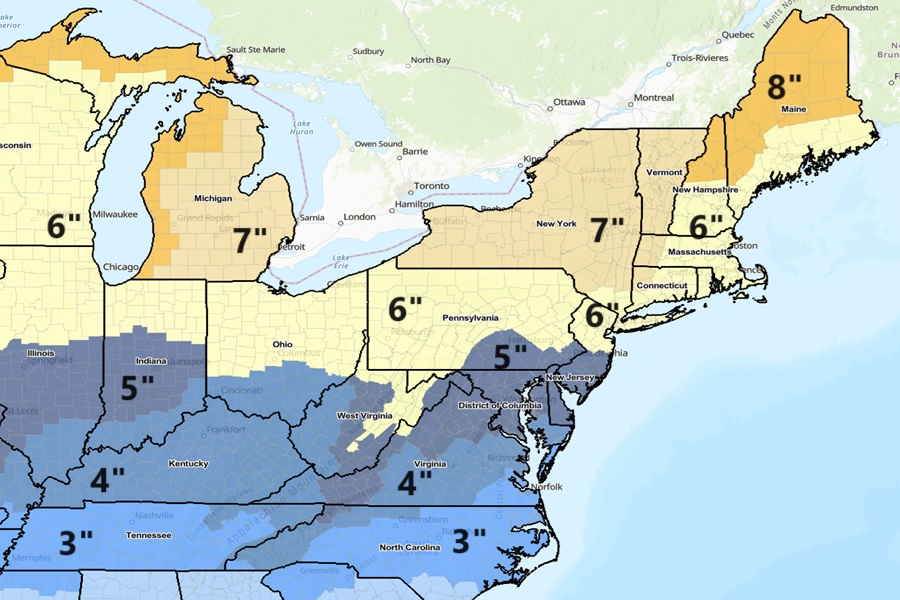
With the societal impacts factored in, the National Weather Service has revised the criteria across the country for what is considered to be a “heavy snow” event.
Across northern New Hampshire and Maine, heavy snow is 8″. In New York City and Boston and surrounding areas, it is 6″. For Philadelphia, it is now 5″. For eastern Virginia, it is now 3″.
While Winter Storm Watches and Warnings are indicative of an approaching winter storm, there are other advisories the National Weather Service can issue too. An Ice Storm Warning can be issued if a significant accumulation of ice is impacting an area. A Blizzard Warning can be issued when blizzard conditions (low visibility of less than 1/4 mile due to falling and/or blowing snow, and winds at least 35 mph) are expected for at least 3 hours
