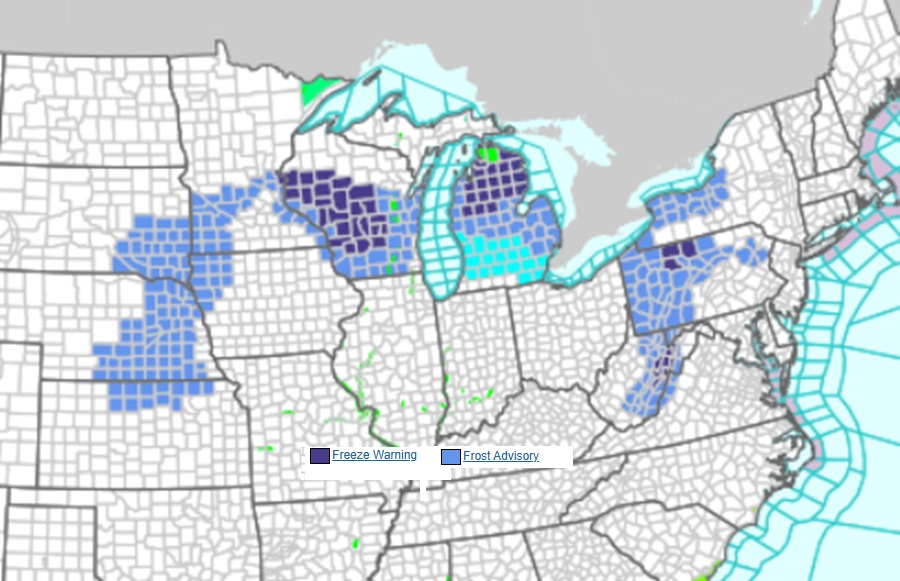
Unseasonably cold temperatures have prompted the National Weather Service to issue Frost and Freeze related advisories for a large part of the eastern United States. Frost Advisories are up for portions of Nebraska, South Dakota, Kansas, Iowa, Minnesota, Michigan, Wisconsin, Pennsylvania, New York, West Virginia, Maryland, and Virginia. Freeze Warnings are in effect for portions of Michigan, Wisconsin, Pennsylvania, and West Virginia.
Cooler, below average temperatures have settled in across most of the eastern and central U.S. following a cold front passage and will linger into the weekend. Forecast highs the next couple of days generally range in the 40s and 50s from the northern Plains east through the Great Lakes and into New England; the 50s and 60s for the central/southern Plains east through the Mississippi/Ohio Valleys and into the Mid-Atlantic; and the 60s with some low 70s through the Southeast. Morning lows dropping into the lower 30s Friday have prompted some Frost/Freeze related advisories for portions of the Midwest/Great Lakes into the Appalachians.
A Frost Advisory is issued by the National Weather Service (NWS) during the growing season when temperatures are expected to drop to 33°F–36°F on clear, calm nights. These conditions can cause frost to form, which may harm or kill sensitive, unprotected outdoor plants.
A more serious Freeze Warning is issued by the NWS when temperatures are forecast to drop to 32°F or colder over a widespread area for an extended period, signaling the end of the growing season. It indicates that significant, damaging, and sometimes “killing” cold is expected, necessitating protection for plants and pipes. Gardens and crops that were planted earlier could be damaged or killed due to the expected cold in the Freeze Warning areas.
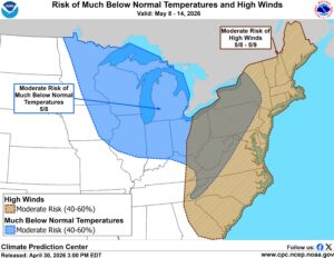
Additionally, high winds could create wind chill readings very low by May standards all the way to the east coast. Very cold wind chill readings could be found along the coast from the Carolinas north to Maine.
