As the first weekend of November begins, some heavy rain and severe thunderstorms more typical of late spring than mid fall will make its presence known over portions of the East Coast. A cold front will slowly cross the East Coast later tonight and early Saturday as low pressure tracks along it. This set-up will create a broad area of soaking rains with the potential for gusty severe storms too. High pressure will build in Saturday night and Sunday before shifting to near the Canadian Maritimes by Monday morning. This high will allow for dry conditions to return to the wet East for the balance of the weekend.
For now, a strong surface low is near the eastern Great Lakes with a warm front extending eastward into southern New England and a cold front extending southwestward into the eastern Ohio/Tennessee Valleys. Meanwhile, a southern-stream weather system was rounding the base of the central U.S. large-scale trough and will head northeastward today, reaching the central Appalachians late this afternoon. The strongest of three systems will dig into the Tennessee Valley late tonight, allowing the large-scale trough to acquire a negative tilt. Rapid cyclogenesis will occur at the nose of this system in the central Mid Atlantic before moving northeastward late tonight.
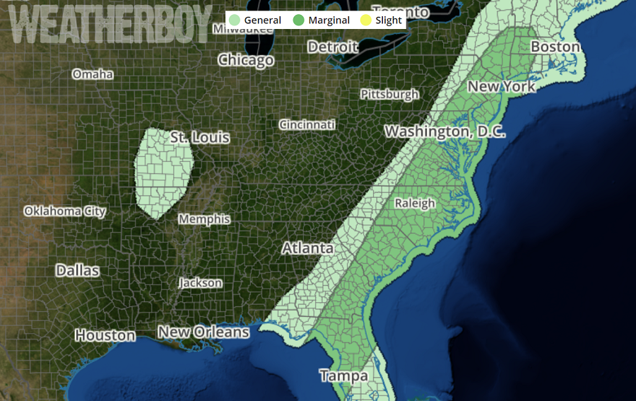
Instability will be increasing today across the East Coast, with chances of thunder gradually increasing with any showers that develop. The latest high resolution, short-term computerized forecast guidance suggests the potential for strong convective cores with any precipitation that develops this morning. With strong winds aloft, the most intense convective cores are capable of producing an isolated strong to even damaging wind gusts. Conditions could be just right to create an isolated tornado or two too, with the greatest threat between a wide area that extends from Albany, NY and Jacksonville, FL, including the cities of New York, Philadelphia, Baltimore, Washington DC, Raleigh, and Charleston. However, the chances of severe thunderstorms and tornadoes are low and while isolated strong to severe cells will develop, not everyone will see one.
After a morning disturbance moves off-shore later this morning, there should be a lull in precipitation in the Mid Atlantic from late morning to early afternoon. The second disturbance will move in during the early afternoon hours, bringing rain and thundershowers to the region then. It is these showers and storms that could produce heavy rain over a short period of time.
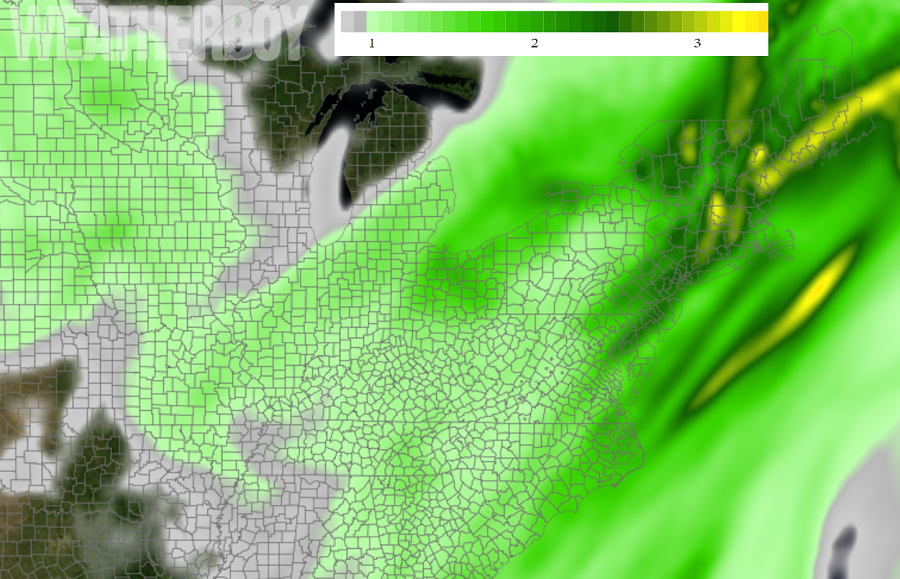
The heaviest rain will fall at or after dinner time, with the heaviest amounts expected along the I-95 corridor from Washington, DC to Boston, MA; some amounts in southern New England could exceed 3″ by tomorrow morning, which could create isolated flooding concerns. The National Weather Service cautions: “turn around, don’t drown; never drive through flood waters.”
The cold front will swing through the coast during the overnight period, with widespread rain and embedded storms near/in advance of the front and more showery precipitation in wraparound precipitation on the back side of the front. The main precipitation shield should begin to move off-shore after midnight, but wraparound showers are likely to linger into the early morning hours tomorrow. As showers wrap up Saturday morning, dry air will return on gusty northwest winds as the high pressure system returns to the region.
