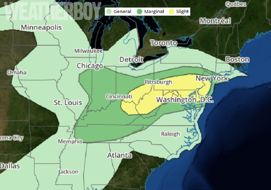
For the third day in a row, meteorological ingredients will come together to create conditions ripe for severe thunderstorms and isolated tornadoes in the Mid Atlantic. According to the National Weather Service’s Storm Prediction Center (SPC), severe thunderstorms capable of damaging wind gusts, hail and a couple of tornadoes are possible from a portion of the Ohio Valley to the Middle Atlantic today. Severe thunderstorms are also possible from eastern New Mexico and the southern High Plains into central and southwest Texas. But when it comes to the possibility of tornado formation, the best conditions anywhere in the nation will be over southeastern Pennsylvania, southern New Jersey, northern Delaware, and northeastern Maryland.
An upper low initially centered over Iowa, and associated troughing, is forecast to advance east-southeast across the mid Mississippi Valley through the day, and into the Midwest/Ohio Valley with time, while a weaker, more diffuse lead disturbance shifts across the Midwest and into the Northeast. Farther west, an upper low is forecast to drift southward across northern California. A weaker perturbation within the broader cyclonic flow around this low is forecast to cross northern Mexico and the Desert Southwest , reaching eastern New Mexico and western Texas by evening. At the surface, a weak front will linger from the mid Atlantic region westward across the Ohio Valley region, with a frontal wave forecast to advance roughly along the Mason/Dixon line through the day, and then off the mid Atlantic Coast by evening. As a result of this, an area of severe weather is likely to blossom later in the afternoon across portions of the Mid Atlantic and in southwest Texas.
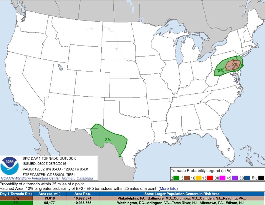
According to the SPC Tornado Outlook, some of these storms could create isolated tornadoes. Due to this threat, the National Weather Service may issue Severe Thunderstorm and/or Tornado Watches during the day. Inside or near these watches, Tornado Warnings may be issued too. A Tornado Warning is issued when weather RADAR indicates a tornado and/or a trained spotter has observed a tornado. Tornado Warnings are typically issued on a by-county basis, and last generally 30 minutes, give or take 15 minutes depending on the speed of the storm and the size of the county impacted. When a Tornado Warning is issued:
- Go to the basement or take shelter in a small interior ground floor room such as a bathroom, closet or hallway.
- If you have no basement, protect yourself by taking shelter under a heavy table or desk.
- In all cases, stay away from windows, outside walls and doors.
This should be the last tornadic and/or severe weather threat in the Mid Atlantic for this week. A frontal system will push the responsible disturbance out of the region tonight, bringing fair and dry high pressure into the area in time for Friday.
