Rain and snow showers falling in the northeast today will diminish as a cold area of high pressure builds into the northeastern United States; while cold air is coming, snow isn’t. Computer forecast guidance continues to paint a bleak outlook for the I-95 corridor in the eastern U.S. for snow lovers: there does not appear to be any significant snowstorm threat on the horizon through to the end of the month. While February is typically known as one of the snowiest months of the year, the winter of 2019-2020 may not have much in the way of any snow for cities like Boston, New York, Philadelphia, Baltimore, and Washington, DC.
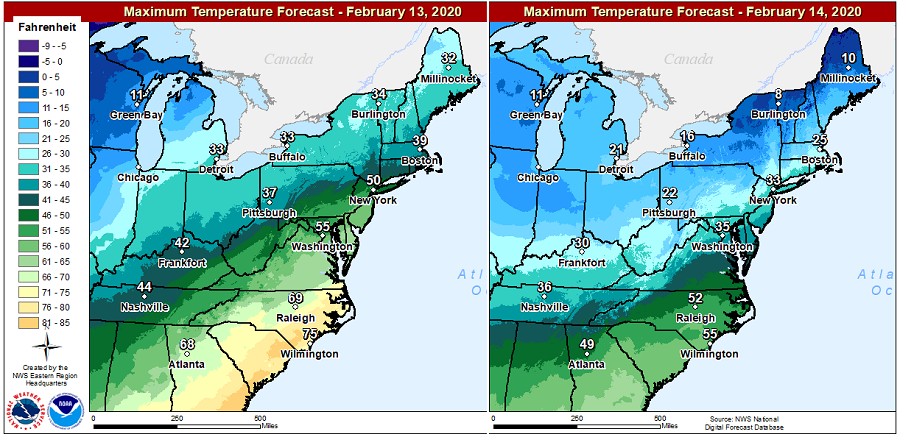
Some of the coldest weather of the season will settle down this Friday and Saturday in the northeast, but as has been the case with this entire winter, it won’t last long …and won’t linger around long enough to meet up with the next storm threat.
The reason for this winter weather pattern is due to the Arctic Oscillation. The Arctic Oscillation, or AO for short, is a pattern in which atmospheric pressure at polar and middle latitudes fluctuates between negative and positive phases. The negative phase brings higher-than-normal pressure over the polar region and lower-than-normal pressure at about 45 degrees north latitude. The negative phase allows cold air to plunge into the Midwestern United States and western Europe, and storms bring rain to the Mediterranean. The positive phase brings the opposite conditions, steering ocean storms farther north and bringing wetter weather to Alaska, Scotland and Scandinavia and drier conditions to areas such as California, Spain and the Middle East. This winter season, the AO has been remarkably positive and hasn’t shown signs of any wavering.
After a cold front pushes through the eastern U.S. today, modified polar air will arrive in the northeast. Late in the weekend and into early next week, the weather pattern will become more zonal with systems quickly moving from west to east across the country. The zonal pattern will also lead to moderating temperatures as the cold air for tomorrow and Saturday is pushed off-shore.
By late Monday and into Tuesday, a new trough of low pressure will dig into the Plains, helping to amplify a ridge in the southeast, which in turn drawns milder air up the eastern coastal plain. As such, temperatures will be unseasonable mild again as that next storm threat arrives, keeping snow out of the I-95 forecast for next week.
