• Skip to primary navigation
  • Skip to main content
  • Skip to primary sidebar

Weatherboy

Weatherboy Weather News, Maps, RADAR, Satellite, and Forecasts.

  • Local
  • Earth Science News
  • RADAR
  • Current Warnings
  • Satellite
  • Current Maps
  • Forecast Maps
  • Video

Tornado Threat Grows Tonight into Tomorrow

by Weatherboy Team Meteorologist - April 8, 2020

The convective outlook released by the National Weather Service Storm Prediction Center shows a chance for severe thunderstorms in darker green (top, today; bottom, tomorrow), with areas in yellow and orange indicative of an even more substantial threat. Image: weatherboy.com


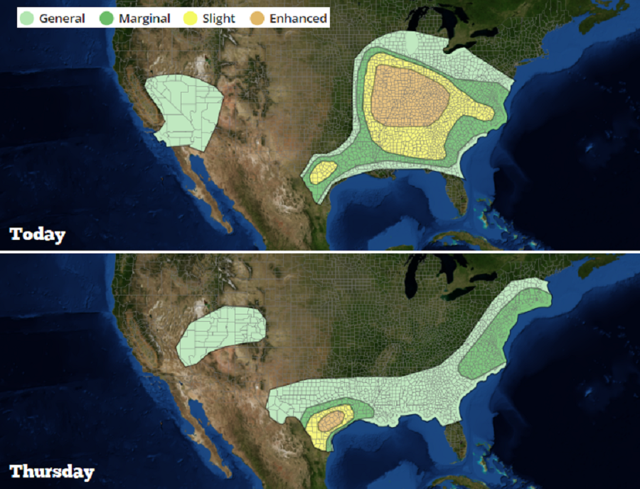
A very large area of severe weather continues to unfold over portions of the Mississippi and Ohio Valleys tonight, setting the state for not only a violent night, but a continued threat for tomorrow. Damaging wind gusts, large hail, and tornadoes are possible here; nighttime tornadoes can be especially lethal since many are asleep and aren’t aware Tornado Warnings are issued.

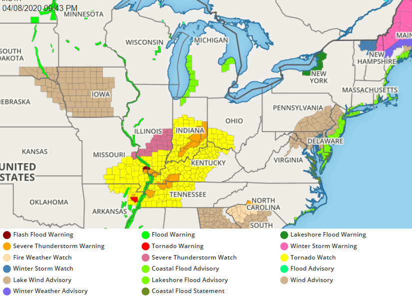
The National Weather Service has issued Tornado Watches across a large area tonight. Tornado Warnings are also being issued within the Watch area, which expands across southern Illinois, central and southern Indiana, southern Ohio, western and central Kentucky and Tennessee, southeastern Missouri, and northwestern Arkansas. In addition to Tornado Warnings, Severe Thunderstorm Warnings have also been issued at times.


A variety of weather watches and warnings are in effect due to this latest severe weather outbreak. Image: weatherboy.com


Many weather features are responsible for this latest severe weather outbreak. A subtle shortwave trough over the Great Lakes is moving south and east. The southern extension of this feature is in the mid-Mississippi Valley while a cold front is located from central Indiana southwestward into south-central Illinois. It is along this front that  a band of strong to severe thunderstorms are firing up.


Don’t be that duck!#TornadoWatch #TornadoWarning #Tornado pic.twitter.com/hFRBeodcv6

— the Weatherboy (@theWeatherboy) April 15, 2019

The threat of severe thunderstorms and isolated tornadoes will linger into the overnight period tonight. The threat of severe weather will then shift to the East Coast tomorrow. For now, the National Weather Service’s Storm Prediction Center believes the greatest threat of severe weather on Thursday will extend from southeastern New England through the metro New York City area down into Philadelphia, Baltimore, Washington, DC and eastern Virginia and North Carolina.


Primary Sidebar

Sponsored Ad

Search

Latest News

  • Igloo Cooler Recalled Due to Amputation / Crushing Threat
  • Longtime TV Meteorologist Fired
  • Spacecraft Launched by Soviet Union in 1972 Crashed Back on Earth Today
  • Strong Tennessee Earthquake Reported by 35,000+ People
  • Updated Crash Forecast Puts Eastern U.S. on Alert from Soviet Union Spacecraft
  • Soviet Union Spacecraft Crash Zones Updated; NJ/NY/PA/MI at Increased Risk
  • Over 2,000 People Report Shaking from Virginia Earthquake
  • Morning Earthquake Strikes Heart of New Madrid Seismic Zone in Missouri Today
About | Careers | Contact | Contests
Terms | Privacy | Ad Choices
Weatherboy is a (R) Registered Trademark of isarithm LLC, All Rights Reserved.
All content herein is Copyright by Isarithm LLC 1997-2022