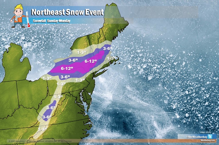
After a tease of milder spring conditions on Friday, snow is likely to fall over portions of New England Sunday into Monday. Some of the snow could be heavy, but the accumulating snow should stay away from the I-95 corridor around New York City and Philadelphia and points south and east.
Friday will feature a surge of mild air moving northeast from the southeast, bringing very warm temperatures into portions of the Mid Atlantic and scattered rain shower and thunderstorm activity. By Saturday, that weather system will clear the region, allowing for dry, colder air to arrive ahead of the next storm system.
A new surface low tracking east-northeastward from the mid-Atlantic coast on Sunday will move offshore, southeast and east of the traditional “benchmark” south of Cape Cod where northeast snowstorms usually form. It appears this low pressure system will be relatively weak initially as it tracks offshore and only deepens as it pulls away. The associated upper-level trough will be attempting to deepen and amplify as it crosses the East Coast Sunday night, but generally looks too progressive to result in a stronger coastal storm closer to shore.
Because of these variables, a major winter storm is unlikely; the storm is too south and east, too weak, and intensifies too late to be problematic for the entire Northeast and Mid Atlantic. While places like New York City and Philadelphia will escape measurable snow, a moderate snowfall is still expected over interior New England as just the right amount of cold air and moisture comes together there. To the south, around New York City, Long Island, New Jersey, and points south from there, it won’t be could enough to support snow at the start of this system. As such, rain will move in later Sunday into this area.
A rain/snow mix is also possible in northeastern Pennsylvania, the Poconos, and far northwest New Jersey. During the night, the mixed precipitation will change to snow from northwest to southeast before the precipitation ends around daybreak Monday morning. While colder air will be wrapping in behind the system, the air will also be progressively drier. As a result, while a few snowflakes are possible south of the Poconos and northwest New Jersey, no accumulating snow is expected there.
But north of there, where precipitation falls entirely as snow, several inches of snow are possible. As much as 6-9″ of snow is possible around the Pennsylvania/New York state border, the higher terrain of western Massachusetts, and portions of southern Vermont and New Hampshire. 3-6″ is possible outside of this heavier snow area and across the higher terrain of West Virginia.