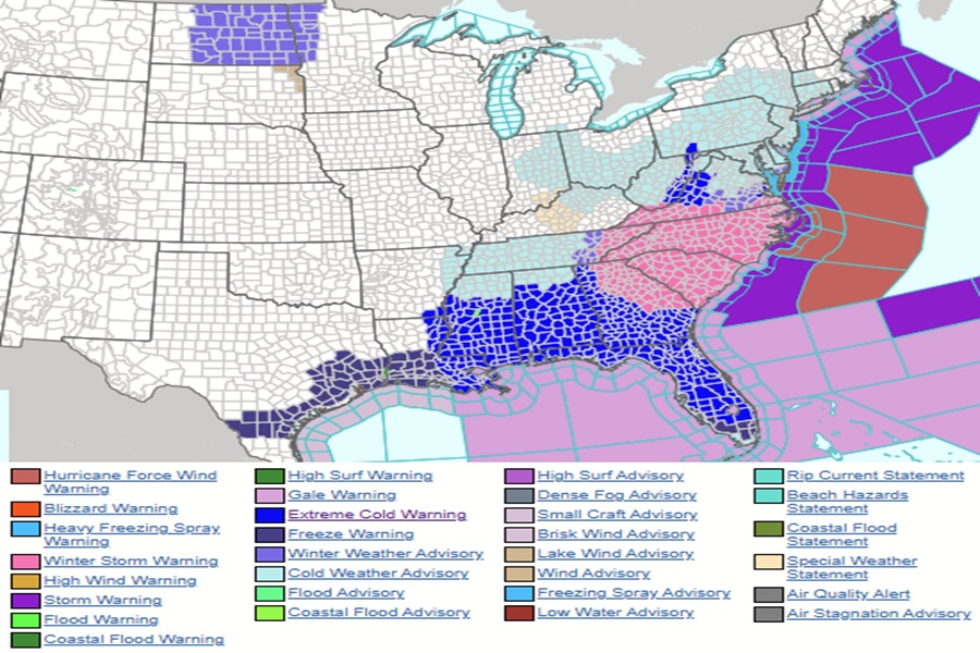
Another wintry weekend is here for the second weekend in a row across portions of the eastern and southeastern United States, with Winter Storm Warnings up for heavy snow in portions of the Mid Atlantic and Extreme Cold Warnings from Texas to Florida. With heavy snow and strong winds, blizzard conditions are impacting portions of the east coast today into tomorrow, making travel extremely difficult.
The explosively deepening coastal cyclone will continue to bring moderate to heavy snow, high winds, and possibly blizzard conditions for
the Carolinas through tonight. An intense surge of arctic air behind the coastal storm will send below freezing temperatures down toward South Florida by Sunday morning.
According to the National Weather Service, a compact, very anomalously cold core low is coming through the Ohio Valley currently; the clash with warm Caribbean/Western Atlantic air is resulting in a few surface cyclones across the Sargasso Sea and Coastal Carolinas and north of the Bahamas. As the lows consolidate, very rapid strengthening will result in a very powerful gale or Nor’easter. This storm has the potential for hurricane force gusts as the low tracks along the southern gradient of the Gulf Stream and out into the Northwest Atlantic by Monday.
High pressure will shift this coastal storm more east than north, sparing the I-95 corridor from Washington DC north of any snow.
While the trends continue to push the storm more out to sea, there remains some potential for sizable snow across Nantucket Island and portions of Cape Cod with 2-4″ totals possible along with the high winds, leading to high probability for blowing snow/white out conditions.
In the wake of the Nor’easter, bitterly cold Arctic air will continue to surge southward, with a large portion of the Deep South and nearly all of peninsular Florida under extreme cold warnings expected later today through Monday morning. Low Maximum temperatures only in the 20s-30s, nearly 25-30 degrees below normal are expected across the Tennessee River Valley, Deep South, Carolinas and southern Mid-Atlantic.
Further records will expand into Florida Sunday with overnight lows into the upper teens and low 20s across northern and central peninsula, bringing coldest air in nearly a decade plus. Daily highs in the 40-50s across Southern Florida including the Keys will also help to break long-standing records. Combined with the higher winds behind the exiting storm, extremely cold wind chills are probable, including sub-zero values over much of the South, and in the -20s in parts of the Ohio Valley especially Sunday morning.
“Bundle up and cover your mouth if you are outside, ensure pets and animals have protection from the cold, and continue to take steps to prevent frozen pipes,” advises the National Weather Service.
