It appears Old Man Winter may be trying to prank us: a snowstorm will impact portions of the northeast on April 1, the day known as April Fool’s Day. But the cold and snow is no joke: models are in good agreement that colder, snowier conditions will arrive at the start of the new month.
On Wednesday, low pressure near the Canadian/U.S. border in the northeast will cause a slow moving cold front to approach the Mid Atlantic late tomorrow. It is expected that low pressure will develop along the front as it crosses the Ohio Valley during the afternoon. Showers will then spread east during the first half of tomorrow. The rain could be heavy at times during the afternoon with some improving upper dynamics and decent moisture arriving across region. Instability will not be a big factor, but a few localized thunderstorms could develop over portions of southern New Jersey, Delaware, Maryland, and eastern Virginia. Rain totals of 0.5-1.5″ are expected through the day.
On Wednesday, from the Pennsylvania/New York and New Jersey / New York border south, it will be mild and humid with highs reaching the low/mid 60s in most areas with 50s for the far north and perhaps some near-70 degree temps away from the coast in Delaware. Winds will be mostly south to southwest at 10 to 15 mph on Wednesday.
On Wednesday night, the slow moving front will continue to move east while the low along it continues to deepen. The speed of the system will determine the eventual precipitation amounts, but at this time, it looks like another 0.75-1″ of rain is expected with the highest amounts across the I-95 corridor areas.
However, as that cold front reaches the coast, much colder air will filter in, changing rain to snow over northeastern Pennsylvania and northwestern New Jersey. There, only light amounts of snow are expected Wednesday night into Thursday morning.
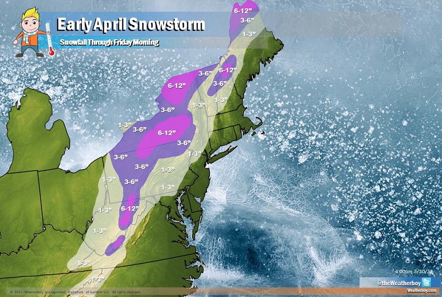
However, north and west of there, there will be colder air and more moisture for the system to work with. As low pressure at the surface tracks north and east through New England and the the lagging upper level trough swings through and closes off, snow will fall, heavy at times, during the first half of Thursday. While the precipitation should wind down by Thursday afternoon, scattered light snow showers and flurries are possible.
Up to 6-12″ of snow is possible over the highest terrain of West Virginia, western Upstate New York, northern Maine, and some of the higher elevations of New Hampshire. 3-6″ is possible outside of these heavy snow areas. Snow will be very wet and heavy in nature.
As cold air pumps into the northeast on 15-20 mph winds gusting to 25-35 mph, it will feel rather raw and wintry across much of the northeast on Thursday. By Thursday night and early Friday, the elongated closed upper level low will slowly drift from the Great Lakes region into the northeast while low pressure at the surface slowly drifts to the Canadian Maritimes. This will keep the area under improving albeit cold conditions.

It doesn’t look like Old Man Winter will linger long, however. Early next week, it appears that the weather pattern will become increasingly blocked over the north Atlantic which should act to stall the upper level low south and east of the Canadian Maritimes while ridging builds over eastern Ontario into Quebec. This should result in continuing dry and seasonably warm weather for the Northeast and Mid Atlantic with a surface high pressure setting up near the east coast.
