The National Hurricane Center now believes it is likely that a tropical or subtropical depression will form off of the southeast U.S. coast in the coming days; if it becomes a named storm, it would be called Arthur. While the Atlantic Hurricane Season doesn’t officially start until June 1, often times depressions and tropical/subtropical storms do form in May. The Eastern Pacific Basin already got a jump-start, having a record-breaking pre-season system weeks ago.
The disturbance being tracked now consists of an area of cloudiness and thunderstorms located over the Straits of Florida. It is forecast to spread northeastward during the next day or two. According to the National Hurricane Center in Miami, environmental conditions are expected to become conducive for development, and this system is likely to become a tropical or subtropical depression or storm this weekend when it is located near or north of the northwestern Bahamas. The latest Tropical Outlook suggests that the system is forecast to move generally northeastward over the western Atlantic early next week. Regardless of development, the disturbance is expected to bring locally heavy rainfall and gusty winds to portions of southeastern Florida and the central and northwestern Bahamas over the next couple of days.
In the latest Tropical Outlook from the National Hurricane Center, they believe there is a 40% chance that the system will form over the next 48 hours; those odds increase to 70% over the next 5 days.
While the system moves along the U.S. southeast coast, there are questions about it’s future track. A non-tropical low will be moving across the eastern United States in the coming days and it will have some kind of interaction with this new system. It could help boot the storm out to sea or help draw it closer to the Mid Atlantic Coast. With such uncertainty, residents of the U.S. East Coast should closely monitor this developing storm system this weekend and into the early part of next week.
While the Atlantic Hurricane Season doesn’t start until June 1, the National Hurricane Center is urging people to be properly prepared for the upcoming season. While NOAA won’t release their official seasonal outlooks until later this month, many other leading tropical weather forecasters are calling for a busy Atlantic hurricane season. With a busy season possible ahead, the National Hurricane Center recommends that people develop a written action plan, consider helping neighbors in their planning process, make sure their homes are strengthened prior to being threatened by a tropical system, make sure insurance is in-order, stock up on essential supplies, develop an evacuation plan, and ultimately identify and determine any risks you may face from a storm.

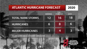
Experts with the Tropical Meteorology Project at CSU believe the upcoming hurricane season will be a particularly busy one with increased chances of a landfalling tropical system compared to typical seasons. NOAA is scheduled to unveil their official outlook for the season next week for both the Atlantic and Central Pacific hurricane basins and seasons.