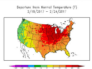
Meteorologists look at weather patterns around the globe to help determine short and medium range forecasts; one such pattern explored is the Bering Sea Rule, and it suggests that incredible warmth will return to much of the United States come mid-March. The unusual warm weather could also be joined by another severe weather outbreak.
Joseph Renken, who developed a long-range forecasting tool called the Bering Sea Rule (BSR), believes current signals suggest a wild and warm March. “Severe thunderstorms look likely on the tenth and eleventh of the month from the central Plains, eastward into the Mississippi and Ohio Valleys and extending into the mid-Atlantic region.” Renken further explained, “A low pressure system will form over the lee of the Rockies and over the Plains of Colorado, and will head east-northeastward. Its associated cold front will push into the Plains and head eastward and will be the cause of this severe weather outbreak.” Renken believes the pattern setting up won’t just create one severe weather outbreak. “Even though climatologically-normal temperatures are rising very fast in the middle of the month, we can expect temperature departures to be in the 10-20 degrees above normal range across much of the central and eastern U.S., which are very similar departures to what the same area of the country saw over the mid and late part of February.”
Renken believes that another anomalous warm spell that could rival February’s is possible. “Around the 27th of February, the combination of high pressure just to the south of Kodiak Island and a strong storm between Attu Island and the Kamchatka peninsula will exaggerate the ridging over the east Aleutian Island chain. Another storm a few days later, as the calendar flips to March, near the Sea of Oshkosh, will cause the ridge to become even stronger and to be forced westward. With the 18-day lag that the BSR is currently showing, this ridge should teleconnect to a strong ridge over the central part of the U.S. starting around the 14th of March.”

If the forecast comes to fruition, such a ridge over the central US will be associated with incredible warmth. Temperatures in the 80s and even 90s will be common for much of the southern and central Plains as well as the adjacent Mississippi valley region. Renken adds that the configuration of this warm air mass will be slightly different, which could have implications for New England. “There is a difference between this upcoming ridge and the one that was associated with all the warmth of the past few weeks as it will be centered a bit further to the west. This will leave the Northeast, particularly New England, more at risk of some backdoor cold fronts that will hold back the warming the more northeast one is.” But with lack of snowcover, anomalously warm southern Canada, and a gradually higher warming sun angle, cold shots for New England likely won’t be too long nor too harsh. “It should only be a matter of time until the warmth from the ridge across the central US is pushed eastward thanks to a continued unusually strong Pacific jet. So while New England may be cooler longer, they too will warm.”, Renken said.
That strong Pacific jet and atmospheric rivers of moisture have blasted the US west coast, especially California, with heavy rain; this evolving weather pattern may help California dry out a bit in March, albeit briefly. As the Pacific jet weakens somewhat, the first part of March will allow places like California to recover from recent heavy, record-breaking precipitation. However, as the Bering Sea ridge weakens, the Pacific Jet will become active again Renken expanded: “The Pacific jet has incorrectly been described as part of the ‘Pineapple Express’ this winter. Generally this winter, that description has been inaccurate. California has been dumped on not because of moisture from the tropics, such as the Pineapple Express, but simply because the strength and persistence of the west to east flow across the Pacific has picked up oceanic moisture that it is forced to drop once it encounters the Sierra Nevadas.” Don’t put away the umbrellas and snow shovels yet. “As the central ridge flexes its muscles in a few weeks, the Pacific jet will yet again lengthen and strengthen. And its aim will continue to be on the Sierra Nevadas of California.” With heavy precipitation returning by mid-March, drought conditions will be further eliminated while threats of floods and other heavy-precipitation-related disasters mount.