Remote Sensing Center
Many in the eastern United States continue to recover from the Blizzard of 2018, a powerful winter storm that brought snow from Florida to Maine, and blizzard conditions from North Carolina to Massachusetts. And while that recovery and dig-out continues, eyes are on the next potential weather systems to impact this hard-hit region again.
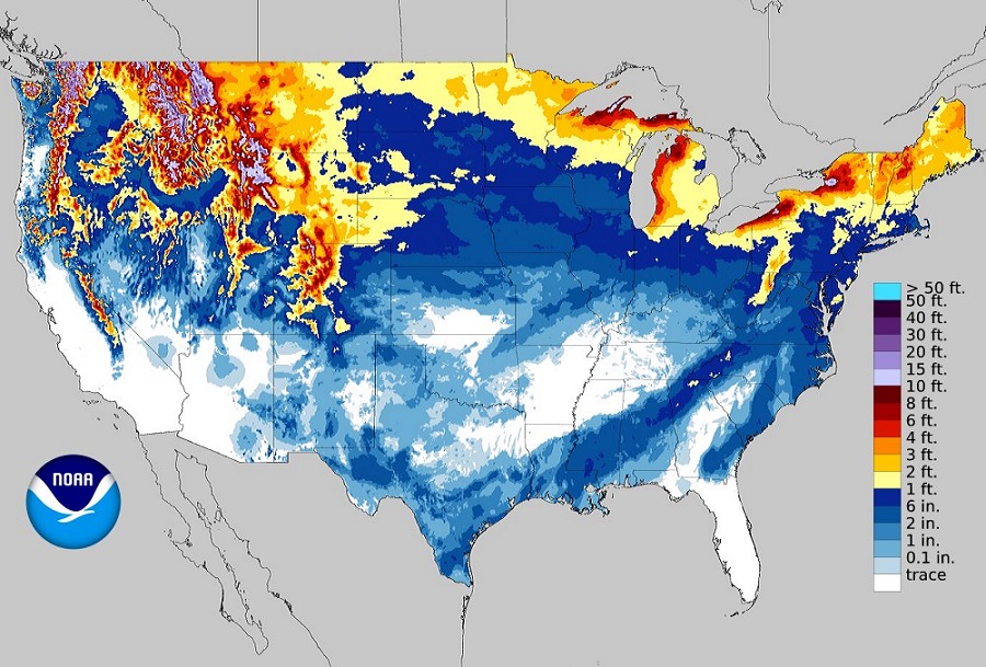
The young winter season has been a busy one, with abnormally cold air locked across a large part of the country, including the deep south. An earlier winter storm brought accumulating snow all the way down to the Texas/Mexico Gulf Coast border, with snow flakes even reported over the northern Gulf of Mexico south of Louisiana. The Sunshine State had Winter Storm Warnings posted on Wednesday; the state known for its warm beaches and fun amusement parks had to deal with accumulating snow and ice. The Rockies have also had their fair share of heavy winter snows, with deep snowpack in excess of 20 feet in some higher elevations. The Northeast, hit hard by the recent Blizzard, has also seen a lot of snow; parts of New England have already accumulated more than 8 feet of snow this season. The Great Lakes region is also active; Erie, Pennsylvania saw over 5 feet of lake effect snow around Christmas last week.
The winter weather pattern appears to stay busy for the next few weeks, with two weather systems of note on the horizon. This weekend, some of the coldest air of the season will spill into parts of the eastern United States, pulling morning wake-up lows to near or below zero degrees in places like the New York City and Philadelphia suburbs. Temperatures will moderate after the weekend deep freeze, setting the stage for the first of two systems of concern.
On Monday and Tuesday, a low pressure system will make its way to the East Coast, dragging a cold front with it to the coast late Monday and early Tuesday. With cold air remaining at the surface and warming occurring aloft with this system, there is the potential for some non-snow precipitation to fall on Monday. It appears that a mix of
rain/snow/sleet is possible from Pennsylvania and New Jersey north into southern New England, a stronger warm layer aloft, some pockets of freezing rain may occur. Warmer air eventually makes it to the surface and most places south of New York State should see some plain rain fall. After the weekend deep freeze, temperatures will be much closer to normal on Tuesday, with highs returning to the 30’s and low 40’s for the heavily populated area around the Mid Atlantic I-95 corridor. Precipitation from this early week system should be relatively light; however, even light amounts of sleet and/or freezing rain could lead to dangerous travel conditions.
After the early-week system exits on Tuesday, high pressure will return to the east again for Wednesday and Thursday. As air masses evolve and another contrast between reinforcing cold air to the north and relatively milder, moist subtropical air to the south, it is likely another winter storm will blossom on Friday. This next storm could eventually evolve into another strong nor’easter, bringing more wind-whipped heavy precipitation and coastal flood threats to the Mid Atlantic and Northeast later Friday into Saturday. It is still too soon to say what precipitation type will fall, and how much and where, but it is likely that the East Coast will indeed be dealing with another storm threat just a week from now.