
Tropical Storm Calvin is on a collision course with Hawaii, expected to impact the Big Island of Hawaii later today, where Tropical Storm Warnings are in effect for the entire island. The National Weather Service office in Honolulu, which is co-located with the Central Pacific Hurricane Center, is warning that damaging wind gusts, flooding rains, rough surf, and even tornadoes are possible as the storm approaches the island this evening into tomorrow.
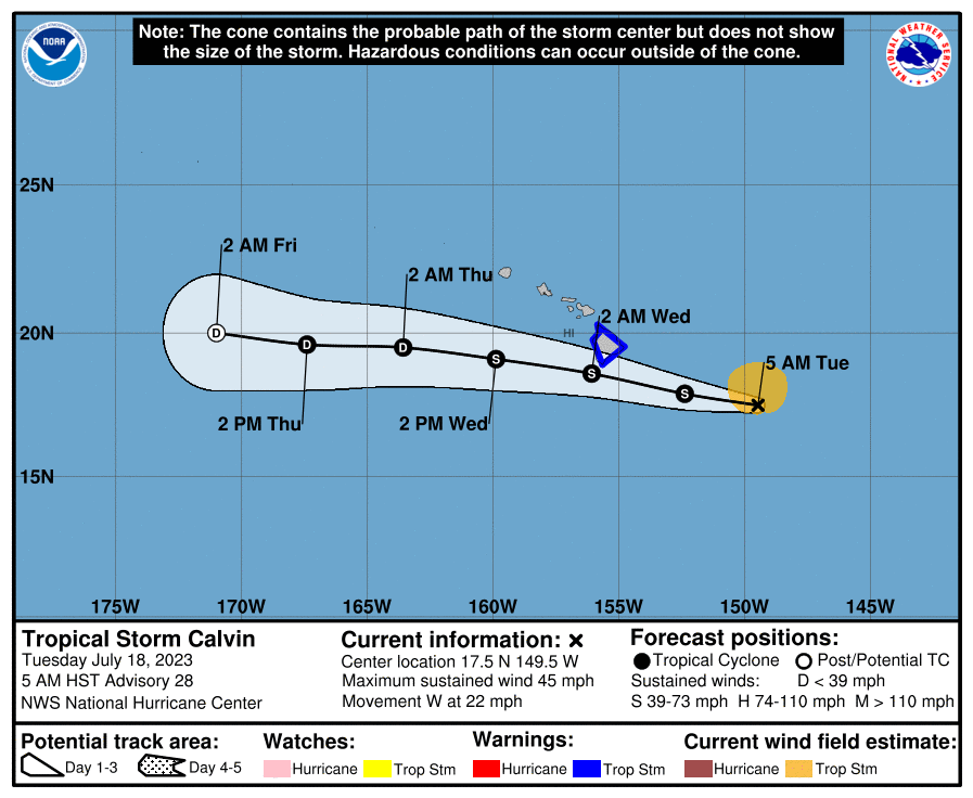
As of the latest update from the Central Pacific Hurricane Center (CPHC), Tropical Storm Calvin was located just 395 miles east-southeast of Hilo on Hawaii’s Big Island and just 605 miles east-southeast of Honolulu on island of Oahu. Maximum sustained winds are 45 mph; the storm is moving to the west quickly at 22 mph with an estimated minimum central pressure of 1002 mb or 29.59″.
With direct impacts likely soon, a Tropical Storm Warning is in effect for the entire island of Hawaii, also known as the Big Island. A Tropical Storm Warning means that tropical storm conditions are expected somewhere within the warning area, in this case within the next 12 to 24 hours.
According to the CPHC, deep convection has been developing near Calvin early this morning, which may slow the weakening trend today. It is even possible for some strengthening to occur prior to landfall although there won’t be a significant change in expected impacts. Once passing near or through the Big Island, Calvin is forecast to gradually weaken tomorrow into Thursday as it slides west well south of the rest of the Hawaiian Island chain.
Tropical-storm-force winds extend outward up to 105 miles from the center and this area could expand as it hits Hawaii Island.
Tropical storm force wind conditions are expected within the warning area starting this evening. “Persons in Hawaii County should complete preparations for tropical storm force wind impacts during daylight hours prior to the onset of tropical storm conditions tonight,” the CPHC said in its latest statement.
Sustained winds of 15-50 mph are expected across the Big Island, with gusts to hurricane strength of 75 mph possible. The highest winds will be along the southeastern and northwestern portions of the Big Island. The winds will be strongest from this evening through Wednesday morning. Winds of this magnitude can create limited damage to porches, awnings, carports, sheds, and unanchored mobile homes. Unsecured lightweight objects will be blown about, so people should take great effort to secure anything outside such as garbage cans, play equipment, yard decorations, or tools and supplies. With these wind speeds, many large tree limbs could be broken off. A few trees may also snap or uproot, but the greatest risk of this happening is where trees are shallow rooted. Some fences and roadway signs could also be blown over at these speeds. Due to the wind and wind damage, some roads could become impassable from debris, particularly within urban or heavily wooded places. Winds will also create hazardous driving conditions on bridges and other elevated roadways. Scattered power and communications outages are likely.
Tropical Storm Calvin will also soak the Big Island of Hawaii, with the eastern, windward side seeing much more water than leeward, western sides of the mountainous island. Storm total rainfall amounts of 4-8″ is expected, with maximum amounts of 10″ possible on the windward side; only 1-4″ is expected on the leeward side of the Big Island, with 1-2″ possible elsewhere in the state with localized higher amounts influenced by higher terrain on neighboring islands. This rainfall could lead to localized flash flooding and mudslides.
Swells generated by Calvin are expected to begin spreading across the main Hawaiian Islands later today and tonight. This will lead to a rapid increase in surf along east facing shores, with high surf continuing into Wednesday. This elevated surf will likely cause life-threatening conditions along exposed shorelines. Even experienced swimmers, surfers, and recreational boaters should remain away from the ocean until the threats pass. Due to the structure of this storm and the geography of the Big Island, no significant storm surge is expected state-wide.
Lastly, the National Weather Service is warning of the possibility for a few tornadoes and/or water spouts, primarily on the Big Island of Hawaii. If a Tornado Warning is issued, the National Weather Service wants people to be ready to shelter
quickly. Most homes in Hawaii do not have basements, so in a Tornado Warning, people should head into the most interior room of the ground floor of their building, stay away from windows, and cover yourself with protective materials like blankets, a pillow, a mattress, and/or even bike helmets. A few places may experience tornado damage, along with
power and communications disruptions; due to tornadic activity, some locations could realize roofs peeled off buildings, chimneys toppled, large tree tops and branches snapped off, shallow-rooted trees knocked over, moving vehicles blown off roads, and small boats pulled from moorings.
Because Tropical Storm Calvin is moving quickly, the storm and its impacts should be relatively short-lived. By Wednesday afternoon, storm conditions will quickly wind down from east to west on the Big Island as rain showers linger elsewhere in the state. By Wednesday evening, conditions may even be ripe for a spectacular, colorful sunset on Hawaii’s Big Island.
