A catastrophe is imminent for portions of Florida and the broader southeastern United States as Major Hurricane Helene is about to make landfall soon on the “Big Bend” area of the Sunshine State. The hurricane continues to intensify; with 140 mph sustained winds and higher gusts over 155 mph, Helene is now a major Category 4 hurricane on the Saffir-Simpson hurricane wind scale.
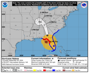
As of 10 pm, Major Hurricane Helene was 65 miles west-northwest of Cedar Key and 65 miles south of Tallahassee, Florida. With maximum sustained winds of 140 mph and a minimum central pressure of 939 mb or 27.72″, the massive storm is moving to the north-northeast at 24 mph. Helene is an exceptionally large hurricane; damaging tropical storm force winds extend 275 miles to the northeast of the center, 310 miles southeast of the center, 115 miles to the southwest of the center, and 135 miles to the northwest of the center.
The fast forward speed when Helene moves inland will result in a far inland penetration of strong winds over parts of the southeastern United States, including strong gusts over the higher terrain of the southern Appalachians. Accordingly, a higher-than-normal gust factor is indicated in the official forecast while Helene is inland.
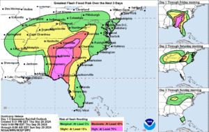
Because of the size, intensity, and motion, a very large area of the southeastern United States will see epic rainfall amounts which will lead to widespread flooding issues far from the coast. As heavy rain hits the mountainous area of the southern Appalachians, landslides are possible too.
A catastrophic and deadly storm surge will occur along portions of the Florida Big Bend coast, where inundation could reach as high as 20 feet above ground level, along with destructive waves. There is also a danger of life-threatening storm surge along the remainder of the west coast of the Florida Peninsula.
Those that didn’t evacuate may not survive. The Taylor County Sheriff’s Office is urging those who didn’t evacuate to help identify their body before they are killed by the storm surge. “If you or someone you know chose not to evacuate, PLEASE write your name, birthday, and important information on your arm or leg in a PERMANENT MARKET so that you can be identified and family notified,” the Sheriff’s Office wrote in a Facebook update about the emergency.
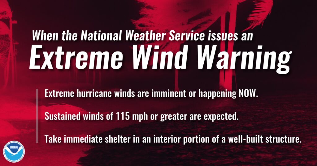
Potentially catastrophic hurricane-force winds are expected within the eyewall of Helene and will spread inland over portions of northern Florida and southern Georgia when Helene makes landfall in the Florida Big Bend region this evening. “Persons in these areas should be prepared to take shelter in the interior portion of a well-built structure and remain sheltered until after hazardous conditions pass. You may need to remain sheltered after the storm due to downed trees and power lines, as well as flooding, in the area,” warns the National Hurricane Center.
Damaging wind gusts will penetrate well inland over portions of Georgia and the Carolinas tonight, particularly over the higher terrain of the southern Appalachians. Residents in these areas should be prepared for the possibility of long-duration power outages.
The National Hurricane Center warns, “If you use a generator after the storm, be sure it is placed outside at least 20 feet away from doors, windows, and garages to avoid deadly carbon monoxide poisoning.”
Catastrophic and life-threatening flash and urban flooding, including numerous significant landslides, is expected across portions of the southern Appalachians through Friday. Considerable to locally catastrophic flash and urban flooding is likely for northwestern and northern Florida and the Southeast through Friday. Widespread significant river flooding and isolated major river flooding are likely.
Widespread tornadoes are likely too, with dozens of Tornado Warnings issued throughout the southeast today already. More tornadoes are likely as the storm moves inland over the next 24 hours.
