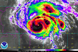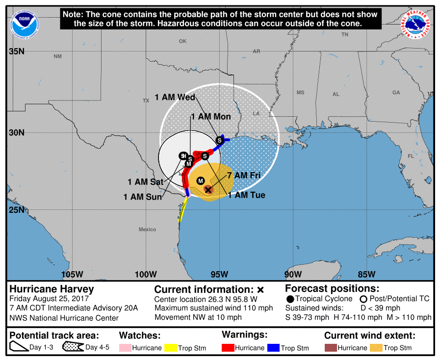
A catastrophe is imminent as Hurricane Harvey inches closer to the coast of Texas; Hurricane Harvey is expected to be the first major hurricane to strike the United States in 4,323 days; it is also expected to dump more rain than any tropical cyclone before it, including Tropical Storm Allison which devastated the Houston metro area in June of 2001. Efforts to protect life and property should be complete and coastal residents and those in areas likely to flood should head far inland to areas expected to remain high and dry.
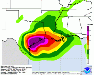
A nearly unimaginable 2-3 feet or more of rain is expected to fall on the Lone Star State as Hurricane Harvey stalls over the region for the next several days. More than 2 feet of rain is expected in Corpus Christi and Houston and as the storm gradually shifts towards Louisiana next week, more than a foot of rain will be possible in places like New Orleans, Lake Charles, and Baton Rogue. “In the last 30 years, inland flooding has been responsible for more than half the deaths associated with tropical cyclones in the United States, ” says Ed Rappaport, Acting Director, National Hurricane Center. ” Meteorologist Eric Blake, also from the National Hurricane Center, expresses awe of the rainfall amounts expected from Hurricane Harvey: “I don’t think I have ever seen a heavier rain forecast from the National Weather Service Weather Prediction Center in my life- the size of the 20+ inches of rain area is staggering.” Flooding from Hurricane Harvey alone will be catastrophic over a large area; expect tens of thousands of homes to be destroyed or damaged.

Flooding from rainfall isn’t the only expected threat: destructive winds and a large storm surge are also forecast to destroy property too. Hurricane Harvey is forecast to arrive at the coast late Friday / early Saturday with maximum sustained winds of at least 120mph, making it a very strong Category 3 hurricane. Storms with 130mph winds are considered Category 4 hurricanes on the Saffir-Simpson scale. The storm surge will be just as catastrophic, with the surf expected to rise to 10-12 feet with 10’+ waves on top of it; the storm surge will completely inundate coastal communities near and just north and east of the location of landfall.
When all is said and done, a huge disaster in Texas is expected. Near the expected landfall zone, we expect complete or near complete destruction at the coast. Away from the landfall zone, we expect catastrophic flooding for the Houston Metro area and most areas extending west and south towards the point of landfall. Here, major freeways will be under water for a significant amount of time, blocking the ability of food, medicine, and fuel to pass into the damage areas. Power will be out for many people for a prolonged period of time and city water supplies are likely to be unavailable. Without electricity or access to/from flood-free streets and highways, cash will run on short supply with banks and ATMs closed.

There are numerous hazards that will impact land as Harvey approaches: incredible rainfall and flooding, storm surge, destructive winds, dangerous surf, and tornadoes.
RAINFALL:
Harvey is expected to produce total rain accumulations of 15 to 25 inches and isolated maximum amounts of 35 inches over the middle and upper Texas coast through next Wednesday. During the same time period Harvey is expected to produce total rain accumulations of 7 to 15 inches in far south Texas and the Texas Hill Country over through central and southwest Louisiana, with accumulations of up to 7 inches extending into other parts of Texas and the lower Mississippi Valley. Rainfall from Harvey will cause devastating and life-threatening flooding.
STORM SURGE:
The combination of a dangerous storm surge and the tide will cause normally dry areas near the coast to be flooded by rising waters moving inland from the shoreline. The water is
expected to reach the following heights above ground if the peak surge occurs at the time of high tide:
- North Entrance Padre Island National Seashore to Sargent…6 to 12 ft
- Sargent to Jamaica Beach…5 to 8 ft
- Port Mansfield to North Entrance Padre Island National Seashore…5 to 7 ft
- Jamaica Beach to High Island…2 to 4 ft
- Mouth of the Rio Grande to Port Mansfield…2 to 4 ft
- High Island to Morgan City…1 to 3 ft
The deepest water will occur along the immediate coast near and to the northeast of the landfall location, where the surge will be accompanied by large and destructive waves. Surge-related flooding depends on the relative timing of the surge and the tidal cycle, and can vary greatly over short distances. For information specific to your area, please see products issued by your local National Weather Service forecast office.
WIND:
Hurricane conditions are likely within the hurricane warning area later today, In Category 3 hurricanes, well-built framed homes may incur major damage or removal of roof decking and gable ends. Many trees will be snapped or uprooted, blocking numerous roads. Electricity and water will be unavailable for several days to weeks after the storm passes. In Category 4 hurricanes, catastrophic damage will occur. Well-built framed homes can sustain severe damage with loss of most of the roof structure and/or some exterior walls. Most trees will be snapped or uprooted and power poles downed. Fallen trees and power poles will isolate residential areas. Power outages will last weeks to possibly months. Most of the area will be uninhabitable for weeks or months.
SURF:
Swells generated by Harvey are likely to affect the Texas, Louisiana, and northeast Mexico coasts by Friday. These swells are likely to cause life-threatening surf and rip current conditions.
TORNADOES:
Isolated tornadoes are possible across portions of the middle and upper Texas coasts today and early tomorrow.
Residents in or near watch/warning areas for Hurricane Harvey should act on their hurricane action plans if they haven’t already. People along any Gulf or Atlantic coastline, and Hawaii, should be prepared every hurricane season; with Harvey here, people should ensure they are ready for the arrival of a potential disaster wherever they may be.
Experts believe this Atlantic Hurricane Season, which runs through to the end of November, will be a busy one. Dr. Phil Klotzbach and the experts at Colorado State University updated their seasonal outlook again on July 5, showing a much more active than normal season expected. The National Oceanic and Atmospheric Administration (NOAA) also released their own forecast which shows this hurricane season to be likely more active than others.