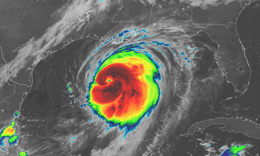
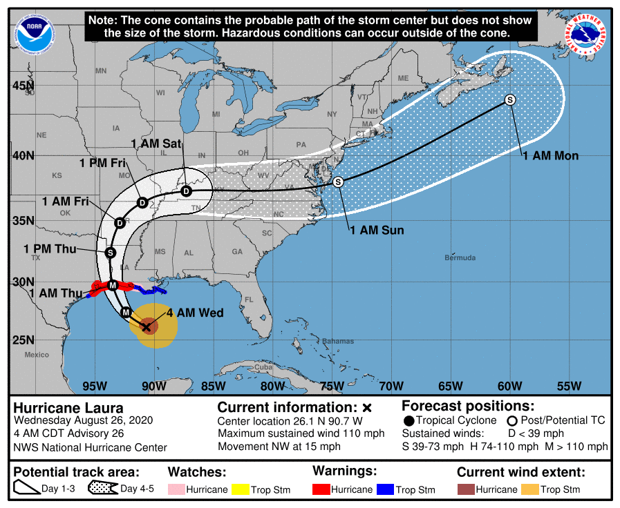
Major Hurricane Laura, expected to be a full-fledged Category 4 hurricane on the Saffir-Simpson wind scale, is due to crash into the central Gulf Coast this evening, bringing a catastrophic landfall to portions of Texas and Louisiana. The National Hurricane Center (NHC) is forecasting a life-threatening storm surge, extreme winds, and a very large area of flash flooding.
In addition to getting stronger through a period of violent, rapid intensification, Laura is also becoming larger. Hurricane-force winds now extend outward up to 70 miles from the center and tropical-storm-force winds extend outward up to 175 miles. This area will increase somewhat as it approaches the coast.
Maximum sustained winds inside Laura now are at 110 mph with gusts to 125 mph but should increase to at least 130 mph by this afternoon, with some gusts expected to be at or above 160 mph. To put things in comparison, a catastrophic Category 5 hurricane has maximum sustained winds greater than 157 mph.

The storm surge from Hurricane Laura could be extreme. The combination of a dangerous storm surge and the tide will cause normally dry areas near the coast to be flooded by rising waters moving inland from the shoreline. Due to the flat, swampy nature of the coastline in this part of the country, some storm surge flooding can extend up to 30 miles inland away from the coast in portions of southwestern Louisiana and far southeastern Texas. Worse, it appears the storm will impact the coast near the time of high tide which could make conditions even worse. A very large area could see storm surge flooding in excess of 8-12′; some areas could see a storm surge of 10-15′. The deepest water will occur along the immediate coast near and to the right of the landfall location, where the surge will be accompanied by large and destructive waves. Surge-related flooding depends on the relative timing of the surge and the tidal cycle, and can vary greatly over short distances. If people don’t heed evacuation orders in the storm surge area, storm surge could become the primary reason for storm fatalities here.
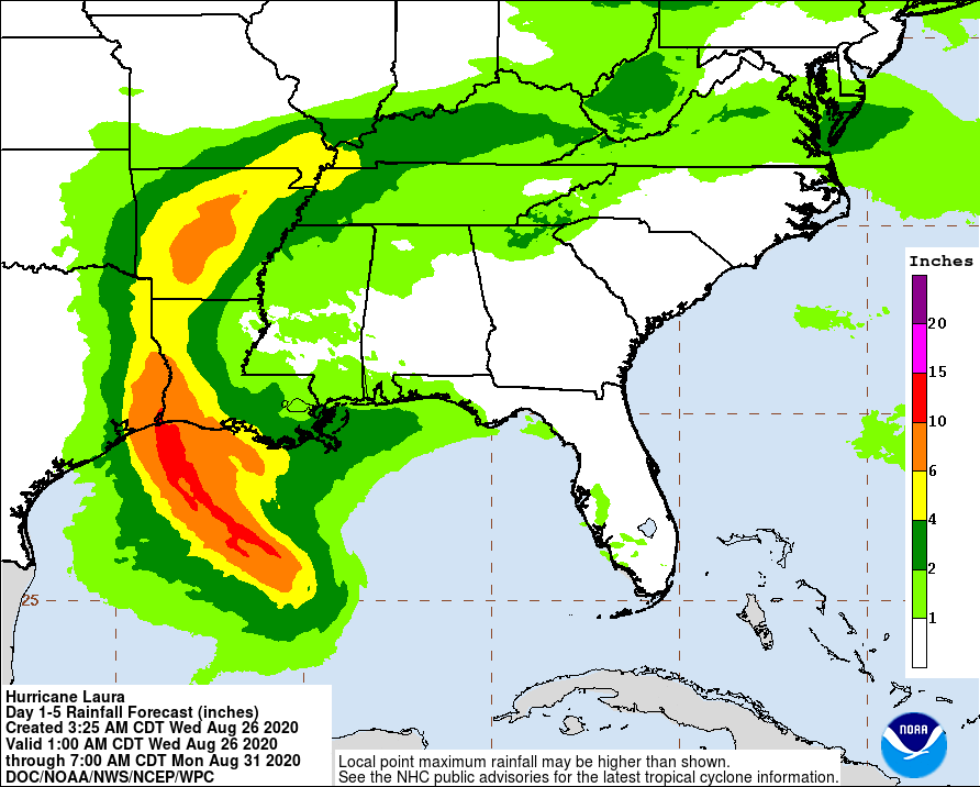
From this afternoon through to Friday, Laura is expected to produce rainfall totals of 5-10″, with isolated maximum amounts of 15″ possible across portions of the northwestern Gulf Coast from western Louisiana to far eastern Texas, and northward into much of Arkansas. Over the lower to middle Mississippi Valley from central Louisiana into western Tennessee and Kentucky, and southeastern Missouri, 2-4″ of rainfall with isolated totals of 6″ are expected. This rainfall will cause widespread flash and urban flooding, small streams to overflow their banks, and minor to isolated moderate river flooding. By late Friday into Saturday, portions of the Tennessee and Ohio Valley could see 2-4″ inches with locally higher amounts as tropical moisture from Laura moves through the region. This rainfall could lead to localized flash and urban flooding along small streams. The National Weather Service reminds, “turn around, don’t drown; never drive through flood waters.”
Hurricane-force wind conditions are expected in the hurricane warning area tonight and Thursday. Tropical storm conditions are expected to reach the coast in the hurricane warning area late today or tonight, and are expected in the tropical storm warning area tonight and Thursday. Hurricane-force winds and damaging wind gusts are also expected to spread well inland into portions of eastern Texas and western Louisiana early Thursday.
In addition to wind damage from hurricane and tropical storm force winds, numerous tornadoes are likely, with the greatest threat of tornadoes on the eastern side of the storm. The tornado threat arrives this evening over Louisiana, far southeast Texas, and southwestern Mississippi. Tomorrow, the risk of tornadic action will move into northern Louisiana, Arkansas, and the rest of western Mississippi.
Swells produced by Laura are affecting the U.S. Gulf coast from the west coast of Florida to Louisiana and are expected to reach the coast of Texas and northeastern Mexico today. These swells are likely to cause life-threatening surf and rip current conditions. Even experienced swimmers and surfers are urged to stay out of the Gulf of Mexico until dangers associated with Hurricane Laura are long gone.
