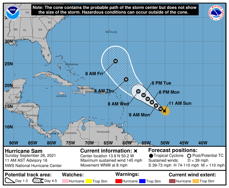
Major Hurricane Sam, now a high-end Category 4 hurricane on the Saffir-Simpson hurricane wind scale, continues to march west-northwest over open water. It is becoming more likely that Sam will miss the U.S. East Coast; however, Bermuda could still see a direct strike. And while Sam is more likely to avoid the United States, its future track may make Florida and the U.S. East Coast vulnerable to other tropical cyclones over the next week.
As of the latest advisory from the National Hurricane Center (NHC), Sam was located roughly 905 miles east-southeast of the Northern Leeward Islands. Moving to the west-northwest at 8 mph, it has powerful maximum sustained winds of 145 mph and higher gusts. The estimated minimum central pressure is down to 943 mb or 27.85″.
The NHC expects Sam to continue to move west-northwest today and gradually turn to the northwest tomorrow. Through the midweek period, Sam is expected to turn more to the north.
As Sam travels over the open waters, the NHC expects some fluctuations in its strength. However, as it moves north, it is expected to weaken as it encounters cooler sea surface temperatures.
The official five day forecast from the National Hurricane Center keeps Sam away from any land. Extended computer forecast guidance suggests it will miss the U.S. East Coast and perhaps the Canadian Maritimes too; however, Bermuda could see direct impacts of the storm over time. It is important that no one let their guard down until the threat completely passes.
If Hurricane Sam were to move north and eventually northeast away from the United States, it could open the door for a new tropical cyclone to take shape in the Caribbean or Bahamas. If that were to happen, such a new tropical cyclone could impact Florida or the U.S. East Coast. But as with the future track of Sam, it is too soon to say if/where a new system could develop and eventually track.
Because Sam isn’t forecast to impact any land for at least the next 5 days, there are no watches or warnings up anywhere for it at this time.