• Skip to primary navigation
  • Skip to main content
  • Skip to primary sidebar

Weatherboy

Weatherboy Weather News, Maps, RADAR, Satellite, and Forecasts.

  • Local
  • Earth Science News
  • RADAR
  • Current Warnings
  • Satellite
  • Current Maps
  • Forecast Maps
  • Video

Cinco de Mayo Wash-Out

by Weatherboy Team Meteorologist - May 5, 2017

Heavy precipitation will drench portions of the east coast over the next 72 hours. Dark green represents 2" rain while orange reflects 3".  Map: Weatherboy.com
Heavy precipitation will drench portions of the east coast over the next 72 hours. Dark green represents 2″ rain while orange reflects 3″. Map: Weatherboy.com

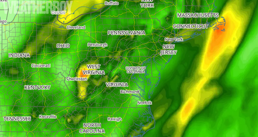
Those looking to step out and enjoy Cinco de Mayo festivities will need their umbrellas in much of the eastern US; a rowboat may even be more appropriate for some. A complex, slow-moving low pressure system will bring heavy downpours and drenching thunderstorms over a large area.


There will be scattered snow shower activity in the northeast this weekend. While snowflakes may be seen in places like northern New Jersey, accumulations will be restricted to the higher terrain of Pennsylvania, New York, and nearby places. Even so, accumulations will be light; gray represents a trace while shades of light blue represent 1-3".
There will be scattered snow shower activity in the northeast this weekend. While snowflakes may be seen in places like northern New Jersey, accumulations will be restricted to the higher terrain of Pennsylvania, New York, and nearby places. Even so, accumulations will be light; gray represents a trace while shades of light blue represent 1-3″.

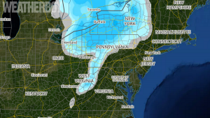
And while the calendar says May, some areas will see snow too this weekend. While snowflakes will fly as far south as northern New Jersey, central Maryland, and western Virginia, some of those flakes may accumulate over the higher terrain of Upstate New York , northern Pennsylvania, and the highest elevations of western Maryland and eastern West Virginia.

Those looking forward to warmer, drier conditions will need to wait in the eastern United States. An unusually potent and positioned upper level low will keep conditions colder and more wet than usual over much of the Northeast, Great Lakes region, and Mid Atlantic. There could be additional threats of frost and freeze conditions, which will delay some for getting a jump start on their spring plantings. The unsettled, cooler-than-normal conditions could linger for at least the next 5-10 days.


Primary Sidebar

Sponsored Ad

Search

Latest News

  • Earthquake Rattles Near North Carolina / South Carolina / Georgia State Lines
  • Tornado Risk Increases for New Jersey, Delaware, Maryland, Virginia, & North Carolina
  • Last Friday in May to be Stormy in East
  • Tropical Storm Alvin Gains Strength
  • Chief Meteorologist Ed Buckner Dies at 59
  • Tropical Storm Alvin Likely to Form
  • Increased Risk of Landfalling Hurricane to NJ, NY, MD, and DE
  • 90% Chance that Tropical Cyclone will Form Soon, NHC Says
About | Careers | Contact | Contests
Terms | Privacy | Ad Choices
Weatherboy is a (R) Registered Trademark of isarithm LLC, All Rights Reserved.
All content herein is Copyright by Isarithm LLC 1997-2022