While Hurricane Florence inches its way closer to the North Carolina coastline, concerns are growing with where the system will travel over time. While a catastrophic flooding rain event is still in the cards for the Carolinas, questions remain what will happen with the storm, its winds, and its moisture this weekend and beyond.
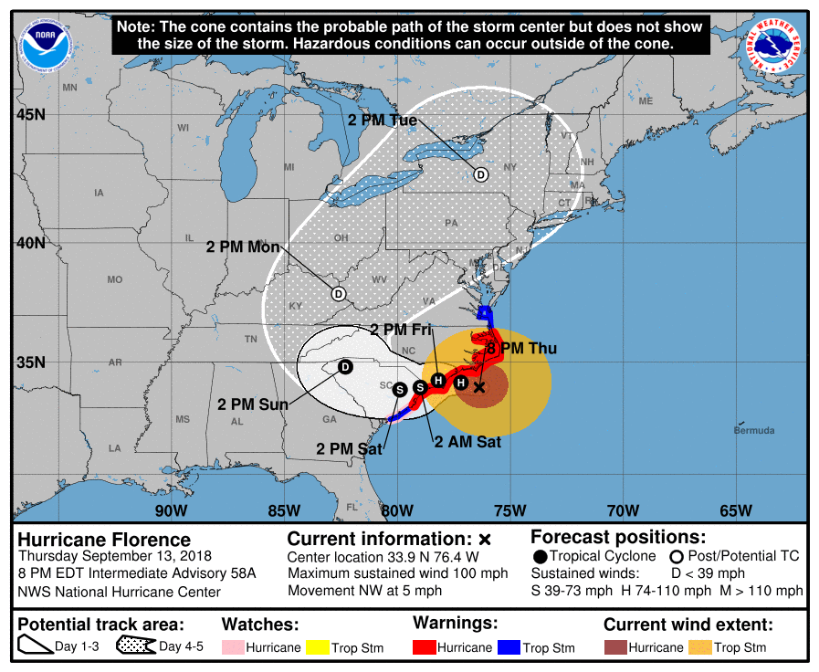
In the short-term, Florence is headed for the Carolinas. Data from NOAA Doppler weather RADARS and an Air Force Reserve Hurricane Hunter aircraft indicate that the center of the eye of Florence was located near latitude 33.9 North, longitude 76.4 West, at 8pm. Florence is moving slowly toward the northwest near 5 mph (7 km/h), but a slow west-northwestward motion is expected to resume tonight or Friday according to the National Hurricane Center (NHC). The NHC also forecasts a slow westward to west-southwestward motion Friday night and Saturday. On this forecast track, the center of Florence will approach the coasts of North and South Carolina later tonight, then move near or over the coast of southern North Carolina and northeastern South Carolina in the hurricane warning area on Friday. A slow motion across portions of eastern and central South Carolina is forecast Friday night through Saturday night.
On this track, catastrophic storm surge and fresh water flooding will inundate a large part of South and North Carolina. More than 30″ of rain is possible in eastern North Carolina, along with winds sustained at tropical storm force or greater for at least 30 hours. The combination of epic rainfall and damaging winds will create a large area of damage.
Beyond Saturday, the National Hurricane Center forecast becomes a bit more blurry. As do global computer forecast models that meteorologists tap into to make weather forecasts. There is good agreement of where Florence will head over the next 36 hours as it slowly creeps along the Carolina coast. Beyond then, though, the two global forecast model giants, the European ECMWF and the American GFS, differ in what’ll happen next.
The American GFS forecast model suggests the core of Florence will move northwest through South Carolina into the Appalachian Mountains, rising to a 1005mb low near the border of West Virginia, North Carolina, and Kentucky late Sunday night. From there, the surface low tracks north into Ohio as the system rains itself out in the Mid Atlantic and Ohio Valley areas on Monday and Tuesday. Tuesday into early Wednesday, heavy rain forms across northern New England and the St. Lawrence Valley and heads north and east into southeast Canada. By Wednesday afternoon, it begins to dry-out in the northeast, but not before dropping widespread 2-4″ of rain there.
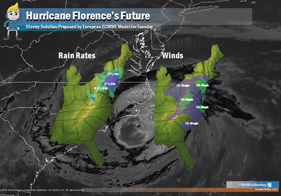
The European ECMWF has a more significant storm heading into the northeast than its American counterpart. This is somewhat concerning because the performance of the European forecast model for this specific storm has been far superior to that of the American GFS. While past performance isn’t necessarily indicative of future performance, it is worthy of additional consideration.
The European ECWMF model suggests the core of Florence will be slower than the GFS suggests and creep to the North Carolina / Tennessee border by Monday morning as a 1004 mb low. Rather than head north towards Ohio, the European model suggests the storm will remain east of the Appalachain mountains and intensify as it heads north and east. By Tuesday morning, it has a 1002 mb low in central Maryland. By Tuesday night, the system intensifies to 1000mb as it approaches southeastern Pennsylvania. Late Tuesday night, the system becomes a 997mb low centered over New York City. The system then picks up speed and moves through southeastern New England, exiting the coast as a 990mb low east of Boston on Wednesday morning.
With central pressure dropping and uplift generating more precipitation, the European model suggests a rather robust storm sliding up into the northern Mid Atlantic and southeastern New England. This afternoon’s model run suggests a bout of exceptionally heavy rain over eastern Pennsylvania, New Jersey, and New York on Tuesday, with rain rates greater than 2-3″ per 6 hour period then. With saturated ground from the recent rains of Tropical Storm Gordon’s remnants along with the end of a wet summer pattern, it won’t take much rain to create big problems in this area.
Winds could also be a problem as this system moves through. The model suggests tropical storm force winds sustained in an area stretching from Norfolk to New York City to Harrisburg, and all points in between, for a time on Tuesday. Some gusts could exceed 50mph at times, should this model solution come to fruition. Combined with soaked soil unable to grab onto roots, many trees could tumble in even lighter winds.
It is still too soon to say with certainty where Florence will go once it’s done with the Carolinas. Because both the American and European models do bring its remnants north in some fashion beyond the weekend, residents should be on alert for changing weather conditions and the possibility of more severe impacts, especially should the latest European ECMWF model run be correct.
