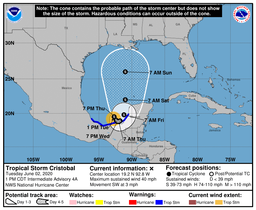
Tropical Depression #3 has been upgraded to Tropical Storm Cristobal, becoming the earliest the third named storm has ever formed this early in hurricane season in the Atlantic Basin. And unfortunately, it appears Cristobal will have an inevitable run-in with the United States. While a U.S. landfall wouldn’t occur before this weekend, it is becoming likely that somewhere along the U.S. Gulf Coast will see direct impacts from this storm. At that time, Cristobal could be either a tropical storm or hurricane.
As of the latest update from the National Hurricane Center (NHC), the center of Tropical Storm Cristobal was located near latitude 19.2 North, longitude 92.8 West. Cristobal is
moving toward the southwest near 3 mph. Maximum sustained winds are near 40 mph with higher gusts. The estimated minimum central pressure is 1004 mb or 29.65 inches.
For now, the NHC expects Cristobal to drift slowly southwestward or southward through tonight and meander over the southern Bay of Campeche through late Wednesday. On the official forecast track, the center of Cristobal is forecast to be near the coast of the southern Bay of Campeche tonight through Thursday. Computer forecast guidance differs beyond Thursday where the storm will travel, although almost all guidance is in agreement that the U.S. will be a target. Because uncertainty remains in the extended forecast, all residents of the U.S. Gulf Coast from Texas to Florida should make sure they have their Hurricane Action Plans in order; it may become necessary to act on them.
Even before Cristobal arrives at the U.S. shoreline, it’ll present many hazards to portions of Central America. Cristobal is expected to produce total rain accumulations of 10-20″ inches with isolated maximum amounts of 25″ over parts of the Mexican states of Tabasco, Veracruz, and Campeche. The tropical storm is also expected to produce total rain accumulations of 10-15″ over northern Chiapas and other Mexican states, Quintana Roo and Yucatan. Additional rainfall of 10-15″ with isolated amounts of 25″ is expected along the Pacific coasts of Chiapas, Guatemala, and El Salvador. Some of these Pacific locations received 20″ of rain over the weekend and storm total amounts of 35″+ are possible. With an overabundance of rain, life-threatening flash floods and mudslides will occur.
