• Skip to primary navigation
  • Skip to main content
  • Skip to primary sidebar

Weatherboy

Weatherboy Weather News, Maps, RADAR, Satellite, and Forecasts.

  • Local
  • Earth Science News
  • RADAR
  • Current Warnings
  • Satellite
  • Current Maps
  • Forecast Maps
  • Video

Dam Crisis Continues: Trouble Ahead

by Weatherboy Team Meteorologist - February 13, 2017

Illustration by the Sacramento office of the National Weather Service illustrates the area around the Oroville Dam that could fail.

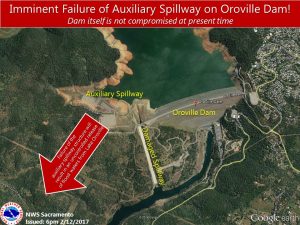
Roughly 190,000 have been evacuated below the Lake Oroville Dam in California as an emergency, auxiliary spillway shows signs of failure. With experts at the dam expecting an imminent failure of the spillway area Sunday evening, evacuations were ordered as the output of the dam was increased to 100,000 cubic feet per second to alleviate the surplus of water that exists in the lake.

The increased release appears to have prevented additional water from topping the spillway, but the danger of failure remains. As a result of the ongoing failure risk, evacuation orders remain up for the area near the dam.

“The situation has been stressful,” said Mark Ghilarducci, director of the state Office of Emergency Services. “It’s complex and rapidly changing, so we are doing everything we can to support Butte County and the local authorities to be able to address most of the folks who have been displaced.”


California Governor Jerry Brown released a statement Sunday evening after the evacuation order was issued by local authorities. “I’ve been in close contact with emergency personnel managing the situation in Oroville throughout the weekend, and it’s clear the circumstances are complex and rapidly changing,” Brown said. “I want to thank local and state law enforcement for leading evacuation efforts and doing their part to keep residents safe. The state is directing all necessary personnel and resources to deal with this very serious situation.”

The 7-day outlook from the National Weather Service's Weather Prediction Center shows more heavy precipitation will be impacting California in the coming days, including the area around the Oroville dam crisis.
The 7-day outlook from the National Weather Service’s Weather Prediction Center shows more heavy precipitation will be impacting California in the coming days, including the area around the Oroville dam crisis.

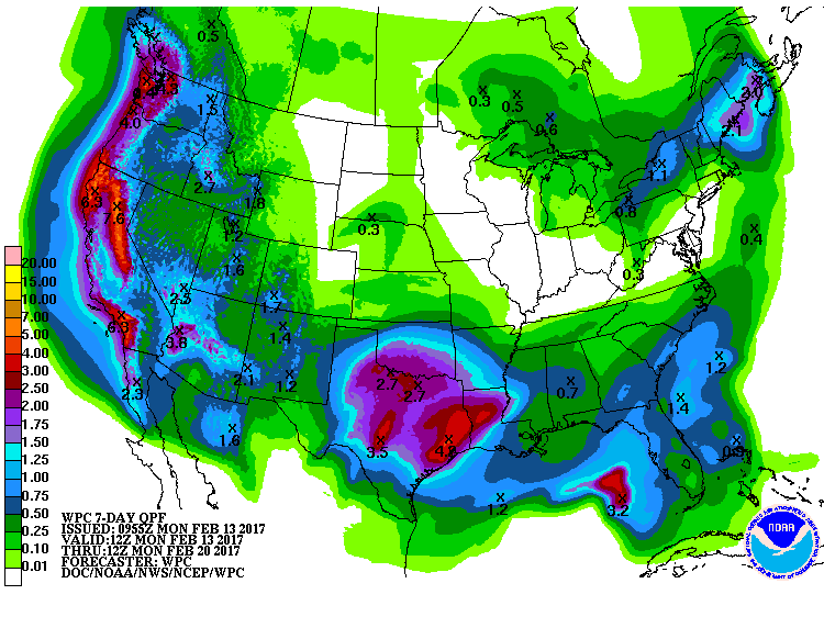
While it appears the auxilliary spillway may be stable at the moment, the weather forecast shows more trouble is in store for the state that has been rocked all winter by heavy rain and snow.

The 7-day outlook from the National Weather Service’s Weather Prediction Center shows more heavy precipitation will impact northern California. The liquid equivalent of 6-7″ of rain and snow is forecast to fall which will put incredible strain on the fragile situation around Lake Oroville.

There is currently 40,000 cubic feet of water arriving into the lake each second now and additional storms will lead to an exponential increase in that flow.  Levees downstream the dam can handle flows of up to 150,000 cubic feet per second before flooding, but with the spillway of the dam compromised and more water rushing in, it may not be possible to hold back the increased flow from increased precipitation.


The Sacramento Bee spoke with Joe Countryman, a member of the Central Valley Flood Protection Board and a former engineer with the U.S. Army Corps of Engineers for context on the engineering issues in the Oroville Dam crisis.  When asked about what a failure of the spillway meant, he told them, “It’s not going to be the main embankment failure, but it’s a failure. If it does happen, there’s nothing saying that the ground is going to stay where it is. That force of water will start tearing that hill apart, and it could eat back into the reservoir and drain the reservoir.”
If such a failure does occur, the cities of Marysville, Oroville, Live Oak, and the Highway 70 corridor are at extreme risk.  Countryman warns about the area, “That’s gone. I’ll tell you right now that’s gone. If they lose that 30 feet that’s gone”, suggesting the Highway 70 corridor and surrounding communities would be wiped out by the breach.
The Oroville Dam was built in the 1960s; it is an earthfill embankment dam on the Feather River east of the city of Oroville.  At 770 feet high, it is the tallest dam in the US and serves mainly for water supply, hydroelectricity generation and flood control. The dam holds back Lake Oroville, the second largest  man-made lake in the state of California.

Primary Sidebar

Sponsored Ad

Search

Latest News

  • July to Start with Severe Weather Event in New Jersey, Pennsylvania, Delaware, & Maryland
  • Tropical Storm Barry Forms; Additional Storm Possible Near Florida
  • Severe Weather Threat & Tornado Risk Returns to Northeast Today
  • Hurricane Center Monitoring Possible Gulf Disturbance
  • Bolide Explodes over Southeastern United States; Piece Crashes into Home
  • 88 Earthquakes Strike Puerto Rico and Dominican Republic; No East Coast Tsunami Threat
  • Andrea Fades Away; No Other Tropical Cyclone Threats around US
  • Tropical Storm Andrea Forms Kicking Off the 2025 Atlantic Hurricane Season
About | Careers | Contact | Contests
Terms | Privacy | Ad Choices
Weatherboy is a (R) Registered Trademark of isarithm LLC, All Rights Reserved.
All content herein is Copyright by Isarithm LLC 1997-2022