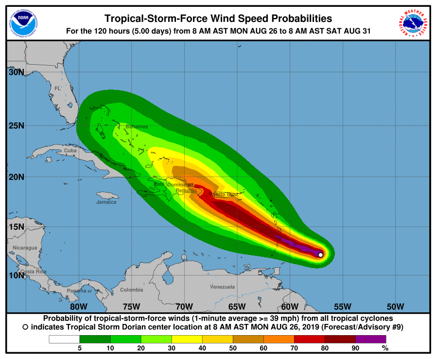
Tropical Storm Dorian is forecast to gain strength over time, prompting a new batch of watches and warnings to be issued by officials in the Caribbean. A Hurricane Watch is now in effect for St. Lucia while a Tropical Storm Warning is in effect for Barbados, Martinique, St. Lucia, St. Vincent, and the Grenadines. A Tropical Storm Watch is in effect for Dominica, Grenada, and its dependencies, Saba, and St. Eustatius.
Each watch or warning carries a different meaning. A Hurricane Watch means that hurricane conditions are possible within the watch area, in this case, within the next 24 hours. A Tropical Storm Warning means that tropical storm conditions are expected somewhere within the warning area within 36 hours. A Tropical Storm Watch means that tropical storm conditions are possible within the watch area, generally within 48 hours. Interests in Puerto Rico, the Virgin Islands, and Hispaniola should monitor the progress of Dorian as watches for these areas later could be required later today.
As of the latest advisory issued by the National Hurricane Center in Miami, Florida, the center of Tropical Storm Dorian was located by satellite and Martinique radar near latitude 12.5 North, longitude 58.3 West. Dorian is moving toward the west-northwest near 14 mph and this motion is expected to continue through Tuesday night, followed by a turn toward the northwest on Wednesday. On the forecast track, the center of Dorian is expected to be near the Windward Islands late today and tonight, and move into the eastern Caribbean Sea on Tuesday. Dorian is expected to pass near or south of Puerto Rico on Wednesday and approach eastern Hispaniola Wednesday night.
Maximum sustained winds are near 60 mph with higher gusts. Some strengthening is forecast during the next few days, and Dorian could be near hurricane strength when it passes through the northern Windward Islands on Tuesday, and it is expected to be a hurricane when it moves near Puerto Rico and eastern Hispaniola.
Dorian is a relatively small tropical cyclone. Tropical-storm-force winds only extend outward up to 45 miles from the center. The estimated minimum central pressure is 1002 mb or 29.59 inches of mercury.
It is still too soon to know precisely what the impacts of Dorian will be on Puerto Rico and Hispaniola. And it is even harder to understand where this system could go, if it remains in tact, beyond those locations. As such, residents should keep a close eye on Dorian in the coming days should its track threaten the U.S. in any way.
For now, Dorian will bring heavy rains, gusty winds, and rough surf to islands in its immediate path. Dorian is expected to produce total rain accumulations of 3 to 8 inches in the Windward Islands from Martinique south to St. Vincent, including Barbados. Isolated maximum totals of 10 inches are possible across the northern Windward Islands. Rainfall totals of 1 to 3 inches are expected from the Grenadines, south to Grenada and across Dominica. Hurricane conditions are possible tonight and early Tuesday within the Hurricane Watch area in the Lesser Antilles. Tropical storm conditions are likely in the warning area by late today. Tropical storm conditions are possible within the tropical storm watch area by tonight or Tuesday. Swells generated by Dorian will be affecting portions of the Lesser Antilles by late today. These swells could cause life-threatening surf and rip current conditions.