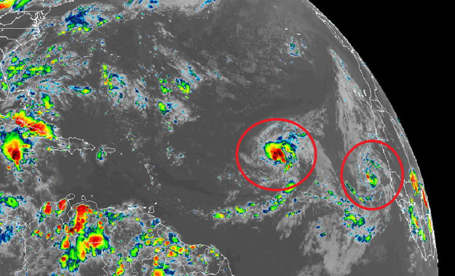
With the traditional peak of the Atlantic Hurricane Season just days away, Mother Nature is in full swing this Labor Day holiday with two fresh tropical storms: Paulette and Rene. Paulette formed early this morning over the east-central Atlantic while Rene formed late this afternoon over the far eastern Atlantic.
For now, Paulette is drifting northwestward over the Central Atlantic. Paulette is located about 1,220 miles west of the Cabo Verde Islands and abut 1,360 miles east of the Northern Leeward Islands. Maximum sustained winds ate 40 mph.
Meanwhile, Rene is about 115 miles east of the Cabo Verde Islands, prompting authorities there to issue a Tropical Storm Watch for the storm. Tropical-storm force winds and heavy rainfall is expected around the Cabo Verde Islands tonight and early tomorrow. Like Paulette, maximum sustained winds are around 40 mph.
With Paulette and Rene forming today, more Atlantic Hurricane Basin records are falling. Prior to today, the earliest “P” storm on record was 2005’s Philippe which formed on September 17 of that year; the earliest “R” storm was Rita which formed on September 18 of the same year. 2005 was an especially busy hurricane season with the most storms on record; it appears 2020 may challenge that record.
The the earliest “S” storm on record to form in the Atlantic basin was Stan which also formed in 2005 on October 2. That record could fall too if either of the two other systems the National Hurricane Center is tracking develops into a tropical cyclone.
Beyond Paulette and Rene, the National Hurricane Center is monitoring an area of low pressure located just southwest of Bermuda. This disturbance is producing disorganized showers and a few thunderstorms. Some slow development of this system is possible during the next several days while it moves generally westward or west-northwestward towards the U.S. East Coast. The National Hurricane Center believes there’s only a 10% chance that a tropical cyclone will form here over the next 48 hours; however, those odds grow to 30% over the next 5 days.
Another system being monitored by the National Hurricane Center is a tropical wave which is forecast to emerge off the west coast of Africa late Wednesday or Thursday. Gradual development is anticipated once the system moves over water, and a tropical depression could form late this week or over the weekend while the system moves generally westward across the eastern Atlantic. The National Hurricane Center says there’s a 50-50 chance that this system will develop into a tropical cyclone over the next 5 days.
The 2020 Atlantic Hurricane season runs through November 30. Traditionally, September 10 marks the peak of the season.